Field Visit


Date 25 March 1930
Event ID 1098904
Category Recording
Type Field Visit
Permalink http://canmore.org.uk/event/1098904
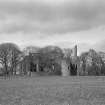
Balmbreich Castle.
In a plantation on the Seabraes, the steep southern shore of the Firth of Tay, 21 miles north-east of Newburgh, is the ruin of an extensive castle, now a mere shell in a dangerous state of disrepair. The site is level with the land behind it, but slopes gradually downwards on the north, terminating abruptly on the raised beach in a cliff 20 feet above the water. It is defined on the east by the deeply worn course of a little burn, and there are traces of another burn on the western side. The buildings form an enclosure, oblong in shape, except at the north-east angle which is oblique. As will be pointed out presently, some slight remains to the east seem to indicate an outer courtyard of relatively late date. Although the structures within the enclosure are better preserved, analysis of their plan has been made difficult by the demolition, towards the end of the 16th century, of a large and elaborate building, which formed part of them and material from which has been used as packing in later walls. In the first stage, so far as can be ascertained, the main enclosure was bounded by ranges of building on at least three sides. The northern range, fronting the water, was only two storeys in height and, owing to the slope, even its upper floor lay rather lower than the level of the ground behind. On the west was a second range, whose height is uncertain, but which ran almost the entire length of the present west wall. At its southern end it abutted on a third range, two storeys high, which ran at right angles to it in an easterly direction, but did not extend the full width of the courtyard, leaving the enclosure on this side to be completed by a screen wall. This screen wall - in which was the original entrance, a wide, arched gateway - was in alignment with the inner wall of the range, the rooms of which, therefore, projected southwards beyond it. The eastern side of the courtyard also was a screen wall. For the greater part of its length the latter ran parallel to the west range, trending westwards, however, as it neared the north-eastern corner and so giving the angle there the obliquity already referred to. These early buildings may be dated to the 14th century, but they underwent extensive alteration and repair. The north range was first raised in height and then demolished, when its inner wall became what it is now, one of the outer walls of the castle. In the north-western angle of the enclosure are traces of an archway, built in two chamfered orders. This is usually described as the original entrance, but its position and architectural features negative the suggestion. It was obviously the access to a chamber on the upper floor of the missing north range, and this must have been a room of some dignity, to judge from the arch details. In the northern half of the west range two built-up windows and a garderobe with a projecting flue may also be regarded as original, while a built-up archway lying behind a later projection for a chimney in the southern part of the range is probably of the same time.
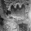
The south range contains more of the original building, but in a greatly altered condition. The lower floor here was a cellarage. The upper one was a chapel, and in its east gable are the remains of a large Gothic window, which has probably been of three lights with a traceried head. In the south wall are the upper parts of three sedilia (SC1110973), seemingly of 14th century date, as well as the back of a piscina or credence and the remains of two long Gothic windows, the arch-heads of which appear to have died out on the jambs in discontinuous imposts. Towards the end of the 15th century the chapel was transformed into a living-room and covered with a pointed barrel-vault, the floor level being lowered. The fact that the sedilia were concealed by the haunch of this vault accounts for their preservation. An aumbry in the south wall, with curvilinear head (SC1110973), is probably part of the chapel furnishings, reinserted at a convenient height above the new floor. At the same time the upper part of the east gable was taken down and replaced by a parapet borne on flatly sectioned corbels, while what remained of the window beneath was filled in and a chimney built behind it.
[see RCAHMS 1933, 146-149, for a full architectural description]
HISTORICAL NOTE. A charter of entail in 1390 confirms to Norman Leslie the lands of the barony of "Balnebrech," which he already possessed, the life-rent being reserved to his father (1). Thereafter the property continues in the line of the Leslies, Earls of Rothes. A charter of 1517 to George, fourth Earl of Rothes, specifies in the grant “the barony and castle of Ballenbreich” (2). It is said that about 1835 "an iron plate, apparently part of the outer door of the castle, was in existence, bearing the initials and date A.E.R. 1572, which was supposed to refer to Andrew, Earl of Rothes" (3). The date would agree with that suggested for certain parts of the building, but a relic of this character is unusual. In 1680 the seventh Earl of Rothes was created Duke of Rothes, "Marquess of Bambreich," &c., the latter spelling representing the local pronunciation of the name.
RCAHMS 1933, visited 25 March 1930.
(1) Reg. Mag. Sig., s.a., No. 808. (2) Ibid., s.a., No. 148. (3) Millar's Fife, Pictorial and Historical, ii, p. 324. Cf. also Cast. and Dom. Arch., ii, p. 411.