
Pricing Change
New pricing for orders of material from this site will come into place shortly. Charges for supply of digital images, digitisation on demand, prints and licensing will be altered.
Mangerton Tower


Tower House (Medieval)
Site Name Mangerton Tower
Classification Tower House (Medieval)
Canmore ID 67872
Site Number NY48NE 3
NGR NY 47975 85340
Datum OSGB36 - NGR
Permalink http://canmore.org.uk/site/67872


- Council Scottish Borders, The
- Parish Castleton
- Former Region Borders
- Former District Roxburgh
- Former County Roxburghshire
NY48NE 3 4797 8534
(NY 4797 8533) Mangerton Tower (NR) (Remains of)
OS 6" map (1957)
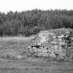
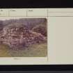
Mangerton Tower has been reduced to its lowest storey, the walls on two sides being represented by little more than foundations, and having a maximum height of 8 ft at the SW angle. It has been oblong on plan, measuring 34 ft 3 ins N-S by 26 ft 3 ins over walls 5 ft thick. An armorial panel, dated 15 (8?)3 has been inserted in the W wall.
RCAHMS 1956, visited 1931
Alexander Armstrong, laird of Mangerton, is noted in 1378; throughout the 16th century the Armstrong chiefs resided at Mangerton, but in 1629, Francis Scott was provided with the lands of Mangerton, along with 'the castle, tower and fortalice thereof'.
W A Armstrong 1960
Mangerton Tower (name verified) is situated on low-lying level pastureland. The NW wall is 10.5m long and survives intact up to a height of 2.6m; a portion of inner wall face indicates a thickness of 1.6m. The NE and SW walls are now only 3.8m and 7.3m long respectively and there is no surface trace of the SE wall. The interior is filled with rubble which is now turf-covered. The armorial stone is as described. The tower is recored on an 1818 estate map as The Old Castle of Mangerton (M Robson, Hawick Museum).
Surveyed at 1:2500.
The RCAHMS state that this tower was burned in 1543, 1569 and laid waste in 1602.
Visited by OS (MJF) 26 July 1979
Field Visit (February 1996)
Mangerton Tower measures 10.4m from NE to SW by 7.7m transversely over a wall 1.55m in thickness. At the W corner, which has been rebuilt recently, the wall stands up to 2.8m high, but on the NE and SE it is reduced to grass-grown footings. The interior is filled with rubble, again grass-grown, and there is a pile of rubble against the SE wall that may be the remains of an external stair. An armorial panel has been inserted into the outer face of the wall on the NW. It is enclosed by a roll moulding (missing along the bottom edge and on the lower left side) and bears the date 1563, below which there is a shield displaying, on the left, a chevron over a lozenge and, on the right, a sword flanked by the initials SA and EF. The tower is now in the care of the Armstrong Clan Trust.
(LID96 41)
Visited by RCAHMS (SDB) February 1996
Sbc Note
Visibility: Upstanding building, which may not be intact.
Information from Scottish Borders Council

