
Pricing Change
New pricing for orders of material from this site will come into place shortly. Charges for supply of digital images, digitisation on demand, prints and licensing will be altered.
Castle O'er Estate


Linear Earthwork (Iron Age)
Site Name Castle O'er Estate
Classification Linear Earthwork (Iron Age)
Alternative Name(s) Birkie Sike; Cleave Sike; Whiteyett; Slippery Knowe
Canmore ID 67410
Site Number NY29SW 41
NGR NY 24857 93356
NGR Description NY 24807 93515 to NY 24796 93147
Datum OSGB36 - NGR
Permalink http://canmore.org.uk/site/67410


- Council Dumfries And Galloway
- Parish Eskdalemuir
- Former Region Dumfries And Galloway
- Former District Annandale And Eskdale
- Former County Dumfries-shire
Remains of later prehistoric multivallate enclosure located in a natural 'amphitheatre' created by local topography, on the western bank of the White Esk. Part of wider later prehistoric landscape, but likely functioned as a focal point for ritual activity within this landscape.
information from Héléna Gray, (CFA Archaeology Ltd), August 2015
OASIS ID: cfaarcha1-278420
Scheduled (with NY29SW 41 and NY29SE 68) as 'Whiteyett, earthworks 575m SSE to 935m S and 650m S to 1060m S of... the earthwork remains of two discrete lengths of double linear abanks and [a] medial ditch, interpretred asd evidence of pastoral agricultural practice dating to the early centuries of the 1st millennium AD [and also] the earthwork remains of an unfinished settlement...'
Information from Historic Scotland, scheduling document dated 24 March 2010.
Field Visit (August 1980)
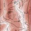
Castle O'er Estate, Linear Earthworks, NY 934 to 248 931, NY29SW 41 248
The existence of linear earthworks around Castle O'er fort (NY29SW 10) was first noted by William Roy in the mid-eighteenth century. In 1896, Richard Bell, a local antiquary, recorded an extensive system of 'trenches' on a map of the Castle O'er estate; this map is now in the Dumfries Museum. Although many of the features recorded by Bell appear to be old roads, tracks and stream gullies, there can be little doubt that large areas around the Castle O’er fort were once enclosed by linear earthworks in conjunction with natural features.
(S) NY 248 934 to 248 931; this linear earthwork links the gullies of Birkie Sike and Cleave Sike. Three linear earthworks can be identified on the E side of the River White Esk but no link can now be demonstrated with those on the W side; two (R and S) cut off the area around Slippery Knowe in conjunction with stream gullies and the White Esk.
See also NY29SW 9, NY29SW 10, NY29SW 32, 42-5, NY29SE 67, NY29SE 68 and NY29SE 70--72.
RCAHMS 1980, visited August 1980
(SRO, RHP 9629; Roy 1793, 120; Stat. Acct., xii, 1794, 607; Fraser 1878, ii, 467-8; Armstrong 1883, 147 and Appendix, p. viii, no. iii; Christison 1898, 159-62, 360-2; Bell 1905; RCAHMS 1920, pp. 71-3, Nos. 176-7; NMRS, DFD/156/1, DFD/157/1, DFD/303/39-4-2)
Note (1997)
NY 24 93 NY29SW 41
Listed as linear earthwork (with NY29SW 32, 42-5 and NY29SE 67-72).
RCAHMS 1997.
Project (29 May 2014)
An archaeological evaluation was undertaken by CFA Archaeology Ltd, a desk based assessment and walk over survey (May 29th 2014) was conducted
The historic environment record within the Site Boundary is relatively limited, although there is some potential for the proposed development site to contain previously unknown heritage assets from at least the later prehistoric period onwards, given the historic landscape character of the wider area. Taking this into account, the archaeological potential of the proposed development site is considered to be low.
A summary assessment, on a site by site basis, of the predicted effects on the settings of assets within a 10km radius where the blade tip ZTV indicates that there would be theoretical views of one or more turbines
information from Héléna Gray, (CFA Archaeology Ltd), August 2015
OASIS ID: cfaarcha1-278420

