
Pricing Change
New pricing for orders of material from this site will come into place shortly. Charges for supply of digital images, digitisation on demand, prints and licensing will be altered.
Trailflat


Barrow(S) (Prehistoric), Pit(S) (Period Unassigned), Pit Circle (Prehistoric)(Possible)
Site Name Trailflat
Classification Barrow(S) (Prehistoric), Pit(S) (Period Unassigned), Pit Circle (Prehistoric)(Possible)
Canmore ID 66303
Site Number NY08SE 43
NGR NY 05121 84852
Datum OSGB36 - NGR
Permalink http://canmore.org.uk/site/66303


- Council Dumfries And Galloway
- Parish Tinwald
- Former Region Dumfries And Galloway
- Former District Nithsdale
- Former County Dumfries-shire
NY08SE 43 05120 84851
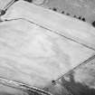
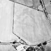
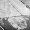
Cropmarkings on oblique aerial photographs (RCAHMSAP 1983-4) reveal four round barrows measuring up to 6m in diameter within a ditches about 2m in breadth. Each is no more than 10m from the next; three lie in a straight line while the fourth is slightly offset.
Information from RCAHMS (DCC) 16 January 1998
Aerial Photographic Transcription (17 July 2012)
An interpretative transcription, or mapping, of information on oblique aerial photographs was produced on 17 July 2012.
Aerial Photographic Interpretation (29 November 2013)
What may be a pit circle has been recorded as a cropmarking on oblique aerial photographs (NY 05101 84889; RCAHMSAP 1984) some 27m NW of the round barrows. It measures around 7m in diameter and is defined by nine or ten pits.
Information from RCAHMS (KMM) 29 November 2013

