
Comlongon


Enclosure (Period Unassigned), Fort (Period Unassigned)(Possible)
Site Name Comlongon
Classification Enclosure (Period Unassigned), Fort (Period Unassigned)(Possible)
Alternative Name(s) Comlongon Castle Policies; Comlongan
Canmore ID 66070
Site Number NY06NE 5
NGR NY 08261 68931
Datum OSGB36 - NGR
Permalink http://canmore.org.uk/site/66070


- Council Dumfries And Galloway
- Parish Ruthwell
- Former Region Dumfries And Galloway
- Former District Nithsdale
- Former County Dumfries-shire
Aerial Photographic Transcription (4 July 2012)
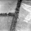
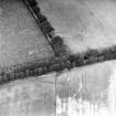
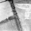
This section of an enclosure has been recorded as a cropmark on oblique aerial photographs (RCAHMSAP 1984). It is roughly curvilinear in plan and defined by sections of two ditches each about 4.5m wide, and 12.4m apart at the N. There is also a section of ditch that may relate to a later field boundary.
Information from RCAHMS (KHJM) 4 July 2012

