
Pricing Change
New pricing for orders of material from this site will come into place shortly. Charges for supply of digital images, digitisation on demand, prints and licensing will be altered.
Upcoming Maintenance
Please be advised that this website will undergo scheduled maintenance on the following dates:
Thursday, 9 January: 11:00 AM - 3:00 PM
Thursday, 23 January: 11:00 AM - 3:00 PM
Thursday, 30 January: 11:00 AM - 3:00 PM
During these times, some functionality such as image purchasing may be temporarily unavailable. We apologise for any inconvenience this may cause.
Dumfries, Heathhall Airfield


Airfield (First World War), Military Airfield (Second World War)
Site Name Dumfries, Heathhall Airfield
Classification Airfield (First World War), Military Airfield (Second World War)
Alternative Name(s) Heathhall Industrial Estate; Raf Dumfries; Tinwald Downs Farm Landing Ground
Canmore ID 91761
Site Number NX97NE 153
NGR NX 9977 7885
NGR Description Centred NX 9977 7885
Datum OSGB36 - NGR
Permalink http://canmore.org.uk/site/91761


- Council Dumfries And Galloway
- Parish Dumfries
- Former Region Dumfries And Galloway
- Former District Nithsdale
- Former County Dumfries-shire
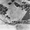
Heathall airfield began life as the Tinwald Downs Farm landing ground of the Arrol Johnston Ltd factory (just to the west), which in the First World War shifted production from motor cars to aeroplane engines, and later in the war, to complete aircraft. The site of Tinwald Downs Farm lay within the footprint of the technical area of the Second World War aerodrome. Fife notes that the landing ground was for the delivery of spare parts by air, rather than the flying out of aeroplanes produced here, and notes the delivery of completed aeroplanes by rail to Renfrew aerodrome.
Information from HS/RCAHMS World War One Audit Project (GJB) 31 May 2013
NX97NE 153.00 centred 9977 7885
Extends onto map sheet (see NY07NW 46 and NY07NW 47 NX98SE.
NX97NE 153.01 NX 99992 78537 Museum; Control Tower
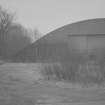
NX97NE 153.02 NX 99361 79880, NY 99334 80097 and NY 99479 80168 (NX98SE) Aircraft Hangar
NX97NE 153.03 NX 99860 79281 , NX 99958 79177 and NY 00103 79138 Aircraft Hangars
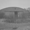
NX97NE 153.04 c.NX.9913 7920 Pillbox
NX97NE 153.05 c. NX.9911 7892 Pillbox
NX97NE 153.06 c. NX.9937 7963 Pillbox
NX97NE 153.07 c. NX 9902 7863 Pillbox
NX97NE 153.08 NX 99685 78471 and NX 99528 78517 Aircraft Hangars
NX97NE 153.09 NX 99937 79653 Pillbox
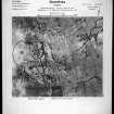
Visible on vertical air photographs (OS 79/040/003-5, flown 1979).
(Undated) information in NMRS.
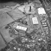
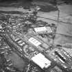
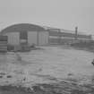
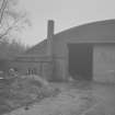
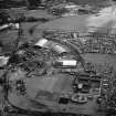
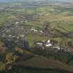
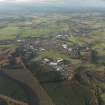
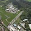
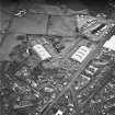
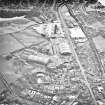
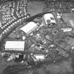
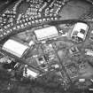
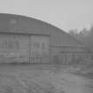
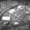
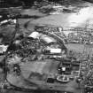
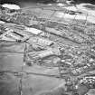
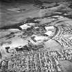
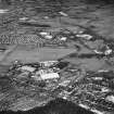
Planned as an Aircraft Storage Unit in the pre-war period, this airfield opened during 1940. By 1945 the area was used for aircraft storage with one of the runways being closed to create space. It closed as an RAF station during 1957 and it subsequently developed into an industrial estate in 1959. Many of the hangars are still used for storage and the control tower now houses the Dumfries and Galloway Aviation Museum (NX97NE 153.01).
D J Smith 1983
The blister hangars on the W side of the airfield visible postwar RAF vertical air photographs (58(A) 382, 5378-5379, flown 19 May 1948) have been removed by the construction of postwar housing in Downs Way.
Information from RCAHMS (DE), July 2004
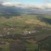
The remains of Heathhall Airfield with its defences is situated within the recent Heathhall housing estate. Only the southern part of the runways survive along with eight aircraft hangars of J, K and L types with the control tower (NX97NE 153.01). Only one defensive pillbox was extant in 1988 (All Scotland Survey [Jasair], 22 88 244-245, flown 10 June 1988), which is also shown on the current OS 1:2500 scale digital map. One type L hangar would appear to have been removed more recently as it is not shown on the current OS 1:2500 scale digital map, though it does appear on the 1988 images. Other remains are part of the bomb store or muintions depot, and part of the rifle range and aircraft shooting butt ( ).
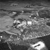
The airfield is visible on RAF WW II vertical air photographs (FNO 158, 6.3-6.12, flown 26 September 1942 and large 1:5000 scale vertical air photographs (106G/UK 1314, 5005-5016, 5029-5037; 5049-5054, flown 27 March 1946), which show that at that date there were fourteen large aircraft hangars, three Bellmans, one type E, eight type J and two type L and at least eleven blister hangars. In addition an extensive technical area (centred NY 0045 7835 and NY 0010 7930) to the E of the two arcs of three aircraft hangars.
A defensive ring of pillboxes, mostly type 22 or 27, are also visible on the air photographs taken in 1946 along with the ancilliary buildings, accommodation and training.
The airfield originally occupied approximately 174.45 hectares.
Information from RCAHMS (DE), April 2006
Project (March 2013 - September 2013)
A project to characterise the quantity and quality of the Scottish resource of known surviving remains of the First World War. Carried out in partnership between Historic Scotland and RCAHMS.

