
Scheduled Maintenance
Please be advised that this website will undergo scheduled maintenance on the following dates: •
Tuesday 3rd December 11:00-15:00
During these times, some services may be temporarily unavailable. We apologise for any inconvenience this may cause.
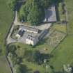
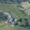
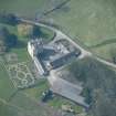
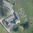
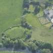
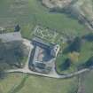
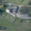
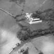
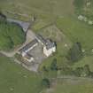
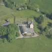
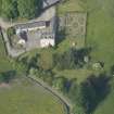
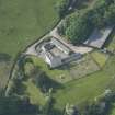
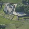
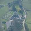
Buittle Place


Tower House (Medieval)
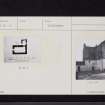
Site Name Buittle Place
Classification Tower House (Medieval)
Alternative Name(s) Buittle Castle; Old Buittle Tower
Canmore ID 64983
Site Number NX86SW 10
NGR NX 81817 61652
Datum OSGB36 - NGR
Permalink http://canmore.org.uk/site/64983


- Council Dumfries And Galloway
- Parish Buittle
- Former Region Dumfries And Galloway
- Former District Stewartry
- Former County Kirkcudbrightshire
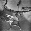
NX86SW 10 81834 61699
Tower [NAT]
OS (GIS) MasterMap, August 2009.
See also NX86SW 1 and NX86SW 6.
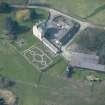
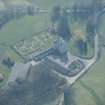
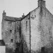
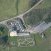
A probably late - 16th century L-shaped tower stands among the farm buildings of Buittle Place. Although ruinous in 1790 it has since been restored. The exterior of the building is harled and whitewashed.
RCAHMS 1914
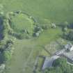
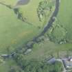
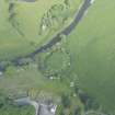
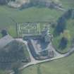
The house is three storeys high and is surrounded by a ditch with the exception of that part against the Water of Urr which was defended by a rampart.
Name Book 1847
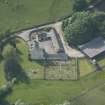
NX 8181 6165. This tower, or fortified house, is as described above. It is in a good state of repair and is in occupation as the farm-house. Part of the ditch which formerly surrounded the house can be seen to the north of the farm steading running north-east, then east to the Water of Urr. This ditch is part of the triangular court of Buittle Castle (NX86SW 6).
No trace was seen of the rampart against the Water of Urr, mentioned by ONB but this is probably the east scarp of the triangular court of Buittle Castle.
Visited by OS (WDJ) 14 July 1969
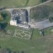
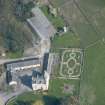
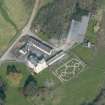
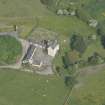
This ongoing excavation (cf DES 1995, 21), now in its sixth season and staffed entirely by volunteers, has uncovered much artefactual and some settlement evidence for the presence of early man in Galloway in the form of Mesolithic, Neolithic/Early Bronze Age, Iron Age and Roman occupation levels.
Further evidence of the existence of the medieval Royal Burgh of Botel (1323/24) has been uncovered. The post-holes of both round and rectangular timber buildings have been excavated as well as additional building evidence in the form of stables set in behind the timber palisaded defences on the S and E defensive perimeters of the site. Evidence of bronze casting and associated metalworking was found. Artefacts recovered include a Papal Bulla of Pope Honorious IV (1285-87), bronze jewellery and clothing accessories.
The remains of a building with stone foundations has been uncovered; above it was a later hearth and below it a Neolithic pasture level. From the immediate vicinity of this building, artefactual evidence in the form of bronze buckles, a seal matrix, a coin of Edward III dated to 1356-61, part of a wooden sword scabbard covered with a fine layer of copper, and items of domestic use, date this construction to the mid-14th-century era when (King) Edward Balliol (1332-56) was known to be in residence in Botel Castle after 1346.
A large domestic hearth has been uncovered in one trench with a soakaway running along its length, and from this 131 large sherds of fire-blackened, yellow-green glazed pottery have been excavated. In the immediate vicinity of this hearth a pit and a sump have been found.
An area of prehistoric pasture land has yielded a number of lithics, and there is post-hole and pottery evidence of an early roundhouse on this level.
In advance of the construction of a riverside walk, excavations have started in the fosse to the N of the bailey and have yielded evidence of 13th-century construction of two stone walls and a massive buttress which could have formed the base for a drawbridge or gateway leading from the S bailey to a smaller N one which could have been an animal pend.
A Penman 1996.

