
Pricing Change
New pricing for orders of material from this site will come into place shortly. Charges for supply of digital images, digitisation on demand, prints and licensing will be altered.
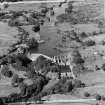
Tongland Loch, Dam


Dam (Mid 20th Century) (1934)
Site Name Tongland Loch, Dam
Classification Dam (Mid 20th Century) (1934)
Alternative Name(s) Tongland Works; Tongland Reservoir, Dam; Galloway Hydroelectric Scheme; River Dee
Canmore ID 195343
Site Number NX75SW 37
NGR NX 70237 54486
Datum OSGB36 - NGR
Permalink http://canmore.org.uk/site/195343


- Council Dumfries And Galloway
- Parish Kirkcudbright
- Former Region Dumfries And Galloway
- Former District Stewartry
- Former County Kirkcudbrightshire
NX75SW 37 70237 54486
Tongland Dam [NAT]
OS 1:10,000 map, 1981.
For (associated) Tongland Power Station (NX 69512 53559), see NX65SE 86.00.
For (associated) Tongland Loch (Tongland Reservoir, centred NX 704 554), see NX75NW 78.
For (associated) Tongland Tunnel or Aqueduct (NX 7012 5458 to NX 6951 5356), see NX75SW 43.
Tongland dam, contractor: John Howard and Co. Ltd. The Tongland Dam has been built across a gorge of the River Dee a few miles above the town of Kirkcudbright (NX65NE 67); it marks the lowest limit of the catchment area. This dam holds up the water in the river and creates a small reservoir with a top water level about 120ft (36.6m) above OD.
The major portion of the dam is of horizontal arch type, measuring about 70ft (21.3m) in height from river bed level. To the E, it is continued as a mass concrete gravity structure as far as a pair of large free roller flood gates, beyond which there is a fixed flood spillway 300ft (91.5m) long.
Anon. 1934 ['Galloway water Power Scheme'].
Tongland Dam
Purpose: to create head and provide daily storage
Type: arch and gravity
Maximum height of footway above river-bed: 72ft (22m)
Total length along crest: 977ft (297.9m)
Length of arch portion of dam: 290ft (88.4m)
Radius of arch portion of dam: 145ft (44.2m)
Batter of downstream face of arch portion of dam: 4 to 1
Spillway level: 120ft (36.6m) OD
Normal maximum depth over crest: 3ft (0.9m)
Overfall spillway length: 325ft (99.1m), also two floodgates, each 25ft (7.6m) by 31ft (9.5m)
Normal maximum spillway capacity: 30000 cusecs
Anon. 1938 ['Galloway Hydro-Electric Development'].
This dam is situated at the S end of Tongland Reservoir (NX75NW 78), a major element in Stage I of the Galloway Hydro-Electric Scheme. It dams the River Dee, which here forms the boundary between the parishes of Tongland and Kirkcudbright.
A spillway and fish ladder are situated to the E of the dam.
Information from RCAHMS (RJCM), 17 October 2005.
Project (2007)
This project was undertaken to input site information listed in 'Civil engineering heritage: Scotland - Lowlands and Borders' by R Paxton and J Shipway, 2007.
Publication Account (2007)
The southernmost dam of the Galloway scheme, over the Dee, is generally similar in construction to those at
Kendoon, Carsfad and Earlstoun. It is a combined concrete arch and gravity dam 977 ft long of which the arched portion is 146 ft radius, 70 ft high and 290 ft long. The gravity section lies to the east of the arch and seals what is believed to be the former channel of the river. To the east of this are flood gates, each 25 ft wide and 31 ft high, and the spillway channel. A long, winding, fish ladder is provided with 29 steps, each with a rise of a little more than 2 ft, and three resting pools.
The water is drawn off from Tongland Reservoir to the power station though an aqueduct tunnel 3335 ft long,
one of the most interesting features being its shape. It is a flattened circle so proportioned as to produce, under the varying internal pressure, an approximately uniform circumferential stress in the steel reinforcement not exceeding 12 000 lb sq in.
The dam and its associated works including the power station were completed in 1934. The consulting engineers were Sir Alexander Gibb & Partners and the main contractor was John Howard & Co. Ltd.
Scottish Power’s Galloway Hydros Visitor Centre at the Power Station, providing information on the scheme and guided tours, is open in the summer and well worth a visit.
R Paxton and J Shipway 2007
Reproduced from 'Civil Engineering heritage: Scotland - Lowlands and Borders' with kind permission from Thomas Telford Publishers.
Field Visit (2010)
This dam regulates the flow of the River Dee and provides a modest storage reservoir in Tongland Loch. Water from the outflow enters a tunnel and thence a concrete pressure aqueduct which conveys it to the base of the surge tower. This dam is a hybrid type, composed of part arch dam and part gravity section with both fixed spillway and siphon valves. It is a significant complex of different engineering approaches to the construction of a dam, each particularly suited to the profile of the valley at that point. The combination of arch and gravity sections is a common theme in the dams on the Galloway scheme. The dam also exhibits a functionalist classical design scheme, especially evident to the control turret which is cohesive with the design of the powerhouse at Tongland. There has been a limited degree of later alteration including the addition of screens and automatic screen cleaners. PL Payne, 1988, 24; E Wood, 2002, 50; G Hill, 1984.

