Pricing Change
New pricing for orders of material from this site will come into place shortly. Charges for supply of digital images, digitisation on demand, prints and licensing will be altered.
Cardoness
Country House (Period Unassigned)
Site Name Cardoness
Classification Country House (Period Unassigned)
Alternative Name(s) Cardonness House; Cardoness Policies; Cardonness Estate
Canmore ID 63703
Site Number NX55SE 8
NGR NX 56643 53608
Datum OSGB36 - NGR
Permalink http://canmore.org.uk/site/63703
- Council Dumfries And Galloway
- Parish Anwoth
- Former Region Dumfries And Galloway
- Former District Stewartry
- Former County Kirkcudbrightshire
NX55SE 8.00 56643 53608
Cardoness [NAT]
OS (GIS) MasterMap, May 2010.
NX55SE 8.01 NX 56308 53228 Laundry Cottage
NX55SE 8.02 NX 56488 53312 Sandyknowes
NX55SE 8.03 NX 56958 83967 East Lodge
NX55SE 8.04 NX 56810 53832 West Lodge
NX55SE 8.05 NX 56876 53430 Chapel
NX55SE 8.06 Centred NX 5631 5352 Home Farm
NX55SE 8.07 NX 5645 5358 Stables
NX55SE 8.08 NX 56654 53631 The Cottage
NX55SE 8.09 NX 5652 5345 Walled Garden
Not to be confused with Cardoness Castle (NX 59059 55274), for which see NX55NE 11.00.
NMRS REFERENCE
Owner: Col Rainsford Hannay
ARCHITECTS: Peddie and Kinnear
S W Burnage c. 1959 - large scale alterations
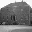
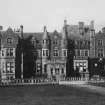
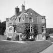
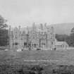
Cardoness was mostly demolished and large scale additions made c. 1959.
(Undated) information from NMRS: Demolitions catalogue held in RCAHMS library.


