
Following the launch of trove.scot in February 2025 we are now planning the retiral of some of our webservices. Canmore will be switched off on 24th June 2025. Information about the closure can be found on the HES website: Retiral of HES web services | Historic Environment Scotland
Sorbie, Motte


Motte (Medieval)
Site Name Sorbie, Motte
Classification Motte (Medieval)
Alternative Name(s) Sorbie Motte; Old Tower Plantation
Canmore ID 63151
Site Number NX44NE 2
NGR NX 4508 4696
Datum OSGB36 - NGR
Permalink http://canmore.org.uk/site/63151


- Council Dumfries And Galloway
- Parish Sorbie
- Former Region Dumfries And Galloway
- Former District Wigtown
- Former County Wigtownshire
NX44NE 2 4508 4696
Motte [NAT]
OS (GIS) MasterMap, July 2009.
For Sorbie Tower (adjacent to N), see NX44NE 1.
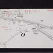
Sorbie motte is rectangular with rounded corners, comprising a raised platform 54ft square with three very well-defined terraces, especially clear on the W side. The motte top is 10ft to 12ft above the ditch below. The first two terraces from the top on the W side are 7ft to 8ft wide, and the third terrace at least 15ft wide to the edge of the ditch. No indication of a bailey can be traced.
W M'Ilwraith 1877; I F MacLeod 1969
A motte generally as described. The ditch can only be traced on the W side.
Revised at 1:2500.
Visited by OS August 1970.
A survey of Sorbie Tower (NX44NE 1) and motte was carried out and a full set of measured drawings has been prepared. Lodged with RCAHMS.
S Wood, C Wood and S Grant 1983
During the first half of July an excavation took place to determine the nature and length of occupation of this motte. Artefacts discovered ranged in date from the 12th to 16th centuries. The base of a flying bridge was evidenced in the ditch bottom.
E Talbot 1983
NX 451 469 In May 1997 a watching brief was conducted of a machine-excavated foundation and soakaway trench for an extension at the rear of Sorbie Tower cottage. The fill(s) and outer edge of the motte ditch along the E side of the mound of the motte were exposed at a truncated level in the bottom of the main trench at the SW end. The curving line of the outer E edge of the ditch was recognised in the natural red boulder clay bottom of the trench; the motte ditch on the SE side of the mound is estimated to be c 7.5m wide at the top level of the outer side of the ditch.
The NW section of the trench suggested that there may have been clay and possibly stone used to line or construct a late phase of the E wall of the ditch. More information suggests that a filled hollow, 1.7m wide, in the outside upper edge of the ditch may have been the back side of a counter enscarpment-like construction of an earlier wider phase of the ditch. This suggests that there may have been a bank outside of the ditch on the E initially. It is also thought that the traditional access across the ditch to the top of the motte was from the NE side of the ditch.
Three finds were found in the fill of the motte ditch: a frilled base sherd (two joining); abraded green glaze; ?14th century, or more likely of early post-medieval date. A sherd; abraded green/brown glaze; most likely of 14th-century date. Bottle glass; short neck with string rim fragment; dark green globose body type wine bottle of c 1698 date.
The excavation cut into a small area of the 1996 geophysical survey of the site, which has influenced the above interpretation.
A fuller report has been deposited with the NMRS.
Sponsor: Sorbie Tower Conservation Project Committee of the Clan Hannay Society.
P Harrington 1997.
Project (October 1996)
NX 450 470 A geophysical survey was carried out in October 1996, commencing with an archaeological subsoil evaluation of the site. This evaluation is being used to compose a research strategy for the site, with an objective to open and present it more fully to the visitor.
Traces were indicated of a structure on the top of the motte, a bailey, and other features on the approach to the tower and motte from the NE. Two areas were surveyed using resistivity and magnetometry, with some useful results.
Sponsor: Clan Hannay Society.
P Harrington 1996
Magnetometry (October 1996)
NX 450 470 A magnetometry survey was carried out in October 1996, commencing with an archaeological subsoil evaluation of the site.
Sponsor: Clan Hannay Society.
P Harrington 1996
Earth Resistance Survey (October 1996)
NX 450 470 A resitivity survey was carried out in October 1996, commencing with an archaeological subsoil evaluation of the site.
Sponsor: Clan Hannay Society.
P Harrington 1996

