
Pricing Change
New pricing for orders of material from this site will come into place shortly. Charges for supply of digital images, digitisation on demand, prints and licensing will be altered.
Several Hill


Archaeological Landscape (Prehistoric) - (Medieval)
Site Name Several Hill
Classification Archaeological Landscape (Prehistoric) - (Medieval)
Alternative Name(s) East Galdenoch
Canmore ID 78932
Site Number NX15NW 78
NGR NX 10848 55988
NGR Description Centred NX 10848 55988
Datum OSGB36 - NGR
Permalink http://canmore.org.uk/site/78932


- Council Dumfries And Galloway
- Parish Stoneykirk
- Former Region Dumfries And Galloway
- Former District Wigtown
- Former County Wigtownshire
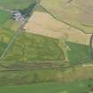
NX15NW 78.00 centred 108 560
NX15NW 78.01 NX 1086 5613 Enclosure
NX15NW 78.02 NX 108 561 Enclosure
NX15NW 78.03 NX 1081 5607 Enclosure: palisaded; Cropmarks
NX15NW 78.04 NX 108 560 Enclosures (possible); Pits
NX15NW 78.05 NX 107 560 Enclosures (possible); Cropmarks
NX15NW 78.06 NX 106 559 to NX 109 558 Linear Cropmarks
Aerial photography has revealed a number of cropmarks in a field to the SW of Several Hill, about 300m ENE of East Galdenoch.
Information from RCAHMSAP (RHM) 8 June 1994
Scheduled as East Galdenoch, enclosures 450m NE of.
Information from Historic Scotland, scheduling document dated 13 December 2000.
Aerial Photographic Transcription (13 March 1993 - 21 October 1993)
An aerial transcription was produced from oblique aerial photographs. Information from Historic Environment Scotland (BM) 31 March 2017.
Aerial Photographic Transcription (7 December 2011)

