
Pricing Change
New pricing for orders of material from this site will come into place shortly. Charges for supply of digital images, digitisation on demand, prints and licensing will be altered.
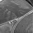
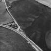
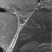
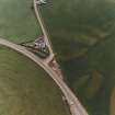
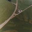
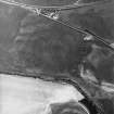
Ballantrae Bridge


Cropmark(S) (Period Unknown), Pit(S) (Period Unassigned)
Site Name Ballantrae Bridge
Classification Cropmark(S) (Period Unknown), Pit(S) (Period Unassigned)
Canmore ID 142403
Site Number NX08SE 33
NGR NX 08691 82008
NGR Description Centred NX 08691 82008
Datum OSGB36 - NGR
Permalink http://canmore.org.uk/site/142403


- Council South Ayrshire
- Parish Ballantrae (Kyle And Carrick)
- Former Region Strathclyde
- Former District Kyle And Carrick
- Former County Ayrshire
NX08SE 33 0869 82008 Centred NX 08691 82008
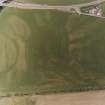
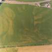
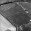
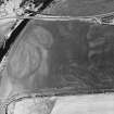
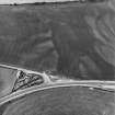
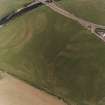
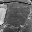
Oblique aerial photographs (RCAHMSAP 1995) have revealed the cropmarks of a large number of pits in the NW end of a field, 200m SW of Ballantrae Bridge (NX08SE 25). Divided into three areas, the first ( NX c.08465 8205) aligned from W to E, measures about 80m. The second area (NX c.0865 8205), aligned from WSW to ENE, measures approximately 180m. The third and largest area of pits (NX 0860 8200), from SW to NE, measures about 200m. The large number of pits suggest that this is a group of possible inhumation burials. In addition there are a large number of other cropmarks situated in the surrounding area (see NX08SE 32, NX08SE 34, NX08SE 35, NX08SE 36 ).
Information from RCAHMS (KJ) 16 March 1999.
Aerial Photographic Transcription (21 October 2011)

