
Scheduled Maintenance
Please be advised that this website will undergo scheduled maintenance on the following dates: •
Tuesday 3rd December 11:00-15:00
During these times, some services may be temporarily unavailable. We apologise for any inconvenience this may cause.
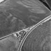
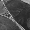
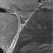
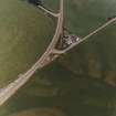
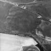
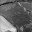
Ballantrae Bridge


Enclosure (Period Unassigned)(Possible), Field Boundary(S) (Period Unassigned), Rig And Furrow (Medieval) - (Post Medieval)
Site Name Ballantrae Bridge
Classification Enclosure (Period Unassigned)(Possible), Field Boundary(S) (Period Unassigned), Rig And Furrow (Medieval) - (Post Medieval)
Canmore ID 142402
Site Number NX08SE 32
NGR NX 08600 82019
NGR Description Centred NX 08600 82019
Datum OSGB36 - NGR
Permalink http://canmore.org.uk/site/142402


- Council South Ayrshire
- Parish Ballantrae (Kyle And Carrick)
- Former Region Strathclyde
- Former District Kyle And Carrick
- Former County Ayrshire
NX08SE 32 08600 82019 centred 08600 82019
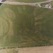
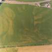
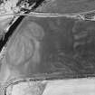
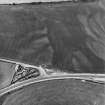
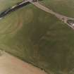
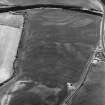
Oblique aerial photographs (RCAHMSAP 1995) show the cropmarks of field boundaries, immediately SW of Ballantrae Bridge (NX08SE 25), in the N end of a field. One is visible from about 200m across the field, aligned NE-SW. Forming an angle is a further linear cropmark running NW to SE for 110m. At a tangent is a curved cropmark, aligned SW-NE. A number of linear cropmarks (NX c.0862 8201) are situated 50m SE of the field boundaries and also immediately to the NW. Some sections of the field boundaries are depicted on the 1st edition of the OS 6-inch map (Ayrshire, 1857, sheet LXV).
Information from RCAHMS (KJ) 15 March 1999.
Aerial Photographic Transcription (21 October 2011)

