
Pricing Change
New pricing for orders of material from this site will come into place shortly. Charges for supply of digital images, digitisation on demand, prints and licensing will be altered.
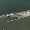
Stranraer Harbour, Ross Pier, Ro-ro Bridge


Bridge (Period Unassigned)
Site Name Stranraer Harbour, Ross Pier, Ro-ro Bridge
Classification Bridge (Period Unassigned)
Alternative Name(s) East Pier; Railway Pier; Ship Ferry Vehicular Terminal, Linkspan; Stranraer Ferry Terminal
Canmore ID 93574
Site Number NX06SE 33.02
NGR NX 06172 61237
Datum OSGB36 - NGR
Permalink http://canmore.org.uk/site/93574


- Council Dumfries And Galloway
- Parish Stranraer
- Former Region Dumfries And Galloway
- Former District Wigtown
- Former County Wigtownshire
NX06SE 33.02 06172 61237
Loading Berth [NAT] (at NX 06150 61254)
Loading Ramp [NAT] (at NX 06211 61190)
OS (GIS) MasterMap, July 2009.
Formerly entered as NX06SE 95.
For associated terminal building (NX 06245 61233), see NX06SE 33.04.
Link span bridge for Ro-Ro ferries, situated on Ross Pier immediately W (and part of) of the East Pier.
(Undated) information in NMRS.

