
Pricing Change
New pricing for orders of material from this site will come into place shortly. Charges for supply of digital images, digitisation on demand, prints and licensing will be altered.
Upcoming Maintenance
Please be advised that this website will undergo scheduled maintenance on the following dates:
Thursday, 9 January: 11:00 AM - 3:00 PM
Thursday, 23 January: 11:00 AM - 3:00 PM
Thursday, 30 January: 11:00 AM - 3:00 PM
During these times, some functionality such as image purchasing may be temporarily unavailable. We apologise for any inconvenience this may cause.
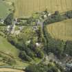
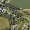
Chirnsidebridge, Paper Mill, Settling Tanks And Filter Beds


Filter Bed (19th Century), Settling Tank (19th Century)
Site Name Chirnsidebridge, Paper Mill, Settling Tanks And Filter Beds
Classification Filter Bed (19th Century), Settling Tank (19th Century)
Alternative Name(s) Chirnside Bridge
Canmore ID 296969
Site Number NT85NE 61.04
NGR NT 85123 56428
Datum OSGB36 - NGR
Permalink http://canmore.org.uk/site/296969


- Council Scottish Borders, The
- Parish Edrom
- Former Region Borders
- Former District Berwickshire
- Former County Berwickshire
NT85NE 61.04 85123 56428
Group of nine filter beds or settling tanks situated to the N of the paper mill on the opposite bank of the Whiteadder Water. Orginally linked to the mill by a small railway viaduct which carried a siding off the Reston to St Boswells railway. The viaduct or bridge survives.
The filter beds are first depicted on the 2nd edition of the OS 25-inch map (Berwickshire, 1898-1899), the current |OS digital maps show a new building on the SW side.
Information from RCAHMS (DE), November 2008

