
Pricing Change
New pricing for orders of material from this site will come into place shortly. Charges for supply of digital images, digitisation on demand, prints and licensing will be altered.
Bass Rock, Castle


Castle (Medieval)
Site Name Bass Rock, Castle
Classification Castle (Medieval)
Alternative Name(s) The Bass; Bass Castle
Canmore ID 57844
Site Number NT68NW 1
NGR NT 6020 8727
Datum OSGB36 - NGR
Permalink http://canmore.org.uk/site/57844


- Council East Lothian
- Parish North Berwick
- Former Region Lothian
- Former District East Lothian
- Former County East Lothian
NT68NW 1 6020 8727
For superimposed lighthouse, see NT68NW 3.
(NT 6020 8727) Castle (NR) (rems of)
(NT 6021 8719) Crane Bastion (NR)
OS 6" map (1971)
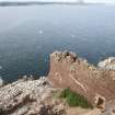
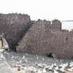
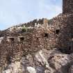
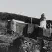
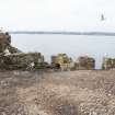
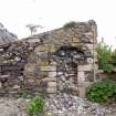
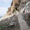
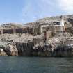
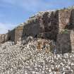
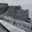
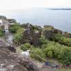
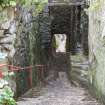
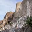
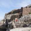
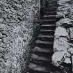
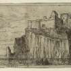
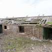
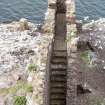
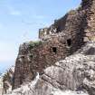
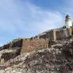
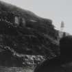
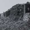
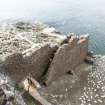
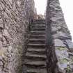
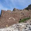
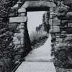
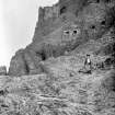
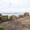
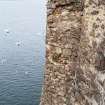
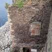
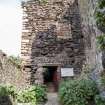
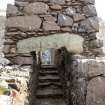
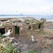
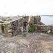
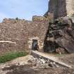
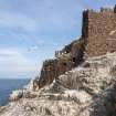
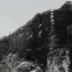
Bass Castle: Access to the Bass Rock is by a landing at the SW corner and the long screen wall of the castle, on average 40ft in height, occupy a terrace above this landing, cutting it off from the remainder of the rock. A battlemented wall projects at right angles from the screen wall (see plan); this has an internal stair with gun ports covering the approach, and ends at the rock edge with a round battery whose ports command the landing place. (This battery is named the Crane Bastion on a plan of about 1700, the crane, used for raising supplies to the castle, being indicated a short distance away). At the N end, a gateway leads past a bastion to a projection in the main screen where an entrance gives access to a long stair. On the S side are the remains of a turnpike stair to the wall-head, and on the N, a single range of rooms. The screen wall continues, incorporating a little room known as Blackadder's Lodging (John Blackadder, minister of Traquair, was one of the Covenanters imprisoned here in the late 17th century), till its final bastion merges into the cliff. Underneath Blackadder's room is a well chamber.
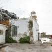
This work is built of local stone, with occasional dressings of imported freestone, and it is dated by the RCAHMS to the 16th century (though an earlier 'Castell of the Bas' is mentioned in 1405). At that time (i.e. 16th century) it belonged to the Lauders of Bass, passing to the Crown in 1671 and to Sir Hew Dalrymple of North Berwick in 1706. In 1902 the E part of the screen wall was pointed and given a flat-topped profile, and the lighthouse built above it (on the site of the governor's house).
RCAHMS 1924, visited 1920; C McWilliam 1978; J Reid 1886; Trans Roy Hist Soc 1895
The remains of the Castle are in good condition, the walls being approximately 4ft thick.
Visited by OS Reviser (DAD) 29 June 1952
Dickson 1899 The Bass rock pp 151-240.
Site recorded by GUARD during the Coastal Assessment Survey for Historic Scotland, 'The Firth of Forth from Dunbar to the Coast of Fife' 1996.
Field Visit (9 July 1920)
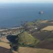
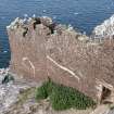
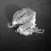
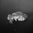
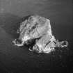
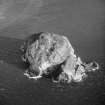
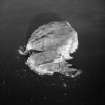
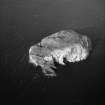
The stock of trachyte known as the Bass Rock in the estuary of the Forth, slightly over 3 miles east-north-east of North Berwick and 1 ¼ miles from the shore, is a natural strength that required but little artifice to make it unassailable. The rock rises almost sheer on all sides but the south to a height of 350 feet above the sea. The process of denudation has resulted in a steep but ascendable western slope from base to crest and in the formation of terraces or rather ledges in the rock. The landing is on a low spur of rock at the south-east corner, and the fortifications may be summarised as screen walls, lodged on the terraces, shutting off this landing from the remainder of the rock (fig. 110). The remains which exist are of 16th century date, and are built in rubble of the traprock of the site with an admixture of imported light coloured freestone in the dressings. Facing south-south-west, a great screen wall, averaging 40 feet in height, returns just above the 100 feet contour line between the cliffs on east and west at a distance of 100 feet back from the southern brink; from this wall a second, disposed almost rectangularly to the first, returns in a southerly direction on the slope to the edge of the cliff (fig. 108). These walls are surmounted by parapets crenellated for guns, and the first mentioned terminates at its western end in an angular projecting battery. A half-moon battery, with a low vaulted under chamber fitted with gun ports, is placed at the lower level of the cliff verge at the southern end of the other wall; the higher wall alone has salient projections.
From the landing there is rough walking over the uneven surface of the rock to an entrance in the east screen wall, and 79 feet inwards from this lies the return of the southern screen, within which is an enclosure 17 feet long and 15 feet wide before the gable of the residential portion. This latter is a structure of two storeys and a garret; below the lowest storey a pended staircase ascends to the higher level of the terrace beyond. The freestone jambs and lintels of the entrance to the dwelling are chamfered, but the only other moulded feature is the fragmentary fireplace on the lowest floor, which has moulded jambs and head, the latter slightly ogival in form. Beyond this structure to the west, there are against the back of the terrace the ruins of a range of two storeyed buildings, which, with the little chamber opposite formed in a projection of the screen wall, housed the Covenanting prisoners in the last quarter of the 17th century. In this latter dwelling was lodged John Blackadder, minister of Traquair, who died in confinement here at the age of 70. Although tiny, measuring only 8 feet 2 inches by 10 feet 9 inches, it has been a not unpleasant chamber, being furnished with fireplace, windows and a door opening out on the parapet walk. Beneath it is an irregularly shaped well of masonry about 6 feet in diameter, which has a present depth of 8 feet. It is provided with a door opening on the open passage between the screen and the structures at the back of the terrace. This well is popularly held to have been a bottle dungeon for the incarceration of refractory prisoners, but the suggestion is not borne out by the remains. Where the modern lighthouse stands was the site of the Governor's House. The parapetted screen wall before it is contemporary with the remainder of the castle.
Two views of the structures on the Bass are given in Slezer's Theatrum Scotiae, plates 56 and 57. A view and plan of the place in c.1700 is reproduced in [RCAHMS 1924] fig. 109.
The ruins are in a bad state of preservation.
HISTORICAL NOTE. On the Lauders of the Bass see Introd. p. xxii. In 1338 Alexander de Ramsay in a boat from the Bass ran the blockade of Dunbar Castle (1). In March 1405 Prince James, on his way to France, went by boat from North Berwick to ‘the Castell of the Bas,’ where he waited for a ship from Leith and thence sailed to his capture off the Yorkshire coast (2). On his return nineteen years later King James committed Walter Stewart, eldest son of the Duke of Albany, to 'close custody' in the same place (3). In 1548-9 the Bass came within the range of the English and Franco-Scottish operations about Haddington and was summarily described by Jean de Beaugue, the historian of these events. This writer notes how there was but one landing, which was on the castle side and very difficult, so that it could be approached by small boats only, one at a time. Moreover there was no safe footing till one got to the castle wall, so that messengers to the captain had first a rope thrown to them to help them in ascending and then, on reaching the foot of the wall, were drawn up in a large basket. This was then the only way of entering the castle. There had been a postern, but at that time it was utterly ruined and unserviceable (4). A royal confirmation of a grant of 1635 specifies ‘the north side of the island and rock of the Bas with the towers’. When equipped with guns the Bass could be a menace to enemy traffic by sea (5). At the time of Cromwell's invasion of Scotland it was held against him on behalf of the laird of Waughton (6), and on 11 January 1651 an English vessel - the John of London, 265 tons burden - bound for Leith, with supplies including ‘Cromwell's two trunks’ was taken by ‘the Capitane of the Basse’, the capture being on the English side attributed to the ‘wilful cowardice of the master’, who yielded ‘upon the shot of a piece or two from the Bass and Tomtallan’ (7). In 1671 the Bass was purchased for the Crown, and the castle became a State prison, most of the occupants in this capacity at the time being Covenanters. The great event in the history of the fortress was when four Jacobite officers confined there in 1691 managed to surprise the place, got rid of the keepers and held the fortress for King James for nearly three years. In 1701 the place was dismantled and the ordnance removed (8).
RCAHMS 1924, visited 9 July 1920.
(1) Cf. RCAHMS 1924 Art. No. 36; (2) Scotich. Lib. xv., cap. xviii.; Wyntoun Bk. ix. chap. 23; (3) Scotich. Lib. xvi., cap. ix.; (4) Histoire de la Guerre d'Ecosse, p. 121; (5) Cf. RCAHMS 1924 Art. No. 106; (6) Cf. RCAHMS 1924 Introd. p. xxxi; (7) Balfour's Annales, iv p. 241; Cromwell's Scotch Campaigns, p. 251; (8) NewStat. Acct.
Reference (1996)
Dickson 1899 The Bass rock pp 151-240.
Site recorded by GUARD during the Coastal Assessment Survey for Historic Scotland, 'The Firth of Forth from Dunbar to the Coast of Fife' 1996.

