
Crailing House, Stables


Stable(S) (Period Unassigned)
Site Name Crailing House, Stables
Classification Stable(S) (Period Unassigned)
Canmore ID 134211
Site Number NT62SE 60.02
NGR NT 68798 24490
Datum OSGB36 - NGR
Permalink http://canmore.org.uk/site/134211


- Council Scottish Borders, The
- Parish Crailing
- Former Region Borders
- Former District Roxburgh
- Former County Roxburghshire
NT62SE 60.02 68798 24490
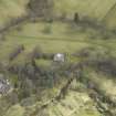
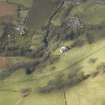
Crailing House, stables are visible on vertical air phtographs (OS 68/008, 085 and 123, flown 1968). The stables are depicted as roofed on the current chart copy of the OS 1:10000 map, (1974)
Information from RCAHMS, September 1994
Sbc Note
Visibility: This is an upstanding building.
Information from Scottish Borders Council.

