
Pricing Change
New pricing for orders of material from this site will come into place shortly. Charges for supply of digital images, digitisation on demand, prints and licensing will be altered.
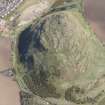
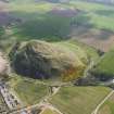
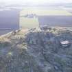
North Berwick Law


Graffiti (Modern), Observation Post (First World War)(Possible), Observation Post (Second World War)
Site Name North Berwick Law
Classification Graffiti (Modern), Observation Post (First World War)(Possible), Observation Post (Second World War)
Canmore ID 73937
Site Number NT58SE 65
NGR NT 55610 84239
Datum OSGB36 - NGR
Permalink http://canmore.org.uk/site/73937


- Council East Lothian
- Parish North Berwick
- Former Region Lothian
- Former District East Lothian
- Former County East Lothian
NT58SE 65 55609 84242
A World War I concrete observation post.
(Undated) information in NMRS.
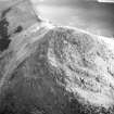
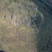
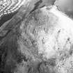
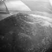
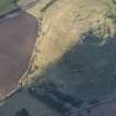
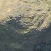
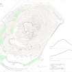
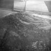
World War One and Two observation post are situated near the summit, on the N side of North Berwick Law.
Of brick and concrete construction, the single storey building is near the remains of an older observation post.
J A Guy 1997; NMRS MS 810/5, 186-8.
Project (March 2013 - September 2013)
A project to characterise the quantity and quality of the Scottish resource of known surviving remains of the First World War. Carried out in partnership between Historic Scotland and RCAHMS.
Field Visit (4 May 2018)
This wartime observation post is situated immediately to the NW of the summit of North Berwick Law, on a site with extensive views to the NW across the Firth of Forth. Rectangular on plan, with a slightly narrower porch at the SW end, the building measures about 7.8m from NE to SW by 4.5m transversely over cement-rendered brick cavity walls 0.4m thickness: the bricks were made by Dougal of Winchburgh, and those used for the jambs have rounded corners. The gently sloping roof is cast in mesh-reinforced concrete and supported on a central I-beam, set onto a vertical I-beam at the front, with a damp-proof course between the roof and the walls.
A doorway at the SW end of the NW wall leads through a small porch, lit by a window and furnished with a storage space. Beyond this there is a large room with a long window opening in the front wall that returns along each side wall. Internal features include two ventilation shafts set about 0.5m high in the rear wall that rise obliquely to openings in the roof above. A circular hole in the roof at the E corner is clearly secondary, and presumably indicates the position of a stove. A conduit for electric cable runs out of the W wall. The walls bear a number of graffiti, most of which is later in date. One example on the external NE wall includes the date ‘1933’ set into the render, perhaps indicating the date of construction or simply of the render itself. Two short fragments of mortared brick of a similar character were also located on the date of visit, one 20m to the NE and the other 25m to the NW. Two metal stanchions were identified 9m to the W and 19m to the S, respectively.
The building is first depicted on the 1948 edition of the OS 25-inch map (Haddingtonshire Sheet II.12), revised in 1938. It may have been constructed during or after World War 1, and was also used in World War 2 (Ferrier 1980, 63).
Visited by HES Survey and Recording (GFG, ATW, AM) 4 May 2018.
(NBL5)

