
The Chesters, Drem


Ring Ditch House (Later Prehistoric)
Site Name The Chesters, Drem
Classification Ring Ditch House (Later Prehistoric)
Alternative Name(s) Dalvreck
Canmore ID 56322
Site Number NT57NW 48
NGR NT 51100 78057
Datum OSGB36 - NGR
Permalink http://canmore.org.uk/site/56322


- Council East Lothian
- Parish Athelstaneford
- Former Region Lothian
- Former District East Lothian
- Former County East Lothian
NT57NW 48 51 NT100 78057
Scheduled (with NT57NW 46, NT57NW 50, NT57NW 86 ) as Dalvreck, ring ditch.
Information from Historic Scotland, scheduling document dated 16 December 1993.
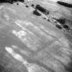
The cropmark of a ring-ditch measuring about 9m in diameter has been revealed by aerial photography 480m ESE of Dalvreck farmsteading. The cropmarks of two pit-alignments pass to the W and S of the ring-ditch (NT57NW 46 and NT57NW 50 respectively).
Information from RCAHMS (KB) 16 December 1999
Note (27 September 2022)
The location, classification and period of this site have been reviewed.

