
Foster Law


Roundhouse (Later Prehistoric)(Possible)
Site Name Foster Law
Classification Roundhouse (Later Prehistoric)(Possible)
Canmore ID 56319
Site Number NT57NW 45
NGR NT 51006 78606
Datum OSGB36 - NGR
Permalink http://canmore.org.uk/site/56319


- Council East Lothian
- Parish Athelstaneford
- Former Region Lothian
- Former District East Lothian
- Former County East Lothian
Archaeological Evaluation (November 2002 - July 2003)
The Traprain Law Environs Project is investigating the settlement and economy of the landscape around Traprain Law during the 1st millennia BC and AD. Since 2000, geophysical surveys have been conducted on 30 neighbouring cropmark sites, which have been followed up by a series of evaluation trenches and open-area excavations.
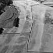
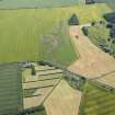
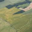
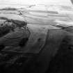
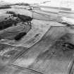
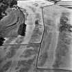
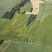
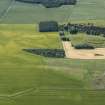
(NT 507 786) Foster Law. Two ditch circuits enclosing a small hilltop at 65m OD, 4km N of Haddington; Chesters hillfort lies 200m to the S. Part of the hilltop was removed by small-scale quarrying during the 1970s. Two evaluation trenches were excavated across the ditches on the northern side and over the ditch terminals at the western end of the site. The outer ditch was the smaller of the two (2.4m wide, 1m deep), and appears to have been recut before being replaced by the more substantial inner ditch (4m wide, 1.5m deep). The upper levels of the inner ditch contained late prehistoric pottery and animal bone, as did layers overlying both ditches.
Archive to be deposited in the NMRS.
Sponsors: HS, British Academy, Society of Antiquaries of Scotland.
P Carne, D Hale and C Haselgrove 2003
Note (27 September 2022)
The location, classification and period of this site have been reviewed.
Aerial Photographic Interpretation (27 September 2022)
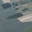
What may be a later prehistoric roundhouse has been recorded as cropmarking on oblique photographs (RCAHMSAP 2015, 2017) on the NE facing slope of Foster Law. It is visible as a subcircular dark mark measuring about 8m in diameter. A pit alignment, probably representing a prehistoric land division, has been recorded immediately to the W (NT57NW 49) while three further roundhouses have been recorded as ring ditches 70m to the W (NT57NW 199) and 115m and 200m to SE (NT57NW 189).
Information from HES Archaeological Survey (F. Vermeij) 27 September 2022

