
Pricing Change
New pricing for orders of material from this site will come into place shortly. Charges for supply of digital images, digitisation on demand, prints and licensing will be altered.
The Chesters, Drem


Pit Alignment(S) (Prehistoric)
Site Name The Chesters, Drem
Classification Pit Alignment(S) (Prehistoric)
Canmore ID 150633
Site Number NT57NW 114
NGR NT 50980 78860
NGR Description From NT c. 5094 7885 to NT c. 5110 7889
Datum OSGB36 - NGR
Permalink http://canmore.org.uk/site/150633


- Council East Lothian
- Parish Athelstaneford
- Former Region Lothian
- Former District East Lothian
- Former County East Lothian
NT57NW 114 c. 5098 7883 to c. 5105 7886
See also NT57NW 1, NT57NW 47, NT57NW 49, NT57NW 51, NT57NW 65.
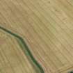
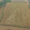
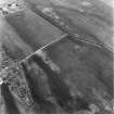
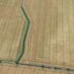
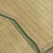
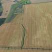
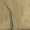
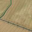
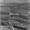
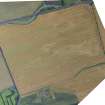
The cropmarks of a closely spaced alignment of pits have been identified from aerial photographs (RCAHMSAP 1995) 620m S of Drem. The alignment runs in an ENE-WSW direction and is visible for approximately 85m from NT c.5098 7883 to NT c.5105 7886. A series of pit-alignments have been recorded around The Chesters fort (NT57NW 1) to the S including NT57NW 46 and NT57NW 49 -52 and 114.
Information from RCAHMS (KB) 15 December 1999
Note (29 September 2022)
The location, classification and period of this site have been reviewed.
Aerial Photographic Interpretation (29 September 2022)
Two pit alignments, likely representing prehistoric land divisions, have been recorded as cropmarking on oblique aerial photographs (RCAHMPSAP 2015) on gently sloping ground SE of Chesters Fort (NT57NW 1). The first pit alignment extends from ENE to WSW for about 180m. It is joined on its W end by a second, perpendicular, pit alignment, measuring about 160m in length.
Information from HES Archaeological Survey (F. Vermeij) 29 September 2022

