
Pricing Change
New pricing for orders of material from this site will come into place shortly. Charges for supply of digital images, digitisation on demand, prints and licensing will be altered.
East Linton, Phantassie Steading


Farmstead (19th Century)
Site Name East Linton, Phantassie Steading
Classification Farmstead (19th Century)
Alternative Name(s) Phantassie Farm Steading; Phantassie House Policies
Canmore ID 56239
Site Number NT57NE 39
NGR NT 59644 77204
NGR Description Centred NT 59644 77204
Datum OSGB36 - NGR
Permalink http://canmore.org.uk/site/56239


- Council East Lothian
- Parish Prestonkirk
- Former Region Lothian
- Former District East Lothian
- Former County East Lothian
NT57NE 39 centred 59644 77204
See also NT57NE 40.01.
For (associated) Phantassie Dovecot (NT 59682 77404), see NT57NE 13.
For (associated) Phantassie House (NT 59810 77228), see NT57NE 40.00.
For (associated) Phantassie Square (cottages, at NT 59335 770860), see NT57NE 41.
For former windmill (NT c. 597 773), see NT57NE 52.
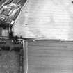
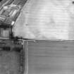
During February 2000, RCAHMS conducted a photographic survey of Phantassie Steading. The purpose of this survey was to enhance and augment the existing holdings of the National Monuments Record Scotland.
Visited by RCAHMS (MKO), November 1999
A long two-storey front built in ashlar with gabled centre and ends, circa 1840.
Information taken from McWilliam, 1978
The formal facade of the courtyard steading is about 240 feet long.
Information taken from Morton, 1976
Mid 19th century quadrangular steading with later additions and modern alterations. S range squared and coursed ashlar; eaves course, raised margins, relieving arches to ground floor windows. Random whinstone rubble with sandstone dressings to rear. S ELEVATION: long front range with central pend; depressed archway in advanced gabled bay with square opening above, and lancet window to gable, now blocked. Decorative finial with weather-vane. 5 bays to flanking ranges; doorways and tall windows at ground, small windows to loft. Ranges terminating in advanced 2-bay gabled wings, 2 windows at ground and 1st floor, lancet window to gable. Long rubble ranges to N and E; doorways at ground floor, windows to loft. Courtyard enclosing cattle courts now modernised. Loft door above entrance pend breaking eaves in piend-roofed gable.
Possibly Peddie and Kinnear. Peddie and Kinnear alterations 1951 (Historic Scotland)
Watching Brief (7 January 2014)
NT 59628 77202 (centred on) A watching brief was undertaken on 7 January 2014 during topsoil stripping associated with the construction of two wind turbine bases. No finds or features of archaeological significance were recorded in either of the two 5 x 5m footprints.
Archive: RCAHMS
Funder: Hamilton Farmers Ltd
Martin Cook and Kevin Paton - AOC Archaeology Group
(Source: DES)

