
Newstead


Temporary Camp (Roman)(Possible), Temporary Camp(S) (Roman)
Site Name Newstead
Classification Temporary Camp (Roman)(Possible), Temporary Camp(S) (Roman)
Alternative Name(s) 'Great Camps' Complex
Canmore ID 55625
Site Number NT53SE 20.05
NGR NT 57400 34100
Datum OSGB36 - NGR
Permalink http://canmore.org.uk/site/55625


First 100 images shown. See the Collections panel (below) for a link to all digital images.
- Council Scottish Borders, The
- Parish Melrose
- Former Region Borders
- Former District Ettrick And Lauderdale
- Former County Roxburghshire
NT53SE 20.05 5740 3410
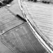
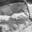
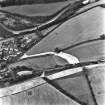
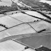
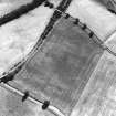
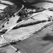
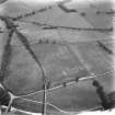
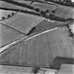
A newly identified camp, between Broomhill Farm and Ravenswood, E of the known complex, and bisected by the A68 road, has an area of a little over 4 acres. The single defensive ditch was 0.83m deep on the W side and 1.44m deep on the S side; a fragment of pottery was recovered, when excavated by J K St Joseph and D Gordon in 1991 and 1993.
L J F Keppie 1994
Aerial Photographic Transcription (14 August 1992)
An aerial transcription was produced from oblique aerial photographs. Information from Historic Environment Scotland (BM) 31 March 2017.
Publication Account (17 December 2011)
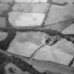
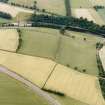
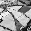
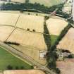
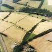
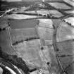
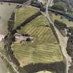
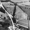
The Roman fort and camps at Newstead lie at the point where Dere Street crosses the River Tweed, just to the north of the three peaks of the Eildon Hills, from which the site gets its Roman name, Trimontium. A branch line from the North British Railway and the A68 both also cross the Tweed at this point.
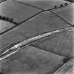
Some seven camps are now known in the vicinity of the fort at Newstead through cropmarks, including two at Ravenswood, with further possible camps in the immediate area as well as at Millmount (see below, possible camps), some 700m west of the fort on low-lying ground by the Tweed. Across the Tweed, between Leaderfoot and Drygrange, another camp has been recorded, lying just west of the now dismantled railway line.
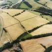
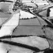
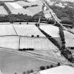
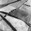
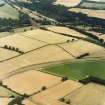
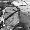
Close to the fort itself, the first camps recorded lie on the ridge to its east (Curle 1911; St Joseph 1958: 87–8). Camp I, originally referred to as ‘The Great Camp’, was subjected to trenching by Curle in 1906–7 and 1909. He recorded a single camp, which he postulated belonged to the 1st century ad, and he did not imply that more than one phase had been found. Since Curle’s excavations, aerial photographs taken since the 1940s have revealed at least three and possibly as many as five camps in this area ( Jones forthcoming 2011 – illus 184). At attempt to entangle the cropmarks from air photographs is made here. Camp I measures 485m by about 435m and enclosed about 21ha (almost 52 acres). Curle recorded four entrances with tituli, three of which can be seen on the air photographs (north-east, south-east and south-west sides). He recorded that the ditch was of varying dimensions, but on average measured some 2.3m in width and 1.5m in depth (Curle 1911: 16). Later excavations in the 1990s recorded a ditch, some 3m in width and 1.8m in depth, which had two phases of use (R F J Jones pers comm). In addition, two Roman cremation burials were found deposited in the south ditch of the camp, which had almost entirely filled up before the burials were cut through, demonstrating that they were therefore later (Curle 1911: 19–20). Three circular hearths were also located in the western part of the camp, but these may be associated with an annexe to the fort because they are within the area where the two overlap (Curle 1911: 18).
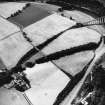
Camp II overlaps camp I and the eastern annexes to the fort, but the relationship between these structures is unknown. The north-eastern side of the camp is in almost the same location as that of camp I, but on a slightly different alignment. The camp measured at least 425m from north-west to south-east by at least 405m, enclosing a minimum of 17ha (42 acres). A probable titulus is visible in its north-east side.
Camp III is probably a reduced form of camp I, with a reduction in its north-west and south west sides. This suggests that it measured around 323m from northwest to south-east by 313m transversely, but is slightly irregular in form. Around 9.6ha (almost 24 acres) is likely to have been enclosed. No entrances are known, but it may have utilised some of the gates of camp I. A further two possible camps are recorded in this area (camps VI and VII).
Recent excavations by Bradford University has suggested that none of the camps in the ‘Great Camps’ complex appears to be earlier than the fort, and at least one has two phases (R F J Jones pers comm).
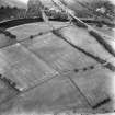
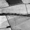
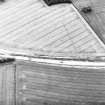
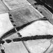
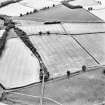
Camp IV lies to the south of the fort, and measures 409m from ENE to WSW by 378m transversely, enclosing 15.5ha (38 acres). A titulus is visible on the ENE side, south of the centre, with possible entrance gaps in the other sides. The eastern sector of the camp is bisected by a linear cropmark representing the east side of camp V, although the relationship between the two is unknown. This camp (V) has been gradually pieced together from different air photographs since the 1950s, with parts of all four sides now identified. It measures some 925m from north to south by around 710m, although appears to be wider at its southern extent than at its northern, and enclosed around 67ha (166 acres). Two entrances protected by tituli are visible on both the east and west sides, and it is assumed that the camp had further gates in the shorter sides adding up to six in total.
The northern part of this camp intersects the southern annexes of the fort. Excavations by Bradford University recorded a V-shaped east– west ditch, measuring 2m in depth and 6m in width (Clarke and Jones 1994), which was not believed to be related to the large camp (R F J Jones pers comm). While these dimensions would make this the largest Roman-camp ditch so far excavated in Scotland, it is not that much larger than the ditches at Burnswark South and Raedykes (1.8m by 5.5m and 2.1m by 4.5m respectively). A single abraded amphora sherd was found in the ditch (Clarke and Jones 1994), and although its location makes it a possible candidate for a further annexe to the fort, the supporting evidence from air photographs does not corroborate this suggestion. Furthermore, a bread oven was also located within this camp. Excavations in the area where the northern part of the east side is believed to run recorded a ditch; it measured 1.5m wide and was 1m deep with steep sides and a flat bottom, which had been cleaned out several times. The excavators interpreted this as having been a large drain ( Jones et al 1992: 14). Further excavations in this area recorded a V-shaped ditch just over 1.5m in width and 1m in depth, but less than halfway across the trench it petered out rather than turn a corner, as would be expected if this were the camp ditch. The ditch was later extended to the north and again had a flat-bottomed steep profile. The excavators believed that these ditches related to land demarcation rather than to this large camp (Jones et al 1993: 18–19). However, an appraisal of the air photographic evidence suggests that some of the excavated ditches are on the line of this large camp.
R H Jones.
Publication Account (17 December 2011)
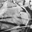
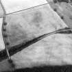
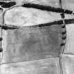
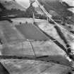
A further two possible camps are visible in the ‘Great Camps’ area to the east of the Roman fort at Newstead, intersecting the known camps (see Newstead I–III). A 225m stretch of cropmark with a rounded corner, which intersects with camp I and the camps at Ravenswood, could represent part of an additional camp at Newstead (VI). Another cropmark, some 175m in length with a rounded corner, which intersects with the north-west side of camp I, may represent part of a further camp (VII), or relate to the eastern annexes of the fort.
R H Jones.

