
Newstead, Eastern Annexe


Fort Annexe (Roman)
Site Name Newstead, Eastern Annexe
Classification Fort Annexe (Roman)
Canmore ID 55624
Site Number NT53SE 20.04
NGR NT 57280 34340
Datum OSGB36 - NGR
Permalink http://canmore.org.uk/site/55624
Ordnance Survey licence number AC0000807262. All rights reserved.
Canmore Disclaimer.
© Bluesky International Limited 2025. Public Sector Viewing Terms
- Correction
- Favourite


SC 1741735
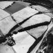
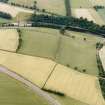
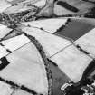
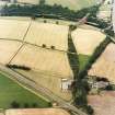
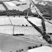
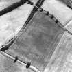
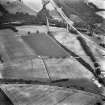
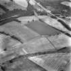
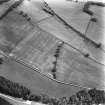
Newstead, Roman fort and temporary camps: air photograph showing Eastern annexe (NT 572 343), annexe (NT 571 343), and 'Great camp' complex of temporary camps (NT 574 341).
RCAHMS Aerial Photography
1988
© Crown Copyright: HES


SC 1741936
Newstead, Roman fort and temporary camps: air photograph showing fort (NT 569 344), Southern annexe (NT 569 341), Eastern annexe (NT 572 343), Western annexe (NT 567 343), annexe (NT 571 343) and possible annexe (NT 570 346).
RCAHMS Aerial Photography
1984
© Crown Copyright: HES


SC 1742049
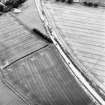
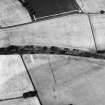
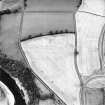
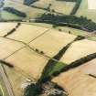
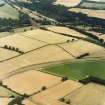
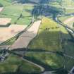
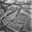
Newstead, oblique aerial view, taken from the WNW, centred on the southern annexe and a temporary camp. The Newstead by-pass (under construction) runs across the photograph.
RCAHMS Aerial Photography
24/7/1995
© Crown Copyright: HES

SC 1742080
Newstead, oblique aerial view, taken from the SSE, centred on the Roman fort eastern annexe and 'great camps' complex.
RCAHMS Aerial Photography
25/7/1996
© Crown Copyright: HES

SC 1742146
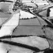
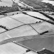
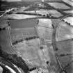
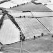
Oblique aerial view of Newstead centred on the cropmarks of the Roman fort, eastern and southern annexes, enclosure and Roman temporary camps, taken from the ESE.
RCAHMS Aerial Photography
11/8/1999
© Crown Copyright: HES

SC 1742164
Oblique aerial view of Newstead centred on the cropmarks of the Roman fort, eastern and southern annexes, enclosure and Roman temporary camps, taken from the SE.
RCAHMS Aerial Photography
11/8/1999
© Crown Copyright: HES

SC 1742183
Oblique aerial view centred on the cropmarks of the eastern and southern annexes of the Roman Fort, taken from the SW.
RCAHMS Aerial Photography
12/7/2000
© Crown Copyright: HES

DP 280750
Oblique aerial view.
Historic Environment Scotland
14/7/2018
© Copyright: HES

SC 1928312
Aerial view
Papers of Professor Dennis W Harding, archaeologist, Edinburgh, Scotland
1978
© Copyright: Professor Dennis W Harding. Courtesy of HES.

DP 019889
Oblique aerial view centred on the cropmarks of the Roman temporary camps and fort annexe, taken from the W.
RCAHMS Aerial Photography Digital
27/7/2006
© Crown Copyright: HES

DP 163841
Oblique aerial view of the cropmarks of the Roman fort at Newstead, looking NE.
RCAHMS Aerial Photography Digital
8/7/2013
© Crown Copyright: HES

DP 277864
Oblique aerial view.
Historic Environment Scotland
10/7/2018
© Copyright: HES

DP 277865
Oblique aerial view.
Historic Environment Scotland
10/7/2018
© Copyright: HES

SC 1741711
Newstead, Roman fort and temporary camps: air photograph showing fort (NT 569 344), Southern annexe (NT 569 341), Eastern annexe (NT 572 343), annexe (NT 571 343), 'Great camp' complex of temporary camps (NT 574 341), and 40-acre and 160-acre temporary camps (NT 570 337 and NT 567 337 respectively).
RCAHMS Aerial Photography
1988
© Crown Copyright: HES

SC 1741716
Newstead, Roman fort and temporary camps: air photograph showing fort (NT 569 344), Southern annexe (NT 569 341), Eastern annexe (NT 572 343), Western annexe (NT 567 343), annexe (NT 571 343), possible annexe (NT 570 346), and 160-acre temporary camp (NT 567 337).
RCAHMS Aerial Photography
1984
© Crown Copyright: HES

SC 1741720
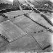
Newstead, Roman fort and temporary camps: air photograph showing Southern annexe (NT 569 341), Eastern annexe (NT 572 343), annexe (NT 571 343) and 'Great camp' complex of temporary camps (NT 574 341). Also shows enclosure at Broomhill (NT 573 342).
RCAHMS Aerial Photography
1984
© Crown Copyright: HES

SC 1741729
Newstead, Roman fort and temporary camps: air photograph showing fort Southern annexe (NT 569 341), Eastern annexe (NT 572 343), annexe (NT 571 343) and 'Great camp' complex of temporary camps (NT 574 343).
RCAHMS Aerial Photography
1988
© Crown Copyright: HES

SC 1741730
Newstead, Roman fort and temporary camps: air photograph showing Southern annexe (NT 569 341), Eastern annexe (NT 572 343), annexe (NT 571 343), and 40- and 160-acre temporary camp (NT 570 337 and NT 567 337 respectively).
RCAHMS Aerial Photography
1988
© Crown Copyright: HES

SC 1741734
Newstead, Roman fort and temporary camps: air photograph showing Southern annexe (NT 569 341), Eastern annexe (NT 572 343), annexe (NT 571 343), and 40- and 160-acre temporary camps (NT 570 337 and NT 570 344 respectively).
RCAHMS Aerial Photography
1988
© Crown Copyright: HES

SC 1741787
Newstead, Roman forts and temporary camps: RCAHMS air photograph showing southern annexe (NT 569 341), eastern annexe (NT 572 343), 'Great camp' complex (NT 574 341), 40-acre temporary camp (NT 570 337) and 160-acre temporary camp (NT 567 337)
RCAHMS Aerial Photography
1976
© Crown Copyright: HES

SC 1741925
Newstead, Roman fort and temporary camps: air photograph showing fort (NT 569 344), Southern annexe (NT 569 341), Eastern annexe (NT 572 343), annexe (NT 571 343), possible annexe (NT 570 346) and 'Great camp' complex of temporary camps (NT 574 341).
RCAHMS Aerial Photography
1984
© Crown Copyright: HES

SC 1741926
Newstead, Roman fort and temporary camps: air photograph showing fort (NT 569 344), Southern annexe (NT 569 341), Eastern annexe (NT 572 343), annexe (NT 571 343), possible annexe (NT 570 346) and 'Great camp' complex of temporary camps (NT 574 341).
RCAHMS Aerial Photography
1984
© Crown Copyright: HES

SC 1741933
Newstead, Roman fort and temporary camps: air photograph showing Eastern annexe (NT 572 343), annexe (NT 571 343), 'Great camp' complex of temporary camps (NT 574 341) and annexe (NT 571 343).
RCAHMS Aerial Photography
1984
© Crown Copyright: HES


SC 1742087
Newstead, oblique aerial view, taken from the NW, centred on the cropmarks of the Roman Fort and Eastern Annexe.
RCAHMS Aerial Photography
25/7/1996
© Crown Copyright: HES

SC 1742089
Newstead, oblique aerial view, taken from the WSW, centred on the cropmarks of the Roman Fort and Western Annexe.
RCAHMS Aerial Photography
25/7/1996
© Crown Copyright: HES

SC 1742094
Newstead, oblique aerial view, taken from the ENE, centred on the cropmarks of the Great Camps Complex.
RCAHMS Aerial Photography
25/7/1996
© Crown Copyright: HES

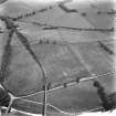
SC 1742119
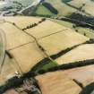
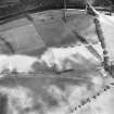
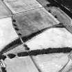
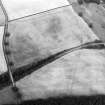
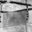
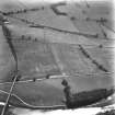
Oblique aerial view centred on the cropmarks of the Eastern Annexe and parts of the northern and western ditches of a temporary camp, taken from the S.
RCAHMS Aerial Photography
17/4/1998
© Crown Copyright: HES

SC 1742144
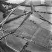
Oblique aerial view of Newstead centred on the cropmarks of the eastern annexe, enclosure and Roman temporary camps with Roman fort adjacent, taken from the SSE.
RCAHMS Aerial Photography
11/8/1999
© Crown Copyright: HES

SC 1742181
Oblique aerial view centred on the cropmarks of the eastern and southern annexes of the Roman Fort, taken from the W.
RCAHMS Aerial Photography
12/7/2000
© Crown Copyright: HES

SC 1742187
Oblique aerial view centred on the cropmarks of the eastern and southern annexes of the Roman Fort, taken from the W.
RCAHMS Aerial Photography
12/7/2000
© Crown Copyright: HES

SC 2449658
Newstead, Eastern Annexe, NT53SE 20.4, Ordnance Survey index card, page number 1, Recto
Records of the Ordnance Survey, Southampton, Hampshire, England
c. 1958
© Crown Copyright: HES (Ordnance Survey Archaeology Division)

SC 1709737
Oblique aerial view centred on the cropmarks of the eastern and southern annexes of the Roman Fort, taken from the SW.
RCAHMS Aerial Photography
12/7/2000
© Crown Copyright: HES


SC 1741934
Newstead, Roman fort and temporary camps: air photograph showing fort (NT 569 344), Southern annexe (NT 569 341), Eastern annexe (NT 572 343) and annexe (NT 571 343).
RCAHMS Aerial Photography
1984
© Crown Copyright: HES


SC 1742079
Newstead, oblique aerial view, taken from the S, centred on the Roman fort eastern annexe and 'great camps' complex.
RCAHMS Aerial Photography
25/7/1996
© Crown Copyright: HES

SC 1742145
Oblique aerial view of Newstead centred on the cropmarks of the eastern annexe, enclosure and Roman temporary camps with Roman fort adjacent, taken from the SE.
RCAHMS Aerial Photography
11/8/1999
© Crown Copyright: HES

SC 1742163
Oblique aerial view of Newstead centred on the cropmarks of the Roman fort, eastern and southern annexes, enclosure and Roman temporary camps, taken from the SW.
RCAHMS Aerial Photography
11/8/1999
© Crown Copyright: HES

SC 1742173
Oblique aerial view of Newstead centred on the cropmarks of the Roman fort, eastern and southern annexes, enclosure and Roman temporary camps, taken from the SW.
RCAHMS Aerial Photography
11/8/1999
© Crown Copyright: HES

SC 2081841
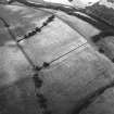
Newstead, Roman fort and temporary camps: oblique aerial photograph showing eastern annexe (NT 572 343) and annexe (NT 571 343).
John Dewar
7/1976
© Copyright: HES (John Dewar Collection)

SC 2449659
Newstead, Eastern Annexe, NT53SE 20.4, Ordnance Survey index card, page number 2, Recto
Records of the Ordnance Survey, Southampton, Hampshire, England
c. 1958
© Crown Copyright: HES (Ordnance Survey Archaeology Division)

DP 019882
Oblique aerial view centred on the cropmarks of the Roman temporary camps and fort annexe, taken from the NE.
RCAHMS Aerial Photography Digital
27/7/2006
© Crown Copyright: HES

DP 019886
Oblique aerial view centred on the cropmarks of the Roman temporary camps and fort annexe, taken from the SE.
RCAHMS Aerial Photography Digital
27/7/2006
© Crown Copyright: HES

DP 019888
Oblique aerial view centred on the cropmarks of the Roman temporary camps and fort annexe, taken from the NW.
RCAHMS Aerial Photography Digital
27/7/2006
© Crown Copyright: HES

DP 163842
Oblique aerial view of the cropmarks of the Roman fort at Newstead, looking N.
RCAHMS Aerial Photography Digital
8/7/2013
© Crown Copyright: HES

SC 1741721
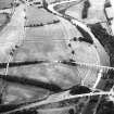
Newstead, Roman fort and temporary camps: air photograph showing Eastern annexe (NT 572 343), Western annexe (NT 567 343), annexe (NT 571 343) and 'Great camp' complex of temporary camps (NT 574 341).
RCAHMS Aerial Photography
1984
© Crown Copyright: HES

SC 1741755
Newstead, Roman fort and temporary camps: air photograph showing Eastern annexe (NT 572 343), Southern annexe (NT 569 341), Western annexe (NT 569 341), annexe (NT 571 343), and possible annexe (NT 569 342).
RCAHMS Aerial Photography
1989
© Crown Copyright: HES

SC 1741759
Newstead, Roman fort and temporary camps: air photograph showing Eastern annexe (NT 572 343), Southern annexe (NT 569 341), Western annexe (NT 569 341), annexe (NT 571 343) and possible annexes (NT 569 342 and NT 570 346).
RCAHMS Aerial Photography
1989
© Crown Copyright: HES

SC 1741788
Newstead, Roman forts and temporary camps: RCAHMS air photograph showing southern annexe (NT 569 341), eastern annexe (NT 572 343), annexe (NT 571 343), 'Great camp' complex (NT 574 341) and 40-acre temporary camp (NT 570 337)
RCAHMS Aerial Photography
1976
© Crown Copyright: HES


SC 1741921
Newstead, Roman fort and temporary camps: air photograph showing Eastern annexe (NT 572 343), annexe (NT 571 343) and 'Great camp' complex of temporary camps (NT 574 341). Also shows pit-alignment and linear feature at Broomhill (NT 576 343 to NT 577 339)
RCAHMS Aerial Photography
1984
© Crown Copyright: HES


SC 1742086
Newstead, oblique aerial view, taken from the NNW, centred on the cropmarks of the Roman Fort.
RCAHMS Aerial Photography
25/7/1996
© Crown Copyright: HES

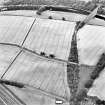
SC 1742117
Oblique aerial view centred on the cropmarks of the Eastern Annexe and parts of the northern and western ditches of a temporary camp, taken from the WSW.
RCAHMS Aerial Photography
17/4/1998
© Crown Copyright: HES

SC 1742143
Oblique aerial view of Newstead centred on the cropmarks of the Roman fort, annexes, and Roman temporary camps, taken from the SW.
RCAHMS Aerial Photography
11/8/1999
© Crown Copyright: HES

SC 1742160
Oblique aerial view of Newstead centred on the cropmarks of the eastern annexe, enclosure and Roman temporary camps with Roman fort adjacent, taken from the NNE.
RCAHMS Aerial Photography
11/8/1999
© Crown Copyright: HES

SC 1742189
Oblique aerial view centred on the cropmarks of the eastern and southern annexes of the Roman Fort, taken from the SW.
RCAHMS Aerial Photography
12/7/2000
© Crown Copyright: HES

DP 019883
Oblique aerial view centred on the cropmarks of the Roman fort, Roman temporary camps and fort annexes, taken from the N.
RCAHMS Aerial Photography Digital
27/7/2006
© Crown Copyright: HES

SC 1741728
Newstead, Roman fort and temporary camps: air photograph showing Southern annexe (NT 569 341), Eastern annexe (NT 572 343), annexe (NT 571 343) and 'Great camp' complex of temporary camps (NT 574 341).
RCAHMS Aerial Photography
1988
© Crown Copyright: HES

SC 1741731
Newstead, Roman fort and temporary camps: air photograph showing Southern annexe (NT 569 341), Eastern annexe (NT 572 343), annexe (NT 571 343), possible annexe (NT 570 346), and 'Great camp' complex of temporary camps (NT 574 341).
RCAHMS Aerial Photography
1988
© Crown Copyright: HES

SC 1741737
Newstead, Roman fort and temporary camps: air photograph showing Eastern annexe (NT 572 343) and 'Great camp' complex of temporary camps (NT 574 341).
RCAHMS Aerial Photography
1988
© Crown Copyright: HES

SC 1741746
Newstead, Roman fort and temporary camps: air photograph showing Eastern annexe (NT 572 343) and 'Great camp' complex of temporary camps (NT 574 341).
RCAHMS Aerial Photography
1988
© Crown Copyright: HES

SC 1741761
Newstead, Roman fort and temporary camps: air photograph showing Eastern annexe (NT 572 343), Southern annexe (NT 569 341), Western annexe (NT 569 341), annexe (NT 571 343), possible annexes (NT 569 342 and NT 570 346), and 160-acre temporary camp (NT 567 337).
RCAHMS Aerial Photography
1989
© Crown Copyright: HES


SC 1741922
Newstead, Roman fort and temporary camps: air photograph showing Eastern annexe (NT 572 343), annexe (NT 571 343), possible annexe (NT 570 346) and 'Great camp' complex of temporary camps (NT 574 341). Also shows enclosure, pit-alignment and linear feature at Broomhill (NT 5734 3422 and NT 576 343 to NT 577 339)
RCAHMS Aerial Photography
1984
© Crown Copyright: HES


SC 1742114
Oblique aerial view centred on the cropmarks of the Eastern Annexe and parts of the northern and western ditches of a temporary camp, taken from the N.
RCAHMS Aerial Photography
17/4/1998
© Crown Copyright: HES

SC 1742118
Oblique aerial view centred on the cropmarks of the Eastern Annexe and parts of the northern and western ditches of a temporary camp, taken from the SSW.
RCAHMS Aerial Photography
17/4/1998
© Crown Copyright: HES

SC 1742142
Oblique aerial view of Newstead centred on the cropmarks of the Roman fort, annexes, and Roman temporary camps, taken from the WNW.
RCAHMS Aerial Photography
11/8/1999
© Crown Copyright: HES

SC 1742159
Oblique aerial view of Newstead centred on the cropmarks of the eastern annexe, enclosure and Roman temporary camps with Roman fort adjacent, taken from the SSE.
RCAHMS Aerial Photography
11/8/1999
© Crown Copyright: HES

SC 1742188
Oblique aerial view centred on the cropmarks of the eastern and southern annexes of the Roman Fort, taken from the WSW.
RCAHMS Aerial Photography
12/7/2000
© Crown Copyright: HES

DP 280749
Oblique aerial view.
Historic Environment Scotland
14/7/2018
© Copyright: HES

SC 2449662
Newstead, Eastern Annexe, NT53SE 20.4, Ordnance Survey index card, page number 5, Recto
Records of the Ordnance Survey, Southampton, Hampshire, England
c. 1958
© Crown Copyright: HES (Ordnance Survey Archaeology Division)

SC 2449664
Newstead, Eastern Annexe, NT53SE 20.4, Ordnance Survey index card, page number 7, Recto
Records of the Ordnance Survey, Southampton, Hampshire, England
c. 1958
© Crown Copyright: HES (Ordnance Survey Archaeology Division)


DP 019874
Oblique aerial view centred on the cropmarks of the Roman fort, Roman temporary camps and fort annexes, taken from the N.
RCAHMS Aerial Photography Digital
27/7/2006
© Crown Copyright: HES

SC 1709736
Oblique aerial view centred on the cropmarks of the eastern and southern annexes of the Roman Fort, taken from the WSW.
RCAHMS Aerial Photography
12/7/2000
© Crown Copyright: HES

SC 1741712
Newstead, Roman fort and temporary camps: air photograph showing fort (NT 569 344), Southern annexe (NT 569 341), Eastern annexe (NT 572 343), annexe (NT 571 343), 'Great camp' complex of temporary camps (NT 574 341), and 40-acre and 160-acre temporary camps (NT 570 337 and NT 567 337 respectively).
RCAHMS Aerial Photography
1988
© Crown Copyright: HES

SC 1741760
Newstead, Roman fort and temporary camps: air photograph showing Eastern annexe (NT 572 343), Southern annexe (NT 569 341), Western annexe (NT 569 341), annexe (NT 571 343), possible annexes (NT 569 342 and NT 570 346), and 160-acre temporary camp (NT 567 337).
RCAHMS Aerial Photography
1989
© Crown Copyright: HES

SC 1741930
Newstead, Roman fort and temporary camps: air photograph showing fort (NT 569 344), Southern annexe (NT 569 341), Eastern annexe (NT 572 343), annexe (NT 571 343), 'Great camp' complex of temporary camps (NT 574 341), and 40-acre and 160-acre temporary camps (NT 570 337 and NT 567 337 respectively).
RCAHMS Aerial Photography
1988
© Crown Copyright: HES


First 100 images shown. See the Collections panel (below) for a link to all digital images.
- Council Scottish Borders, The
- Parish Melrose
- Former Region Borders
- Former District Ettrick And Lauderdale
- Former County Roxburghshire
NT53SE 20.04 5728 3434
NT 5730 3425 Ploughing in late December 1997 lifted to the surface a substantial, roughly dressed, square flag in red sandstone. Photographs were taken and the find made safe and reported. The find itself, though of purposeful shape, is unremarkable on a Roman site. Its location in a far corner of the E annexe may have significance: the find location is at the SE edge of the parade ground area delineated by altar finds, where paved areas, such as a tribune, might be expected (S Clarke, pers comm).
W Lonie 1998
Aerial Photographic Transcription (14 August 1992)
An aerial transcription was produced from oblique aerial photographs. Information from Historic Environment Scotland (BM) 31 March 2017.

