
Pricing Change
New pricing for orders of material from this site will come into place shortly. Charges for supply of digital images, digitisation on demand, prints and licensing will be altered.
Newstead, Southern Annexe


Fort Annexe (Roman), Unidentified Pottery (Roman)
Site Name Newstead, Southern Annexe
Classification Fort Annexe (Roman), Unidentified Pottery (Roman)
Canmore ID 55623
Site Number NT53SE 20.03
NGR NT 56950 34170
Datum OSGB36 - NGR
Permalink http://canmore.org.uk/site/55623


First 100 images shown. See the Collections panel (below) for a link to all digital images.
- Council Scottish Borders, The
- Parish Melrose
- Former Region Borders
- Former District Ettrick And Lauderdale
- Former County Roxburghshire
NT53SE 20.03 5695 3417
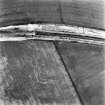
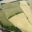
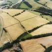
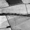
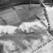
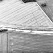
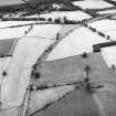
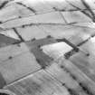
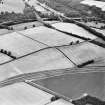
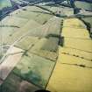
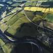
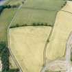
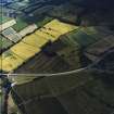
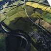
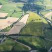
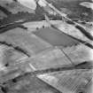
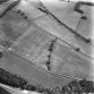
The fifth season of excavation saw the examination of two areas within the S annexe, c.70m S of the S rampart of the fort, straddling the 4m wide road leading from the S gate. To the E of the road, a complex sequence of gullies and metalled surfaces yielded few small finds. To the W of the road, six phases of occupation, all 2nd century AD, were distinguished. The area was given over to industrial activities; furnaces and timber buildings were present and small finds were numerous. A N-S ditch W of the road, previously interpreted from aerial reconnaissance as forming part of one side of a large marching-camp, may have served for drainage or as a land division.
L J F Keppie 1994
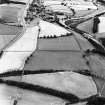
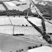
NT 570 341. Excavation in adavnce of the Melrose Bypass (Phase III) examined the sides of the old railway cutting where it passed through the S Annexe of Newstead Roman Fort. Both phases of defensive ditches were examined along with interior occupation, the most important of which were a series of pits (marked A-F on the plan (Clark 1995, fig.1). Several previously unknown roads were also discovered. The earliest defensive line consisting of a single large ditch up to 7m across, was found to date to the late 1st century. The larger double ditched enclosure was found to contain only mid-2nd century pottery, similar to that of the interior occupation. Four of the six pits were found to have served as wells, although only two were lined, one with wattle, the other stone. The latter was found to contain a ritual deposit at its base; horse and cattle skulls, an axe complete with handle, deer antlers and a complete pottery jar. This well's contents are probably relevant to the undertsanding of the 107 deep pits dug by James Curle, 1905 - 1910.
Sponsor: Borders Regional Council.
S Clarke 1995
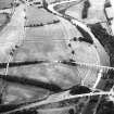
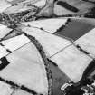
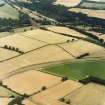
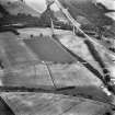
NT 562 340 to NT 572 340 Excavation in advance of the Melrose Bypass (Phase III) showed the examination of a Roman period landscape already known from cropmarks and Geophysics. The largest element examined was part of the so-called legionary marching camp to the SW, partly overlying the S annexe. Ditch lengths excavated at NT 570 341, NT 562 340 and NT 567 342 showed three sides of the 'camp' to be quite different in character, ranging from 1-6m across and 1-2m in depth. These features and another at NT 572 340 seem much more likely to be part of a field system surrounding the fort in the mid-2nd century. Most contained no datable artefacts.
Another ditch at 571 341 does represent a marching camp ditch. It was almost 3m across and 1.7m deep. The only find associated with it was the lower stone of a rotary quern.
Sponsor: Borders Regional Council.
S Clarke 1995
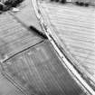
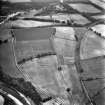
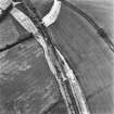
NT 577 340 to NT 553 340 A watching brief was undertaken in June and July 1995 on the construction of the Melrose Bypass Road project. The route is mainly set in agricultural land and directly affects a large area of Scheduled Ancient Monument centred round the Roman Military complex of Newstead. No archaeological features that had not previously been recorded by Bradford University were noted during the watching brief. Two artefact scatters were located, at NT 5690 3415 and NT 5710 3410, both on the southern slope of the railway cutting. The material was located by fieldwalking, where it was eroding from an organic rich matrix exposed by excavation. Both scatters contained sherds of samian ware, mortaria, and othr fine and course wares.
Sponsor: Borders Regional Council through Bradford University.
J Hamilton 1995.
A watching-brief, by CFA during road construction, revealed pottery scatters at NT 5690 3415 and NT 5710 3410.
L J F Keppie 1996
Magnetometry (1990)
Magnetometer and resistivity surveys confirmed the location of two road running S from the fort and suggested the presence of at least 6 strip-buildings along them; one of these appeared to be cut by the ditch of the 163-acre camp (NT53SE 20.07).
S S Frere 1990
Earth Resistance Survey (1990)
Magnetometer and resistivity surveys confirmed the location of two road running S from the fort and suggested the presence of at least 6 strip-buildings along them; one of these appeared to be cut by the ditch of the 163-acre camp (NT53SE 20.07).
S S Frere 1990
Geophysical Survey (1991)
Geophysical survey has located at least 10 burnt buildings.
S S Frere 1991
Aerial Photographic Transcription (14 August 1992)
An aerial transcription was produced from oblique aerial photographs. Information from Historic Environment Scotland (BM) 31 March 2017.
Watching Brief (1995)
Newstead
1995
Melrose Bypass Road Phase III: watching brief
NT 577 340 to NT 553 340. A watching brief was undertaken in June and July 1995 on the construction of the Melrose Bypass Road project. The route is mainly set in agricultural land and directly affects a large area of Scheduled Ancient Monument centred round the Roman Military complex of Newstead. No archaeological features that had not previously been recorded by Bradford University were noted during the watching brief. Two artefact scatters were located, at NT 5690 3415 and NT 5710 3410, both on the southern slope of the railway cutting. The material was located by field-walking, where it was eroding from an organic rich matrix exposed by excavation. Both scatters contained sherds of samian ware, mortaria, and other fine and coarse wares.
Hamilton, J., 1995, Discovery and Excavation in Scotland 1995, CSA
Runs to parish boundary via Melrose and NewtownSt. Boswells. Earlston\Reston\Duns line branchesoff at NT 575 338.

