
Pricing Change
New pricing for orders of material from this site will come into place shortly. Charges for supply of digital images, digitisation on demand, prints and licensing will be altered.
Newstead


Fort Annexe(S) (Roman), Roman Fort (Roman), Temporary Camp(S) (Roman)
Site Name Newstead
Classification Fort Annexe(S) (Roman), Roman Fort (Roman), Temporary Camp(S) (Roman)
Canmore ID 55620
Site Number NT53SE 20
NGR NT 57000 34400
NGR Description Centred NT 57000 34400
Datum OSGB36 - NGR
Permalink http://canmore.org.uk/site/55620


First 100 images shown. See the Collections panel (below) for a link to all digital images.
- Council Scottish Borders, The
- Parish Melrose
- Former Region Borders
- Former District Ettrick And Lauderdale
- Former County Roxburghshire
NT53SE 20.00 centred 570 344
See also NT53SE 93 and NT53SE 95.
For Trimontium Monument (NT 56848 34513), see NT53SE 68.
NT53SE 20.01 NT 569 344 Roman Fort
NT53SE 20.02 NT 567 343 Western Annexe
NT53SE 20.03 NT 569 341 Southern Annexe; Pottery
NT53SE 20.04 NT 572 343 Eastern Annexe
NT53SE 20.05 NT 574 341 Roman Temporary Camps, 'Great Camps' Complex
NT53SE 20.06 NT 570 337 Roman Temporary Camp - 40 acre
NT53SE 20.07 NT 567 337 Roman Temporary Camp - 160 acre
NT53SE 20.08 NT 570 344 Roman Pottery; Glass Bead; Glass Armlet
NT53SE 20.09 NT 569 342 Annexe (possible)
NT53SE 20.10 NT 571 345 Annexe
NT53SE 20.12 NT 570 346 Annexe (possible)
NT53SE 20.13 NT 5650 3435 Ditches; Roman Pottery
NT53SE 20.14 NT 572 341 Pitchstone Blade.
NT53SE 20.15 NT 5707 3427 Iron Point
NT53SE 20.16 NT 571 343 (centred) Intaglio; brooch; iron; spearhead; Samian Ware
(Centred: NT 5710 3439) Trimontium (Roman Fort) (R) (Site of).
OS 6" map (1918-36)
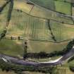
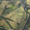
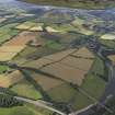
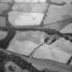
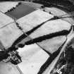
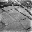
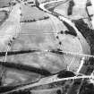
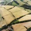
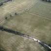
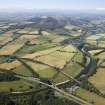
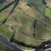
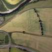
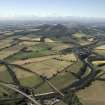
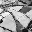
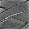
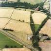
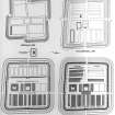
Roman Forts and Temporary Camps, Newstead (Site). Of the Roman forts and temporary camps near Newstead no structural remains survive on the surface of the ground, and everything known about them has been learned by excavation (J Curle 1911; I A Richmond 1952) or by air-photography. Their site lies on the S bank of the Tweed, a mile and a half E of Melrose, on a high bluff just E of the village of Newstead, where Dere Street crossed the river.
The N side of the site is completely protected by the bluff, while on the other sides a shallow trough to the S, now occupied by the main railway-line to Carlisle, and a gentle fall to E and W ensure good immediate dominance of the situation. The westward outlook, up the Tweed valley, is good, but all other vistas are short, as often in a bridge-head site. If, however, the choice of site was partly determined by political considerations, it was the best in the locality.
Once chosen, the site was intensively occupied, and it is now clear that the two main periods distinguished by the late Dr James Curle each contained two phases. There were two Flavian occupations, the first beginning with Agricola in AD 80 and the second ending about AD 100; and two Antonine occupations, the first beginning in AD 140 and the second terminating not later than AD 196. The successive forts occupied the same site throughout, and their structures overlie one another in a tangle which can best be resolved by treating each fort separately.
(i) THE AGRICOLAN FORT, facing westwards and covering 10.6 acres, measures 655 ft. from N to S by 705 ft. from E to W over its rampart, of which the line is staggered at each of the four gates, so that the right or unshielded side of the attacker is exposed. The resultant outline, resembling a swastika with staggered tails, is a highly unusual and difficult piece of castrametation. It is matched in Scotland only at Milton (J Roman Stud vol.39) (Dumfriesshire), where, however, the arrangement appears at two gates only and is illogically designed at one of them. At Newstead the gates themselves remain unexcavated. The rampart, 23 ft thick, was of white beaten clay, resting upon a frontal strip of cobbling 7 ft 6 in wide; and in front of it on every side of the fort lay two ditches, set 10 ft apart and measuring 8 ft to 9 ft in width and up to 5 ft in depth. Behind the rampart was an open space (intervallum) 50 ft wide, a provision for marshalling the defence and placing the buildings of the fort beyond the range of lethal missiles or fire-darts. Little is known of the buildings themselves; they were not observed until recently, when the only structure identified was a timber-framed stable, resting upon timber sole-plates, bordering the south intervallum. The occurrence of such a building, however, implies that the fort was equipped with buildings of at least comparable solidity throughout and that the garrison of this period was not housed, as was once thought, in tents. The stabling attests the presence of cavalry, and the fort is big enough to have held an ala milliaria or two alae quingenariae brigaded together; but no specific information as to the garrison of this period is forthcoming.
The erection of the fort is to be associated with Agricola's northward advance in AD 80. As to its end, in the filling of its obliterated ditches were found two coins (J Curle 1911) of AD 86, in mint condition, which can hardly have been current later than AD 90. These would seem to date the supersession of the first fort to the late eighties.
(ii) THE LATE-DOMITIANIC FORT was erected on the site of the Agricolan fort, of which the rampart and buildings were demolished and the ditches obliterated. In filling the Agricolan ditches the demolition party disposed of a good deal of its own rubbish, including remnants of leather tents, a broken mallet and so forth. The new fort which it then set about building was almost rectangular; it covered 14.3 acres and measured 760 ft. (N to S) by 820 ft. (E to W) over its rampart, which was of clay. This embodied the Agricolan rampart wherever possible and was 45 ft. thick, an enormous width which implies a correspondingly great height, calculable at about 28 ft. The massive vallum was fronted by a new single ditch, well over 16 ft. wide and 7 ft. 6 in. deep.
The scale of these works, so much larger than those of the Agricolan fort, denotes an intention both to settle down on the site and to make it impregnable. Now that the legion at Inchtuthill had departed for Central Europe, Newstead was the largest and most important military position N of the Cheviots, and this is a context in which the scale of its new defences can be understood. Inside the rampart an intervallum some 50 ft. wide was provided, but, as not uncommonly, it was occupied by at least one narrow building, a cook-house or the like. Both this building and the main barracks of the new fort were erected upon stone foundations set in clay, the absence of mortar implying that the stonework represented the low sill-walls of timber-framed wattle-and-daub buildings roofed with shingles or thatch. The known barrack, a twin block measuring 224 ft. long by 57 ft. wide, is exceptionally large for auxiliary troops and probably belonged to legionaries, whose weapons come from pits of this period on the site. On the main cross-street of the fort, which faced westwards, a twin granary (horreum) and the sacellum, or regimental shrine, of a headquarters building (principia) were identified; while in the praetentura, or forward part of the fort, there was noted a single living-room (contubernium) belonging to a barrack-block which consisted of a row of such individual living-quarters. The pits (J Curle 1911) of the period produced both legionary and auxilliary armour, but once more no unit is specifically defined and not enough is known about the number and disposition of barracks or stables in the praetentura to permit an estimate of the accommodation. Outside the W rampart of the fort there was in this period, if not before, a bath-house and, adjoining it, an extendsive courtyard building, resembling a house, which is best explained as a praetorium - a mansio or rest-house for official travellers. It may be compared with the institution (Dessau) of praetoria on the military roads of Thrace under Claudius, and another structure of exactly the same kind has been revealed by air-photography flanking the main road which leaves the N gate of the Flavian fort at Birrens. That this period of occupation ended in disaster there is little doubt. Not only were the buildings set on fire, but the armour and weapons from the pits showed abundant signs of damage. The date of the end is not yet precisely ascertained, but the tentative suggestion of about AD 100 offered above is that which best fits the evidence.
(iii) THE EARLY-ANTONINE FORT was founded on the overgrown ruins of the late-Domitianic rampart, but its vallum, in the then new fashion, was faced externally with a massive stone fort-wall. This enclosed an area of 14.7 acres, measuring 773 ft. (N to S) by 830 ft. (E to W). All that remains of the wall is its foundations, 6 ft. wide by 3 ft. deep, and fragments of a chamfered plinth. There came behind it a rampart 36 ft. wide, backed by ovens situated on an intervallum 29 ft. wide. In front of the fort wall lay two ditches, the outer 6 ft. wide and 3 ft. deep, the inner 8 ft. wide and 3 ft. 6 in. deep, each V-shaped and each with the counterscarp considerably steeper than the scarp. The character of the filling suggested that they were intended to hold entanglements of branches. The outer lip of the outer ditch lay 71 ft. away from the fort wall and that of the inner ditch 33 ft. away, and they were plainly intended to trap attackers in the field of fire best suited to the defenders using hand-missiles.
Inside the fort, which faced E, buildings of this period are known in some detail. The praetentura contains twelve barracks, all divided into eleven living-quarters (contubernia) ten for the men and one for a centurion. The main buildings comprise a large headquarters-building (principia), with the usual colonnaded front courtyard (campus), cross-hall, regimental shrine, and administrative offices for regimental funds and records; two granaries, one of each side of the principia, with porticoes on the via quintana behind them; and a commandant's house, with private bathing-establishment, as at Mumrills. The N end of the row of main buildings remains unexplored, but must have contained, for example, a hospital. The retentura also remains uninformative as regards buildings of this period. It was cut off from the main buildings by a dividing-wall 6 ft. 6 in. wide, matching the fort wall in size and provided with a single gateway flanked by two rectangular projecting towers. The dividing-wall was associated with neither ditch nor rampart-backing and terminated at the rampart-backing of the main fort-wall which enveloped the retentura; though it was here built in different and inferior style.
These arrangements, unique in Britain, are best explained by the fact that the garrison of the period comprised both legionaries and auxiliaries. Thus, the principia yielded an altar dedicated by a centurion of the Twentieth Legion, G Arrius Domitianus, and with it were found both legionary and auxiliary armour, presumably relics from the official armoury of the fort which often lay in the principia. That the legionary centurion was commander of the joint force is further shown by the fact that he dedicated the principal altar in the headquarters building, honouring, as was customary, Jupiter, the patron deity of the Roman army, and also set up altars to deites outside the fort.
The function of the dividing-wall was, then, to separate the two types of unit, and the name of the auxiliary unit is given by another altar, from the parade ground E of the fort, as the ala Augusta Vocontiorum, a calvalry regiment 500 strong. Although none of the barracks or stables of this unit survives, there is in fact exactly room within the walled retentura to contain the eight barracks and eight stables which such a unit required and which have been detected in the forts of similar units (F G Simpson and I A Richmond 1941) on Hadrian's Wall.
To W of the fort the little bath-house of this period also received an enclosing rampart, as if to reserve it for the use of one or other unit.
(iv) THE LATER-ANTONINE FORT came into existence after no long period of disuse, for the early-Antonine ditches were filled up before any noticeable amount of silt had gathered in them. The fort wall was used once more, doubtless with re-building where needed, so that the size and dimensions of the fort thus remain as in the previous period. The width of the rampart-backing, however, was increased to 54 ft., at the expense of the intervallum, which was reduced to a roadway 11 ft. wide. This probably means that cooking and similar operations were now being done upon a shelf cut in the rampart-back itself, but the remains were not preserved to a sufficient height to show this.
Outside the fort wall the ditch system was now re-cut, and comprised three ditches, their outer lips placed at 19 ft., 52 ft., and 86 ft. beyond the wall. These are true V-shaped ditches between 10 ft and 12 ft. wide and approximately 4 ft. deep, and they are plainly intended to check an advance across a field of fire.
Inside the fort the dividing-wall was demolished and the whole of the retentura was now levelled up and filled with stables. The legionary barracks were rebuilt, but, as the liberal provision of stable shows, the garrison was now cavalry, and the twelve barracks of the praetentura are in fact exactly sufficient to accommodate the twenty-four turmae of an ala milliaria. The headquarters building was rebuilt, and received a large hall, 50 ft. wide and 160 ft. long, spanning the via principalis in front of it. It has been suggested that such halls were in fact riding-schools, such as the basilica equestris exercitatoria mentioned in an inscription (Corpus Inscriptionum Latinarium, 7, 965) from Netherby, Cumberland and in Britain the only other known examples (Wheeler; F G Simpson and I A Richmond 1937) at Brecon Gaer and Halton, are associated with cavalry garrisons; but completely convincing proof of identity is not yet forthcoming.
Neither the date of foundation nor the date of evacuation of this latest fort is as yet securely established. As explained in the Introduction (RCAHMS 1956), it seems certain that its beginning was not earlier than AD 158 and its end not later than AD 196, and associated pottery recovered in the fort is consonant with such dating but not susceptible of closer interpretation. The latest coin recorded by Dr Curle is of AD 177.
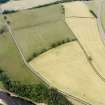
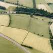
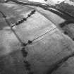
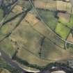
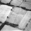
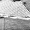
THE ANNEXES. There is no doubt that in each period of occupation the Roman fort at Newstead was furnished with one or more annexes or fortified compounds intended to house camp-followers or afford temporary shelter to convoys. Dr. Curle recognised at least four of these, attached to every side of the fort except the N. and often subdivided; but it was not then possible, in every case, to associate these with given periods. Air-photography, however, has added enough to the general picture for the necessary discrimination to be made.
(i) The W Annexe, of which the main defences comprise at least four ditches and a rampart, was found to be linked first with the ditches of the Agricolan fort and also with the later Antonine phase. It enclosed some 7 acres. In the latter period it was subdivided by an E-W ditch, of which the E half apparently followed an earlier ditch surrounding the baths and their compound and cutting off the later Flavian praetorium adjoining them.
(ii) The E Annexe enclosed over 20 acres. The E end of its N side makes use of part of temporary camp B, and it is shown by air-photography to have been everywhere defended by a double ditch. These ditches continued across the ground later occupied by the S annexe to a point just E of the Agricolan S gateway. Like the W annexe it is presumably Agricolan. The broad single ditch that isolates its W end must be a later development, and may be considered as associated with the large single ditch of the late-Domitianic occupation, if this feature is not really two ditches combined and connected with the early Antonine occupation also.
(iii) The S Annexe, enclosing some 14 1/2 acres, seems to have developed as a subdivided unit from the first. The outer or S half, bounded by a double ditch, goes with the Flavian roadway from the S and was later modified to fit the Antonine road. Air-photography shows that its SE angle was sharper that Curle's plan would suggest. The inner subdivision is similarly related to the roads but looks like a development dating from a time after the Agricolan E annexe had passed out of use, and may itself represent a reduction of the S annexe in the late-Domitianic period.
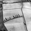
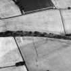
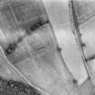
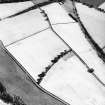
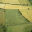
THE TEMPORARY CAMPS. As at Ardoch or Glenlochar, the vicinity of the fort at Newstead was the scene of many troop movements or concentrations, whether for campaigning or engineering. These have left their mark in the form of five large temporary camps, defended by a slight ditch and rampart, in which the troops bivouacked in their lines of leather tents.
The largest of these (RCAHMS 1956, fig.426, A), covering 1590 ft. by 1340 ft. and furnished with four gateways defended by traverses (tutuli), was identified by excavation E of the fort, on the site where the Antonine altar to the Campestres, or goddesses of the parade-ground, was found. An early cremation burial was also found in its S ditch. This, however, was not the only camp on this part of the site. Aerial photography has identified the W side and N side, with tutulus, of a second (B) whose ditch was later in part used for the E annexe of the Flavian fort and determined its odd shape. The same flight revealed the NW angle and part of the adjacent sides of a third camp (C), without in either case disclosing the whole perimeter.
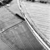
A fourth large camp (D) lay S of the fort, astride the ridge N of the Bogle Burn, of which air-photography has disclosed the SW angle, NE angle, and E side, but as yet no gateway. This work, measuring 1380 ft. by 1300 ft., crosses both the Flavian and Antonine roads leading to the fort from the S and is thus likely to be earlier than either. It occupies much the same site as a fifth camp (E), of which air-photography has so far revealed only the E side, with a gate defended by a tutulus. This camp seems to have lain along the W side of the Antonine road and its SE angle appears to have been eroded by the Bogle Burn.
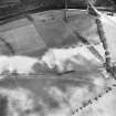
THE ROADSIDE POST. The crest of the ridge N of the Bogle Burn is occupied by a small post (F), measuring 180 ft. square and possessing an outlook southwards which is denied to the main fort. It must have lain very close to the point where Dere Street crossed the ridge on the direct line from Eildon to the Tweed crossing. A trial trench, cut in 1947 by Dr St Joseph, produced a fragment of Flavian Samian ware from the site, but its internal arrangements are otherwise unknown and it is impossible to say whether its purpose was for signalling or for supervision of traffic, to mention the two most obvious possible functions.
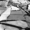
EARTHWORK. Within the SW quadrant of the fourth of the temporary camps mentioned above, and on the same ridge as is occupied by the roadside post, air-photography has revealed the S half of an earthwork possibly a native fort. No remains are visible on the ground, but the air-photographs suggest that it was a double-ditched, broadly-oval work measuring about 360 ft. by 330 ft. over all.
THE SITE IN POST-ROMAN TIMES. Even when abandoned by their builders, the Roman ruins at Newstead seem to have retained some kind of shadowy significance. That the area was inhabited in post-Roman times is proved by the occurrence of Roman dressed stones in an earth-house (RCAHMS 1956, No.611). Again, Professor R S Loomis (1949) notes that about 1220 Guillaume le Clerc, in the Fergus romance, identified "Mont Dolerous" with the mountain of Melrose and located on it a castle overhanging a deep river; and he accepts a suggestion that the poet may have had in mind the remains of the Roman fortifications, still conspicuous in his day.
In the 18th century the site was supposed to be that of an abbey and was known as "Red Abbey-steed" (A Milne 1743), a name perpetuated as "Redabbey Stead" on the second edition (1899) of the 6-inch OS map.
RCAHMS 1956, visited 1947
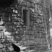
A number of carved stones and altars have been discovered in and around the Forts and Camps and are described by the RCAHMS. Four altars and two stones, together with a cast of a third are in the National Museum of Antiquities, Edinburgh, and one of the stones is in the Melrose Abbey Museum.
Information from OS Recorder (DT) 26 February 1957
Among other finds made on the surface of the fort in 1966 were two second brass of Antoninus Pius, which were retained by the finder; and a sestertius of Trajan was donated to the National Museum of Antiquities of Scotland (NMAS) in 1966.
J Elliot 1966; Proc Soc Antiq Scot 1967
There are at least three camps to the east of the fort.
Information from J K St Joseph 8 April 1978
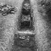
Magnetometer survey and exploratory excavations were undertaken in the SW part of the Fort, to the W of the so-called 'reducing' or 'dividing' wall; in order to investigate indications of industrial activities from surface finds.
Field walking over several years by Walter Elliot has produced from this part of the site a variety of finds, including the wasters and metal working slags. The magnetometer survey showed a complex picture suggesting intense activity. The most substantial magnetic anomaly was of a magnitude and size to suggest a kiln. Excavation in the area of this feature in fact showed it to be a very dense bank of magnetic iron slag, part of a substantial smithing occupation. An area 10 by 10m was opened, but only the upper levels of a complex stratification could be excavated in the time available. The earliest feature identified was a deposit of heavy cobbles set in grey clay, exposed in a field drain trench and extending over an area of several square metres at least.
Its nature could not be established in this excavation.
The major phase examined consisted of a series of iron smithing hearths set in a complex accumulation of iron working debris. In one part there was a sequence of at least six hearths superimposed one above the other. Some were substantial structures surrounded by clay and stone walling, others survived as more ephemeral features with slighter traces of clay surrounds. The fuel used in the smithing process was coal.
These activities seem to have taken place inside one of the stone buildings located 80 years ago by James Curle.
These smithing deposits and the wall of the stone building were sealed by a roughly cobbled earth floor, into which were cut more industrial features, perhaps associated with lead working. Both these two latter phases have produced pottery of the Antonine period.
This season's work has given no confirmation at all to Richmond's hypothesis that this part of the Fort housed a cavalry unit in the early Antonine period. The field work and excavation have however revealed substantial 2nd century industrial activities in the SW quarter of the Fort, including probable tile/brick making and iron smelting, as well as lead working and iron smithing.
R Jones and M Gillings 1987
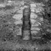
A magnetometer survey in the SW part of the fort showed substantial anomaly readings, particularly within Building XXII. An area 10 by 10m was excavated, revealing a cobbled surface at a depth of 0.3m with traces of a channel cut in it and several hollows associated with lead-working, later sealed with stones. Beneath the cobbles lay a wall, probably the west wall of Building XXII; inside the latter lay an accumulation of iron-working debris and a sequence of six superimposed smithing-hearths. The high magnetic reading was caused by a solid bank of slag at the edge of one of these. The fuel used was coal.
The remains suggest a fabrica rather than a barrack and sustained production at a high level of activity. (Work for Bradford University was directed by Mr M Gillings and Dr R J F Jones)
S S Frere 1988; E J MacKie 1971; P Ashbee 1989
Part of a small annexe was revealed by RCAHMS aerial survey, under unusually favourable soil- and crop-conditions, near the SW angle of the fort. Its relationship with the road running N to the S gate of the Domitianic fort suggests a Flavian date.
S S Frere 1991
Excavation in the SW of the fort revealed that in earlier Antonine occupations the 'Dividing Wall' had separated an extensive industrial area from more conventional fort buildings. Fort buildings constructed of rammed earth walls on stone foundations had at least two phases of modification. After demolition of the 'Dividing Wall' a sequence of sill-beam timber buildings was constructed over the industrial area. Following demolition of fort buildings a ditch was cut through the collapsed walls and the back of the rampart. Geophysical survey revealed plan detail of W sector of the fort and survey to the S indicated potential industrial structures aligned on 2 S roads from the fort. Also suggestions of masonry buildings S of the fort.
Possible 'traffic island' of Flavian date examined where westerly of 2 southern roads met to S Annexe ditch.
It is obvious now that the military complex at Newstead was considerably larger and more complex than previously thought.
Sponsors: National Museum of Scotland (NMS), University of Bradford, British Academy, Borders
Regional Council, Society of Antiquaries of London.
R F J Jones et al 1991.
Geophysical survey on sloping ground N of the fort suggested ditches running N to the River Tweed.
L J F Keppie 1994
NT 570 343 (centre) A jasper intaglio bearing an image of the emperor Caracalla was found near the N gate of the fort. Claimed as Treasure Trove (TT 114/99) and allocated to NMS (FRA 4771); it is displayed in the Trimontium Museum in Melrose, where it is on long-term loan.
A wide range of other finds have been recovered after ploughing, claimed as Treasure Trove (TT 116-17/99) and allocated to NMS, where full listings are held. Significant finds include brooch fragments, a button and loop fastener, and an architectural stone block bearing decorative mouldings (NMS FV 66) which is probably from the fort's S gate.
F Hunter 2000
NT 571 343 (centre) Extensive fieldwalking collections built up over 30 years were recently donated to NMS. The material includes a large number of intaglios (all previously published), unpublished copper-alloy finds (including knee and trumpet brooches, a dumb-bell strap mount, an enamelled belt fitting and a bell), a clay slingshot, a lamp fragment, and large quantities of pottery.
Additionally a base sherd of samian (now in NMS) was found casually at NT 572 348; it is from a Dr 33 C Gaulish cup and is stamped 'REGINM'.
F Hunter 2001.
Stone mould NT 571 345 Stone mould found casually just outwith the NE corner of Newstead fort (NT53SE 20). It is a small sandstone block, 45-53mm square, with moulds on two adjacent faces. One is for an ingot, the other for an unidentified D-shaped object with a central pendant bar; this was probably a blank which would subsequently be hammered to shape. The type is undiagnostic but the findspot suggests a Roman date.
Claimed as Treasure Trove (TT.53/04) and allocated to NMS.
F Hunter 2005
External Reference (3 August 2015)
The entry in the Schedule of Monuments relating to this monument was amended in 2015 (Ref SM12869).
Information from Historic Scotland, 3rd August 2015
Sbc Note (21 March 2016)
Visibility: This was the site of an archaeological monument, which may no longer be visible.
Information from Scottish Borders Council
Previously also listed under duplicate site NT96SW 510 -CANCELLED. HES (LCK) 11.6.2024
Magnetometry (5 October 2018 - 11 October 2018)
NT 56980 34410 and NT 4655 3847 Survey work was continued, 5–11 October 2018, to investigate relations between natives and Romans from a landscape perspective. In 2015 and 2017 the region around the sites Burnswark and Birrens were surveyed. In 2018 we started to open a comparative perspective in the region around Newstead, Eildon Hill and Torwoodlee.
The Roman occupation of Newstead has been the subject of several investigations. The new magnetometry confirms many of the observations drawn from the previous aerial imagery, but reveals considerably more detail. Apart from the confirmation of detailed structures in the interior of the fort, the magnetometry also presents several ‘batteries’ of ovens or furnaces in its surroundings. It clearly shows the precise layout of the vicus in the S annexe of the fort and several of the camp structures underneath the fort and to the E and SE. Moreover, it identified a circular structure, already recognised by Dave Cowley in 2012. Our magnetometry shows post settings inside the circular ditch and suggests an opening in the NW. A possible interpretation could be a horse gyrus, currently only recognised at forts at the Lunt, Baginton, Coventry, as well as Kempten (Cambodunum) and Mainz (Mogontiacum) (both Germany). Moreover, traces of linear anomalies, possibly indicative of a larger road (Dere Street?), might show in the E edge of the surveyed area.
At Torwoodlee a double ditch system for the N part of the hillfort was traced. Its interior is disturbed by traces of ridge and furrow as well as highly thermo-remanent anomalies that might also be of younger date. Their character should be traced by further examinations. The fields W of the hillfort show only a few traces of anthropogenic activities, except of some modern intrusions. The data of the survey on the slope E of the hillfort still needs some further data processing, but shows some circular structures that might be of anthropogenic origin. Some of the S slopes were also probed and showed only a few traces of anomalies. Most of them might be modern or of geological origin. Nevertheless, traces of agriculture and or horticulture are visible on the surface in the E area underneath the broch. Thus, the area to be investigated has not been exhausted. A total of 8.4ha were surveyed on the site. The gradiometer works were conducted with a GPSsupported 14-sensor fluxgate GM650B gradiometer device, with a 3m rig drawn by a quad bike. The surveys on the broch and inside the hillfort at Torwoodlee were carried out with a 5-sensor rig with the similar technical configuration that was carried by two persons.
The works were carried out in collaboration with the Trimontium Trust Melrose, the Archaeology Officer, Scottish Borders Council and Historic Environment Scotland.
Archive: Survey results to HES and Communal Archaeology
Scottish Borders
Funder: RGK, Trimontium Trust
Ruth Beusing, Nina Dworschak and John Reid – Römisch-
Germanische Kommission, Frankfurt (RGK) of the German
Archaeological Institut (Deutsches Archäologisches Institut)
(Source: DES, Volume 19)

