
Pricing Change
New pricing for orders of material from this site will come into place shortly. Charges for supply of digital images, digitisation on demand, prints and licensing will be altered.
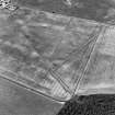
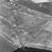
Penston


Field Boundary(S) (Period Unassigned), Road (Period Unassigned)
Site Name Penston
Classification Field Boundary(S) (Period Unassigned), Road (Period Unassigned)
Canmore ID 262941
Site Number NT47SW 155
NGR NT 44981 72170
Datum OSGB36 - NGR
Permalink http://canmore.org.uk/site/262941


- Council East Lothian
- Parish Gladsmuir
- Former Region Lothian
- Former District East Lothian
- Former County East Lothian
NT47SW 155 NT 44981 72170
A former road and ploughed down field boundaries, all of which are depicted on the 1st edition of the OS 6-inch map (Haddingtonshire 1848, Sheet 9), have been recorded as cropmarks on oblique aerial photography (RCAHMSAP 2000) lying on level ground immediately E of Penston.
Information from RCAHMS (KMM) 5 August 2004.

