
Pricing Change
New pricing for orders of material from this site will come into place shortly. Charges for supply of digital images, digitisation on demand, prints and licensing will be altered.
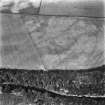
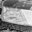
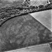
East Field, Inveresk


Pit Alignment (Prehistoric)
Site Name East Field, Inveresk
Classification Pit Alignment (Prehistoric)
Alternative Name(s) Eastfield; Old Craighall
Canmore ID 53855
Site Number NT37SW 23
NGR NT 34506 70211
NGR Description From NT 34430 70040 to NT 34470 70745
Datum OSGB36 - NGR
Permalink http://canmore.org.uk/site/53855


First 100 images shown. See the Collections panel (below) for a link to all digital images.
- Council East Lothian
- Parish Inveresk (East Lothian)
- Former Region Lothian
- Former District East Lothian
- Former County Midlothian
NT37SW 23 3 From NT 34430 70040 to NT 34470 70745
See also NT37SW 69-76, 178-9 and 187.
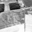
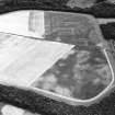
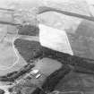
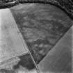
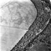
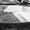
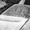
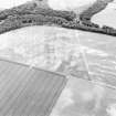
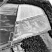
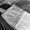
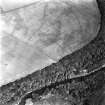
NT 344 700 to NT 344 707. A pit-alignment, first noted by the RCAHMS on National Survey aerial photographs (106G/Scot/UK119: 5119-20) meanders from N to S over East Field, Inveresk. Two of the pits, located by a resistivity survey, were excavated in 1957-8 by the Edinburgh University Archaeological Society but no datable evidence was recovered. (It was intended to carry out further work at this site, but no further reports appear to have been published.)
J Barber 1957; D D A Simpson 1958; G Maxwell 1970
Further aerial photographs have been taken by the RCAHMS who note a second pit-alignment at NT 344 703. (A number of other pit-alignments occur in the vicinity: see NT36NW 52, NT36NW 53, NT36NW 64 -68; NT37SW 64 and NT37SW 70. Cf pit-alignment at Meldon Bridge: NT24SW 46).
(Undated) information in NMRS.
There is nothing visible on the ground.
Visited by OS (BS) 15 August 1975
Aerial Photographic Transcription (1 April 2004 - 3 April 2004)
An aerial transcription was produced from oblique aerial photographs. Information from Historic Environment Scotland (BM) 31 March 2017.
Desk Based Assessment (22 September 2014 - 10 October 2014)
This project comprised a cultural heritage desk based assessment for the refurbishment of electrical overhead line between Smeaton, Dalkeith, Midlothian and Portobello, City of Edinburgh, Lothian. The refurbishment includes new wiring and insulators, new pylons and creation of associated access routes. The desk based assessment was carried out by Rubicon Heritage Services UK Ltd. during September and October 2014 on behalf of Hyder Consulting Ltd. The line of pylons traverses land of varying character; the southeast extent is farmland utilised for grazing while the northwest extent is located in the suburbs of the City of Edinburgh and the urban area of Portobello. The desk based assessment identified a number of cultural heritage assets in the study area. At the southeast extent the area has a complex of cultural heritage assets which range in date from prehistoric through to modern. Within this group are seven scheduled ancient monuments. The northwest extent of the line of pylons crosses an urban area in Portobello and the cultural heritage assets in this area comprise clay pits which were worked to provide resources for the local pottery industries in the post-medieval period and listed buildings which are part of the conservation area of Portobello. The proposed development will include some excavation which could impact any subsurface archaeological remains. Suitable mitigation measures were recommended after consultation with the local authority archaeologists. A number of scheduled ancient monuments are within the study area and consultation with Historic Scotland regarding scheduled monument consent is also necessary.
Information from Louise Baker (Rubicon Heritage Services UK Ltd) 23 October 2014. OASIS ID: rubiconh1-194501

