
Pricing Change
New pricing for orders of material from this site will come into place shortly. Charges for supply of digital images, digitisation on demand, prints and licensing will be altered.
Sweethope


Pit(S) (Prehistoric), Rig And Furrow (Medieval) - (Post Medieval), Ring Ditch (Prehistoric)
Site Name Sweethope
Classification Pit(S) (Prehistoric), Rig And Furrow (Medieval) - (Post Medieval), Ring Ditch (Prehistoric)
Alternative Name(s) Auburn Cottage
Canmore ID 53698
Site Number NT37SE 54
NGR NT 35875 71017
Datum OSGB36 - NGR
Permalink http://canmore.org.uk/site/53698


- Council East Lothian
- Parish Inveresk (East Lothian)
- Former Region Lothian
- Former District East Lothian
- Former County Midlothian
NT37SE 54 NT 35875 71017
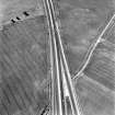
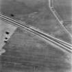
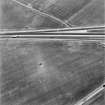
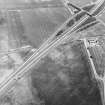
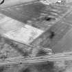
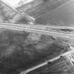
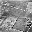
NT 358 711. Cropmarks (CUCAP).
(Undated) information in NMRS.
NT 358 710. Enclosure, Sweethope: visible on RCAHMS aerial photographs.
(Undated) information in NMRS.
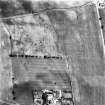
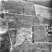
The cropmarks of a hut within an enclosure have been recorded by aerial survey (RCAHMSAP 1994). Situated approximately 200m NW of Auburn Cottage and S of the A1 trunk road, the cropmarks consist of a penannular ditch with an entrance way to the SE and centrally within the enclosure is a possible building. Traces of rig also occur in the same area.
Information from RCAHMS (JH) 7 September 1998.
This penannular ring-ditch has been recorded as cropmarks on oblique aerial photography (RCAHMSAP 1976, 1977, 1981, 1994, 1995, 2000). There are several pits in the interior.
Information from RCAHMS (DCC) 7 July 2004

