
Pricing Change
New pricing for orders of material from this site will come into place shortly. Charges for supply of digital images, digitisation on demand, prints and licensing will be altered.
Upcoming Maintenance
Please be advised that this website will undergo scheduled maintenance on the following dates:
Thursday, 9 January: 11:00 AM - 3:00 PM
Thursday, 23 January: 11:00 AM - 3:00 PM
Thursday, 30 January: 11:00 AM - 3:00 PM
During these times, some functionality such as image purchasing may be temporarily unavailable. We apologise for any inconvenience this may cause.
West Mains


Fort (Prehistoric)
Site Name West Mains
Classification Fort (Prehistoric)
Alternative Name(s) Falside
Canmore ID 53667
Site Number NT37SE 26
NGR NT 37537 70753
Datum OSGB36 - NGR
Permalink http://canmore.org.uk/site/53667


- Council East Lothian
- Parish Tranent
- Former Region Lothian
- Former District East Lothian
- Former County East Lothian
NT37SE 26 NT 37537 70753
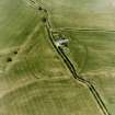
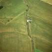
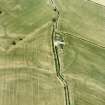
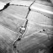
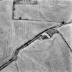
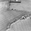
(NT 373 708) Crop mark (fort with triple ditches) seen from the air on 12 June 1939.
OS 6" map annotated by O G S Crawford.
(NT 375 708) A faint crop mark appears on aerial photographs, indicating double ramparts (RAF/CPE/Scot/UK276: 5438-9, flown 1947).
(Undated) information in NMRS.
NT 3758 7075. These crop marks fall in a flat arable field. No trace exists. No further information.
Visited by OS (SFS) 26 August 1975
Fort, West Mains: visible on RCAHMS and CUCAP (listed as a 'native settlement') aerial photographs.
(Undated) information in NMRS.
Note (1 December 2015 - 20 October 2016)
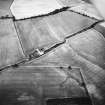
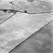
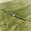
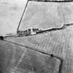
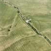
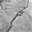
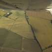
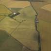
Cropmarks have revealed a complex fort beneath the ruins of West Mains steading, which lies at the SW end of Falside Hill, overlooking a gently shelving fold in the marked escarpment forming the NW flank of the hill. Roughly circular on plan, the defences comprise at least four ditches, but variations in their breadths and spacing suggest that they probably represent at least two and probably three phases of construction, to say nothing of the traces of palisade trenches that are also visible in some sectors. The innermost defences are made up of two concentric ditches from 3m to 4m in breadth and set 5m apart, and enclose an area measuring 105m from E to W by 110m transversely (0.9ha); a ragged internal mark about 4m within the inner ditch possibly marks the back of the rampart, its projected circuit indicating an interior of about 0.77ha. On some photographs traces of one line can be seen extending along the centre of this rampart, and a second between the two ditches, possibly indicating foundation trenches for palisades or timberwork in the ramparts. The outermost ditch is far more substantial than those of the inner defences and is likely to represent a separate phase of construction, though there is no visible stratigraphic sequence to indicate which might be the earlier. It measures between 4m and 7m in breadth, and is accompanied internally by a roughly concentric narrow ditch or palisade trench about 5m within its line, though on the NE, where there are traces of other linear features between them, the gap seems to open up to 13m. If elements of a single defensive scheme, they enclose an area measuring 170m from N to S by 150m transversely (2ha), but the equivalent measurements within the outermost ditch are 190m and 175m transversely (2.5ha), and if the rampart along its inner lip was some 5m thick the interior in this phase may have been as much as 2.3ha. One possible entrance through the inner defences lies on the NNE, apparently with slightly staggered gaps to create an oblique approach to expose the vistor's left side, but any others are lost in the diffuse cropmarks that obscure some sectors, or beneath the modern road. At least two can be detected in the outermost ditch, on the NNE and NNW respectively, and a third can be inferred from the dogleg carrying the line of the present road across the defences on the E. The gap on the NNW is no more than a causeway across the ditch, but on the NNE, in an area of diffuse cropmarks, the line of the outer seems to turn outwards, creating a slight stagger in the ditch terminals to either side of the gap, and the narrow internal ditch also detours outwards at the same point in the circuit; a linear marking approaching the entrance on the NNE is possibly a sunken trackway, though whether contemporary with one phase of the defences or simply traversing them at a later date is unclear. No internal features are visible on any of the 50 aerial photographs currently available.
Information from An Atlas of Hillforts of Great Britain and Ireland – 20 October 2016. Atlas of Hillforts SC3770

