
Forth Defences, Inchkeith, Anti Aircraft 3-inch Gun Emplacement


Guardhouse (20th Century), Gun Emplacement (Second World War)
Site Name Forth Defences, Inchkeith, Anti Aircraft 3-inch Gun Emplacement
Classification Guardhouse (20th Century), Gun Emplacement (Second World War)
Alternative Name(s) Forth Aa Defences
Canmore ID 271437
Site Number NT28SE 5.10
NGR NT 29503 82421
Datum OSGB36 - NGR
Permalink http://canmore.org.uk/site/271437


- Council Fife
- Parish Kinghorn
- Former Region Fife
- Former District Kirkcaldy
- Former County Fife
NT28SE 5.10 29503 82421
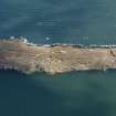
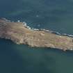
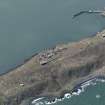
50m to the SE of NT28SE 5.06, is an emplacement for a 3" anti-aircraft gun. The position is visible on an oblique aerial photograph taken in 1941 (RAF S309, 6962, flown October 1941) .
Information from RCAHMS (DE), March 2005
NT28SE 5.10 29503 82421
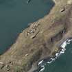
A brick and concrete anti aircraft emplacement is situated on the ridge immediately S of B Group gun emplacement (NT28SE 5.06).
The group, square shaped in plan, consists of a single square holdfast set on a concrete plinth and three brick and concrete ready use ammunition lockers to the S and crew shelter to the N.
The holdfast was for a 3-inch AA gun.
Visited by RCAHMS (DE, AL), 4th and 5th March 2009
Excavation (August 2007 - October 2007)
NT 2960 8230 (centred on) An archaeological survey and assessment were undertaken of an area proposed for a temporary anemometer mast and anchor point, at the southern end of Inchkeith Island during August–October 2007. The assessment identified 13 structures and four areas of archaeological interest in an area of approximately 5400m².
The subsequent excavation consisted of six ‘trenches’ for securing the base and anchor points of the mast. The trenches demonstrated the degraded nature of much of the volcanic bedrock in addition to illustrating that certain areas retain deep soil profiles. Finds from the excavations were late 19th and 20th-century in date. Archaeological features included cables and services, relating to the First or Second World War occupation. All archaeological features were left in situ.
Archive and Report: RCAHMS (intended)
Funder: SLP Energy Ltd
Dan Atkinson and George Geddes (Headland Archaeology Ltd), 2008
Archaeological Evaluation (August 2007)
Sea & Land Power and Energy Ltd. commissioned Headland Archaeology Ltd to undertake an archaeological survey and assessment of an area for a proposed temporary anemometer mast and anchor points at the south end of Inchkeith Island in the Firth of Forth. As Inchkeith is a Scheduled Ancient Monument (SAM 3838), Scheduled Monument Consent is required for the installation of the anemometer from Historic Scotland, acting
on behalf of the Scottish Ministers. The assessment identified thirteen structures and four areas of archaeological interest that lie within the assessment area, which formed an area approximately 90m by 60m or 5400m². The survey succeeded in plotting these structures and features within a general topographic survey in relation to the proposed location of the mast plate and 5 anchor points. These locations were assessed as to the level of potential impacts that their introduction may have on archaeological features. This has resulted in a minor modification of
the proposed location in order to minimize any impacts.

