
Following the launch of trove.scot in February 2025 we are now planning the retiral of some of our webservices. Canmore will be switched off on 24th June 2025. Information about the closure can be found on the HES website: Retiral of HES web services | Historic Environment Scotland
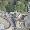
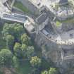
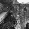
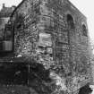
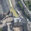
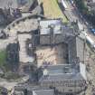
Edinburgh Castle, Inner Barrier


Gateway (17th Century)
Site Name Edinburgh Castle, Inner Barrier
Classification Gateway (17th Century)
Canmore ID 52076
Site Number NT27SE 1.16
NGR NT 25210 73497
Datum OSGB36 - NGR
Permalink http://canmore.org.uk/site/52076


- Council Edinburgh, City Of
- Parish Edinburgh (Edinburgh, City Of)
- Former Region Lothian
- Former District City Of Edinburgh
- Former County Midlothian
NT27SE 1.16 2521 7349.
Inner Barrier (NR).
OS 1/500 plan, (1895).
Centred at 2149
(Not published on 1/1250 (1947))
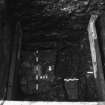
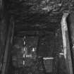
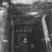
Inner Barrier, known as the "2d gate" in the 17th century, when it was protected by a draw-bridge.. (RCAHMS 1951).
Visited by OS(JLD) 23 October 1953.
(Centred at NT 2521 7349) No additional remarks.
Visited by OS(JLD) 29 December 1953.
Described as 'Inner Battery' on wall plaque.
Visited by OS(VEL) 2 February 1954.
As described in previous field report
Visited by OS(SFS) 10 November 1975.
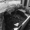
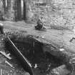
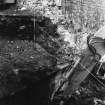
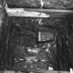
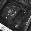
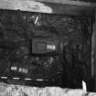
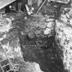
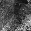
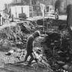
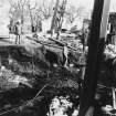
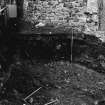
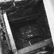
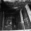
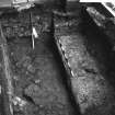
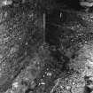
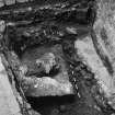
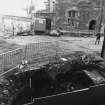
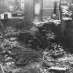
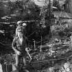
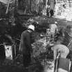
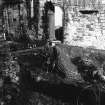
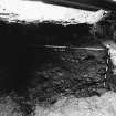
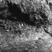
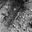
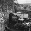
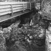
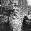
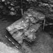
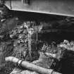
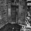
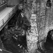
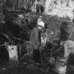
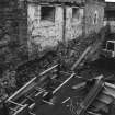
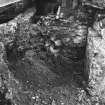
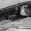
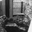
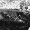
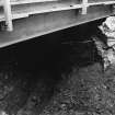
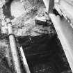
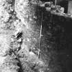
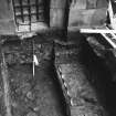
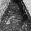
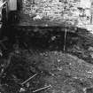
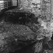
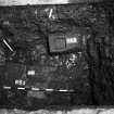
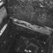
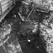
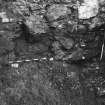
Area L. Outside the Inner Barrier. A narrow area adjacent to the old ticket office was excavated in advance of the E cut and cover section of the tunnel. Two metres of 19th and 20th century infilling was removed to reveal the NW corner of the old Port Guard, dated c1800. This building was resting on bedrock and no earlier deposits were encountered.
Sponsor : SDD (HBM)
P Yeoman 1988
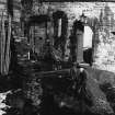
Area L Inner Barrier, Forecourt, Eastern Cut-and-Cover Tunnel
Further remains of the Port Guard (c1700) were found to the S of the complex phases of 17th and 18th century inner defences. A ditch, as such, never existed at the Inner Barrier, but rather a set of three massive masonry built pits formed the barrier. These are accurately depicted in a drawing of the Castle by Captain John Slezer dating to c1695, at the point where the post-medieval raised road passes first over a timber bridge, then a central lifting bridge and finally over another flat removable, timber bridge before passing through the Inner Barrier portal.
Sponsor : SDD (HBM)
P Yeoman 1989
Publication Account (1951)
THE APPROACH.
The approach to the Castle itself is by way of the Esplanade, across the head of which runs the Dry Ditch constructed some time between 1725 and 1742. The ditch is now traversed by a modern drawbridge, some scanty remains of an earlier bridge being seen on the left-hand side. The way of access then passes through an arched pend in the modern gatehouse, in the walls of which are inserted two interesting 17th-century panels sculptured with trophies of arms. On one of these the cannon known as Mons Meg can be identified. Inside and facing the back of the gate-house rises the Half-Moon Battery, constructed in 1574 and commanding the whole of the Old Town, which lies from one hundred to three hundred feet below. About 20 ft. below the parapet can be seen a gunloop, masked until recently by the wall of the battery; this was formed in the old curtain on the N. side of David's Tower at some time in the early 16th century, and is consequently the oldest gunloop in the Castle. The report of 1572 mentions six cannons int his part of the defences.
The access next skirts the N. base of the Battery up to the Inner Barrier, known as the “2d gate” in the 17th century, when it was protected by a drawbridge, and then runs up to the former position of the “Constable's Tower”, which is to-day occupied by the Portcullis Gate, or Morton's Gateway. The lower part of this latter building dates from 1574, and contains a vaulted transe adapted for two outer doors in two leaves, a portcullis, and an inner door, also in two leaves. The outer archway has an architectural framework of the period with superimposed double pilasters at each side. On a string course above, two seated lions rest as finials and flank an heraldic achievement. The heraldic panel, which exhibits the Royal Arms of Scotland below a crown, is modern, but the base and entablature are original. The frieze is enriched with hearts and mullets, charges which pertain to the Douglas coats of arms. The archway at the inner end of the transe is plain. A heavily barred window above lights a vaulted portcullis-room resting on the transe. On emerging from the gatehouse the road runs between the Argyle Battery on the right, where there was an inner gate, and the " long stairs" on the left, the latter a short cut to the summit of the Rock, partly rebuilt in 1785. It then winds round a shoulder and, entering through Foog's Gate (Fig.73), which dates from the 17th century, reaches the inner enclosure known as The Citadel, which it should be remembered had been the only fortified portion of the site down to the middle of the 16th century.
RCAHMS 1951
Excavation (23 February 2009 - 4 April 2009)
NT 252 734 (centred on)
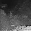
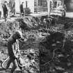
A service trench was excavated 23 February–3 April 2009 in advance of the construction of a new ticket checking booth. The trench ran from the re-entrant angle between the Portcullis Gate and the curtain wall (fromthe existing manhole adjacent to the Audio Guide Kiosk, to the Server Room located on the N side of the Entrance Gateway). The trench measured c80m x 0.55m by 0.3m deep and cut across parts of the complex sequence of the eastern defences. However, the excavations only revealed levelling deposits beneath the present road, backfill and 19th- and 20th-century services.
G Ewart and A Radley 2009
Sponsor: Historic Scotland
Kirkdale Archaeology

