
Scheduled Maintenance
Please be advised that this website will undergo scheduled maintenance on the following dates: •
Tuesday 3rd December 11:00-15:00
During these times, some services may be temporarily unavailable. We apologise for any inconvenience this may cause.
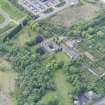
Edinburgh, West Granton Road, Caroline Park Avenue, Caroline Park House


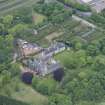
Country House (17th Century)
Site Name Edinburgh, West Granton Road, Caroline Park Avenue, Caroline Park House
Classification Country House (17th Century)
Alternative Name(s) Flemings; Caroline Park Policies
Canmore ID 52056
Site Number NT27NW 3
NGR NT 22670 77187
Datum OSGB36 - NGR
Permalink http://canmore.org.uk/site/52056


- Council Edinburgh, City Of
- Parish Edinburgh (Edinburgh, City Of)
- Former Region Lothian
- Former District City Of Edinburgh
- Former County Midlothian
NT27NW 3.00 22670 77187
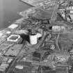
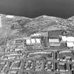
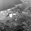
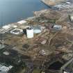
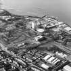
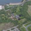
NT 227 771 (centre) Following on from a desk-based assessment and field inspection, the Environmental Impact Assessment for cultural heritage within the Central Development Area, Granton, recommended a programme of archaeological works in advance of development. The former designed landscape and gardens associated with the 17th-century A-Listed building, Caroline Park House (NT27NW 3), lies partially within the Central Development Area.
The first phase of work comprised an archaeological evaluation along the route of the transport spine for the development and parts of the Upper Strand of Caroline Park.
The evaluation demonstrated that preservation of archaeological features is variable across the development area. Since the 1830s increasing industrialisation of Caroline Park has taken place. Much of the development area comprises made ground associated with industrial activity, which has removed all trace of either garden, designed landscape or earlier features. However, there are pockets of survival within the development area where features associated with the former designed landscape are preserved. A programme of excavation was undertaken to examine these areas further.
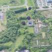
Excavation at three areas of archaeological sensitivity uncovered features which corresponded with features recorded on maps of the estate, thus clarifying the layout of the designed landscape and providing details on construction methods and stratigraphic relationships.
At the eastern end of the avenue approaching Caroline Park House from the E, a small stub of upstanding wall survived, while the evaluation produced a curved length of wall. The excavations revealed a semi-circular revetment wall approximately 19m in external diameter. Two returns were present on the N and S sides of the semi-circle, the S measuring 2m long and the N measuring 4.5m long. Each had been truncated by past ground removal works to allow construction of the railway line and an industrial premises. The wall had a slight batter to it and was leaning towards the interior of the semi-circle, and only the external wall face was faced. Remnants of a white mortar/plaster finish on the exterior wall face was not present on the inner side. A metric survey was undertaken of the elevation of this wall. It seems likely that the semi-circular wall functioned as a ha-ha, with the internal deposits considerably higher than the external ground surface. The eastern avenue may have functioned as a grassy vista culminating in a ha-ha to provide unencumbered views out to the Firth of Forth and North Berwick Law. The structure is shown as two conjoined semi-circles on a map of 1768, its earliest known depiction.
Two gravel-surfaced roads were discovered, the first measuring 22 x 4m, comprising the remains of the main carriageway approaching the house from the S, as illustrated on 18th-century historical maps of the estate. The second comprised a road measuring 15.0 x 2.8m running through the estate, lying immediately to the S of the former formal walled gardens adjacent to the house. Its position suggests that it may be the W end of the eastern avenue or it may be a road subsidiary and to the S of this avenue, as indicated on Edgar's map of 1740. A path or track is indicated in this position on the 1855 OS map.
Data Structure Reports deposited in the NMRS.
Sponsor: Waterfront Edinburgh Ltd.
M Johnson (CFA) 2002.
(NT 22670 77187) Caroline Park (NR)
OS 1:10,000 map, (1975)
NT27NW 3.01 NT 22740 77351 Gates
NT27NW 3.02 NT 22632 77288 Walled Garden
NT27NW 3.03 NT 22654 77220 Offices (North West Range; Royston House)
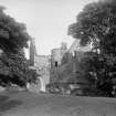
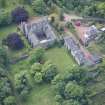
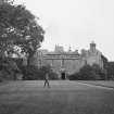
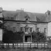
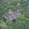
Caroline Park House was built in 1685 by Sir George Mackenzie, later Viscount Tarbet. It is quadrangular in form, and the present south front was added in 1696. It still contains well-preserved contemporary panelling and decorative paintings.
RCAHMS 1929, visited 1921; Anon 1952.
This mansion is still known as 'Caroline Park House'. It is in a good state of preservation, and is as described and planned.
Visited by OS (V E L) 4 March 1954.
No change to previous field report.
Visited by OS (B S) 26 November 1975.
Royston House [NAT]
Caroline Park [NR]
OS 1:10,000 map, 1987.
Architect: William Burn 1835 - plans for repairs
William Adam 1741 - new kitchen garden wall
Caroline Park House was known as Royston House previous to 1740 when the Duke of Argyll, proprietor of the Barony of Royston purchased the adjacent Barony of Granton. Granton House, also known as Old Granton House, Granton Castle & Royston Castle then became known as Royston House - RMB
First floor, west room of main 1696 block, closet has beams which were inserted from an earlier building found after the fire. The rest of the beams are in Abbey Strand, Canongate, Edinburgh.
Gates on Lodge at Gogar removed from SeaGate Caroline Park
See NMRS Walks in Edinburgh Margaret Warrender p155
The paintings were commissioned by John the Second Duke of Argyll and Greenwich, and the barony and name of Caroline Park House was also created by him, long after George Mackenzie Viscount Tarbat.
Information supplied by current owner, August 2008
REFERENCES
National Archives of Scotland
RHP 9714/34-35 19th c - plan & elevation of lodge
18th c - estate plan
RIBA Drawings Collection - plan with gardens
Dec 12th 1781 Edinburgh Evening Courant advertised to let 'Late Sir James Adolphus Oughton'
Feb 2nd 1782 Edinburgh Evening Courant Sale of Goods advertised Mrs Milton at Caroline Park
Beds & Bedding, window curtains, tables, drawers, sofa, 3 Handsome mahogany book cases with glass doors A large Quantity of furniture
National Library Saltoun Papers Box (?) 36 - Letter 10th Nov. 1741 from Wm Smith at Caroline Park to Fletcher on the building of the new kitchen garden wall staked out by Mr Adam.
Dr Thomas Ross - manuscript notes
Country Life, June 28th, ?1928 - year uncertain
(Undated) information in NMRS.
Field Visit (9 February 1921)
Caroline Park.
The barony of Royston marched with the barony of Granton, and the respective mansions were adjacent. The residence of the Royston estate was Royston House, and that of Granton, Granton House, but in 1740 when John, second Duke of Argyll and Greenwich, the then proprietor of Royston, purchased the Granton property he combined the two estates under the name of ‘Caroline’ Park after his eldest child, who married the Earl of Dalkeith. Royston House then became Caroline Park House, and Granton House was known as Royston House.
Caroline Park House (Fig. 53) has been continuously occupied since its erection in 1685 by Sir George Mackenzie, who was in that year created Viscount Tarbat and later Earl of Cromarty. For the last half-century it has been the offices of a firm of chemists. It is the only structure so far noted in these Inventories in which the contemporary panelling, modelled plaster work, and decorative paintings are at all complete and well-preserved. The house stands 500 yards south-west of the western wharf of Granton Harbour, on an old raised beach just above the 50-feet contour line and within a small park, all that remains of the extensive pleasure grounds and 100-acre park mentioned by Lord Cockburn (1), whose father tenanted the property from 1796-7 for a period of thirty-five years.
Viscount Tarbat, on acquiring the estate, laid out his new house in the form of a quadrangle enclosing a paved court, as the fashion of the time was. In an inscription on the building he modestly designates the structure a cottage, though it is quite a commodious mansion.
The entrances were two in number, and were centrally situated in the north and south wings. The northern was the principal, the main approach being from the north-east, where the fine entrance gate-piers still remain in situ. They are contemporary with the present south front of the house, which was embellished by Tarbat in 1696, and probably superseded the plainer entrance gate adjacent. The iron gates are said to have been removed to Gogar House (NT17SE 9) and thence to Sauchieburn in Stirling.
The house is a low-set harled structure of two storeys in all wings but that on the south, where upper chambers are contrived within the roofs. The north front is simple but distinctive. The lateral wings have coupled roofs received on skewed gables of eccentric form. The central portion has a fiat roof surmounted by a good balustraded parapet with well-moulded stone balusters square on plan and diagonally disposed like those on the look-out of Woolmet House (NT36NW 36). Midway in its length the balustrade is interrupted by a panel bordered with carving rather reminiscent of the churchyard and inscribed: ‘GAZÆ CONGESTÆ NIHILI/IMPENSÆ USUI SUNT / CUM GLEBIS / AUGENTUR ET LABORES / IN NOSTRUM ERGO / ET AMICORUM SOLATIUM / TUGURIOLUM HOC / EDIFICARE CURA-RUNT/ GEORGIUS ET ANNA / VICECOMITES A TARBAT / ANNO ÆRÆ CHRIST 1685 / INTRA TUM HOSPES / NAM HOSPITIUM EST / NUNC NOSTRUM / TUNC ALTERIUS / POSTEA VERO / NEC SCIO NEG CURO CUIUS / NAM NULLI CERTA DOMUS / Viven-dum ergo dum licet esse bene’: ‘Riches heaped up are worth nothing, laid out they are of service. To add field to field is to increase labour. Therefore, for our own comfort and that of friends, George and Anna, Earl and Countess of Tarbat, had this cottage built in the year of Christ 1685. Enter then, guest, for the lodging is now ours, by and by it will be another's, but whose afterwards I neither know nor care, for to no one is a house sure. Let us enjoy life, therefore, while it lasts.’
[For a detailed architectural description, see RCAHMS 1929 pp. 32-36].
RCAHMS 1929, visited 9 February 1921.
(1) Journal of Henry Cockburn, ii, p.143.
Photographic Survey (January 1966)
Photographic survey by the Scottish National Buildings Record/Ministry of Work in January 1966.

