
Pricing Change
New pricing for orders of material from this site will come into place shortly. Charges for supply of digital images, digitisation on demand, prints and licensing will be altered.
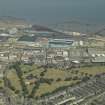
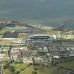
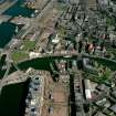
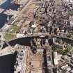
Edinburgh, Leith Docks, Edinburgh Dock


Dock (19th Century)
Site Name Edinburgh, Leith Docks, Edinburgh Dock
Classification Dock (19th Century)
Alternative Name(s) Firth Of Forth; Outer Forth Estuary
Canmore ID 51980
Site Number NT27NE 57.05
NGR NT 27659 76700
Datum OSGB36 - NGR
Permalink http://canmore.org.uk/site/51980


- Council Edinburgh, City Of
- Parish Edinburgh (Edinburgh, City Of)
- Former Region Lothian
- Former District City Of Edinburgh
- Former County Midlothian
NT27NE 57.05 27659 76700
See also:
NT27NE 57.11 NT 27559 76765 Swing Bridge between Albert and Edinburgh Docks
NT27NE 57.13 NT 27780 76767 Hydraulic Power Station
NT27NE 57.17 NT 27768 76627 Dry Dock
NT27NE 57.21 NT 27550 76710 Warehouse
NT27NE 57.22 NT 27840 76440 Transit Shed
Edinburgh Dock [NAT] (at NT 2769 7668)
OS 1:1250 map, 1969.
The current edition of the OS (GIS) AIB depicts the S part of the dock as having been infilled.
Information from RCAHMS (RJCM), 13 June 2006.

