
Pricing Change
New pricing for orders of material from this site will come into place shortly. Charges for supply of digital images, digitisation on demand, prints and licensing will be altered.
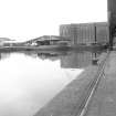
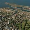
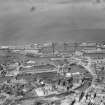
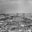
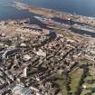
Edinburgh, Leith Docks, Imperial Dock


Dock (Period Unassigned)
Site Name Edinburgh, Leith Docks, Imperial Dock
Classification Dock (Period Unassigned)
Alternative Name(s) Firth Of Forth; Outer Forth Estuary
Canmore ID 51979
Site Number NT27NE 57.04
NGR NT 27200 77200
Datum OSGB36 - NGR
Permalink http://canmore.org.uk/site/51979


- Council Edinburgh, City Of
- Parish Edinburgh (Edinburgh, City Of)
- Former Region Lothian
- Former District City Of Edinburgh
- Former County Midlothian
NT27NE 57.04 27200 77200
Location formerly cited as NT 272 771.
See also:
NT27NE 57.23 NT 27585 76902 Grain Elevator
NT27NE 57.49 NT 26987 77430 Imperial Dry Dock
NT27NE 57.54 NT 26970 77350 Old Entrance Lock
NT27NE 57.57 NT 27262 77017 Swing bridge between Imperial Dock and Albert Dock
Imperial Dock [NAT] (at NT 2720 7720)
OS 1:1250 map, 1972.

