
Pricing Change
New pricing for orders of material from this site will come into place shortly. Charges for supply of digital images, digitisation on demand, prints and licensing will be altered.
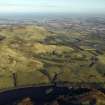
Castle Law


Farmhouse (Period Unassigned), Farmstead (Period Unassigned), Sheepfold (Period Unassigned), Wind Generator (20th Century)
Site Name Castle Law
Classification Farmhouse (Period Unassigned), Farmstead (Period Unassigned), Sheepfold (Period Unassigned), Wind Generator (20th Century)
Canmore ID 110880
Site Number NT26SW 66
NGR NT 2298 6370
Datum OSGB36 - NGR
Permalink http://canmore.org.uk/site/110880


- Council Midlothian
- Parish Glencorse
- Former Region Lothian
- Former District Midlothian
- Former County Midlothian
NT26SW 66 2298 6370
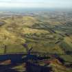
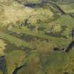
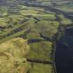
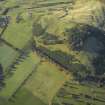
Castlelaw, which is still a working sheep farm, comprises a farmhouse, a much altered 19th century steading and more recent buildings. The farmhouse and part of the steading are currently used to accommodate students of the Scottish Agricultural College and were not accessible on the date of visit.
The farmhouse, which faces roughly E over the remains of a square garden, was probably built in the early 1800s and enlarged towards the end of the century. The house consists of three bays and one and a half storeys, and is built of harled rubble under a slate roof. The north gable shows evidence of alteration, and what appears to be a fireplace jamb is exposed. This may have been installed in preparation of a proposed extension or else reused when the house was enlarged.
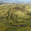
The range stands behind the farmhouse and is L-shaped on plan, its open side facing onto the rear of the farmhouse. Most of the SW wing of the range is occupied by a three-bay cart-shed, its bays separated by cast iron columns, but at its NW end, turning the corner into the NW wing, there is a byre. Next to this is a two-storey stable with evidence of a cobbled floor and a drain, and a hayloft above is now accessed by an internal stair. The 1st edition of the OS 6-inch map (Edinburghshire 1854, sheet 12) depicts a circular horse-engine (annotated 'Threshing Machine') against the NW side of this part of the range, indicating its use as a barn at that time. Nothing is visible of this today and it is not shown on the 2nd edition of the map (1905, sheet VII.SW), suggesting that the role of the building had probably changed by the beginning of the 20th century. The greater part of the NW wing has been converted into single-storey housing with a flat-roofed extension to the rear, but retains the original rubble walls and Scotch slate roof. There is a detached two-bay rubble-built sheep shelter at the NE end of the range.
In addition to these early- to late-19th century buildings just described, the steading now includes a large modern shed immediately SW of the old range. Formerly, a sheepfold stood on a low rise about 20m S of this shed. According to the present shepherd at the farm, this fold was constructed of steel-sheeting. Circular on plan, two concentric walls were roofed over to form a shelter and the centre was open. This fold was not in existence in 1960, when the area was recorded on an RAF vertical aerial photograph (F41 158/RAF/3544, print 0180), but it had been built by 1969, when it was recorded on an Ordnance Survey vertical aerial photograph (69/235/393). All that is now visible of the fold is a low, stony platform, which measures about 12m in diameter by 0.3m in height and is best-preserved on the NW. Nothing is now visible of the wind generator that formerly stood immediately S of the fold.
(CDTA05 72)
Visited by RCAHMS (JRS, STG) September 2005

