
Pricing Change
New pricing for orders of material from this site will come into place shortly. Charges for supply of digital images, digitisation on demand, prints and licensing will be altered.
Glencorse, Castlelaw Range


Beacon (20th Century), Building (20th Century), Firing Range(S) (20th Century), Hut (20th Century), Trench (20th Century)
Site Name Glencorse, Castlelaw Range
Classification Beacon (20th Century), Building (20th Century), Firing Range(S) (20th Century), Hut (20th Century), Trench (20th Century)
Alternative Name(s) Castlelaw Hill; Castle Law
Canmore ID 110879
Site Number NT26SW 65
NGR NT 22591 64014
NGR Description Centred NT 22591 64014
Datum OSGB36 - NGR
Permalink http://canmore.org.uk/site/110879


- Council Midlothian
- Parish Glencorse
- Former Region Lothian
- Former District Midlothian
- Former County Midlothian
NT26SW 65 centred 22591 64014
For associated Glencorse Barracks (NT 2473 6195), see NT26SW 64.00.
Castlelaw Range [NAT] (at NT 224 640)
Butts [NAT] (at NT 2248 6411)
Dismantled Tramway [NAT] (at NT 2245 6401)
Firing Point [NAT] (at NT 2248 6395)
Firing Point [NAT] (at NT 2251 6382)
Firing Point [NAT] (at NT 2258 6373)
OS 1:10,000 map, 1983.
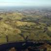
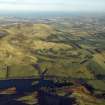
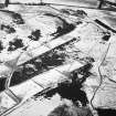
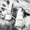
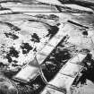
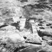
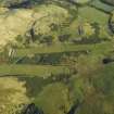
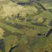
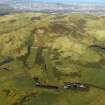
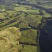
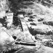
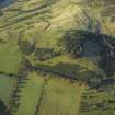
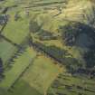
The military firing ranges at Castlelaw, which are situated on a broad terrace and extend into a natural hollow at the foot of the S flank of Castlelaw Hill, comprise two small-arms firing ranges, two roofed buildings, a sentry hut and the demarcated danger area. The ranges have undergone several changes in the past 60 years, and were completely remodelled in the early 1980s. The earlier configuration of the range is revealed on an RAF vertical aerial photograph taken in 1947 (CPE/Scot/UK281, 5322). At that time it comprised a single rifle range, with firing points at 100 yard intervals up to a distance of 600 yards. A tramway carried moving targets past the rear of the 100 yard firing point, and there were also four buildings and two nissen huts (CDTA05 253-58) standing to the E of the range, and three more buildings (CDTA05 62, 69, 259) at the S end.
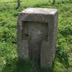
The remodelling of the range in the early 1980s destroyed the N part of the old range but several features of the S end are still visible. These comprise one of the buildings (CDTA05 62), now reduced to its concrete floor, the embanked firing positions at the 400, 500, and 600 yard distances, and several installations associated with servicing the firing positions, such as stone range-markers (CDTA05 226 & 229) and concrete electricity (CDTA05 227, 230-32) and telecommunication posts (CDTA05 223 & 228). A practice-trench immediately S of the range is now largely filled in, but its zig-zag course can still be followed along the crest of the steep edge of the terrace bounding this end of the range.
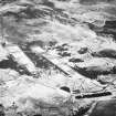
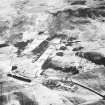
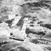
The reconstructed range, which was completed in 1985, saw the construction of two new ranges, A and B. Range B, the western, was built over the N end of the earlier range. The target tramway was removed, and the buildings were demolished, to be replaced by two new structures (CDTA05 115 & 210). Range A, the eastern, measures 600 yards in length and Range B 400 yards. Each comprises grass-grown embanked firing points from which troops can fire either in prone positions or in standing positions in firing holes. The butts are at the N end of the ranges, and the targets are mounted on hand-controlled frames raised from a sunken concrete corridor. There are also automated 'pop-up' targets, which are housed on the roofs of both butts, behind which is a sand embankment rising to a height twice that of target frames. At the W end of each butt there is a roofed concrete store. The targets of both ranges are numbered from 1 to 12, and a wooden number in front of each target corresponds with the number of the firing position.
A brick-built building (CDTA05 115) standing immediately E of Range A contains an observation post on the NNW and a power plant on the SSE. The flat concrete roof of the observation post overhangs the NNW end and the entrance is in the WSW side. There are also windows in the NNW end and in the WSW side, both of which are protected by metal shutters. The SSE end of the building, which contains a diesel generator, is open to the sky and has double doors in its ENE side. This end of the building is clad externally with wood, installed to prevent ricochets from stray bullets. The second of the new buildings (CDTA05 210), which is situated immediately W of the SSE end of Range A, contains the offices of the Range Warden, stores and toilets.
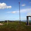
A concrete sentry hut (CDTA05 106) is situated on the summit of Castlelaw Hill, adjacent to a flagpole and summit cairn (NT26SW 132). There are six flag poles (CDTA05 50, 107, 109, 262-4) demarcating the limit of the danger area, each with a red warning beacon lights on its top. The flags are flown or the beacons lit when the ranges are in use.
CDTA05 62, 50, 106-7, 109, 115, 210, 226-9, 230-2, 262-4
Visited by RCAHMS (AGCH) 8 June 2005

