
Pricing Change
New pricing for orders of material from this site will come into place shortly. Charges for supply of digital images, digitisation on demand, prints and licensing will be altered.
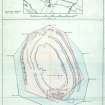
Castlelaw


Boundary Marker (20th Century)
Site Name Castlelaw
Classification Boundary Marker (20th Century)
Canmore ID 277324
Site Number NT26SW 2.05
NGR NT 22833 63887
NGR Description NT 22833 63887
Datum OSGB36 - NGR
Permalink http://canmore.org.uk/site/277324


- Council Midlothian
- Parish Glencorse
- Former Region Lothian
- Former District Midlothian
- Former County Midlothian
NT26SW 2.05 22833 63887
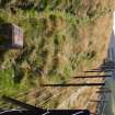
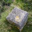
This boundary marker, which stands adjacent to a post-and-wire fence on the WNW side of Castlelaw fort, is a concrete pillar measuring 0.23m square in section and rising 0.32m in height to a flat top with a narrow bevelled edge. The top bears an incised arrow pointing towards the centre of the fort.
(CDTA05 95)
Visited by RCAHMS (JRS) 8 June 2005.

