
Pricing Change
New pricing for orders of material from this site will come into place shortly. Charges for supply of digital images, digitisation on demand, prints and licensing will be altered.
Castle Law


Rig And Furrow (Medieval) - (Post Medieval)
Site Name Castle Law
Classification Rig And Furrow (Medieval) - (Post Medieval)
Canmore ID 270011
Site Number NT26SW 119
NGR NT 2289 6396
Datum OSGB36 - NGR
Permalink http://canmore.org.uk/site/270011


- Council Midlothian
- Parish Glencorse
- Former Region Lothian
- Former District Midlothian
- Former County Midlothian
NT26SW 119 2289 6396
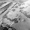
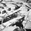
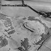
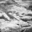
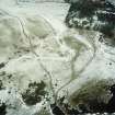
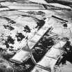
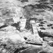
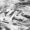
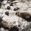
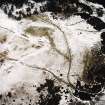
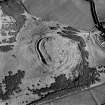
An area of ploughed down rig has been recorded on oblique aerial photography (RCAHMSAP 2000) surrounding Castle Law fort and settlement and extending to the N.
Information from RCAHMS (KMM) 15 December 2004.
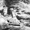
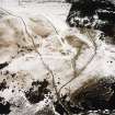
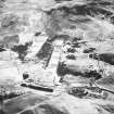
There are extensive traces of rig-and-furrow cultivation on the SE flank of Castlelaw Hill, running from the E side of the military firing ranges (NT26SW 65), over the ridge occupied by the Castlelaw fort (NT26SW 2) and the palisaded enclosure on Castle Knowe (NT26SW 21), and onto the steep, SE-facing slopes overlooking the modern improved fields. The rigs immediately E of the N end of the range (formerly NT26SW 118) display a variety of alignments and represent at least two phases of cultivation. The earlier rigs are broad and sinuous, separated by wide furrows. These are overlain by rigs with a flatter profile and are separated by comparatively narrow furrows, in some places closely-spaced. These rigs occupy the whole of the slope forming the E side of the ranges, but appear to peter out immediately SW of the Castlelaw fort. Here the slope is steep and has been disturbed by quarrying, but the rig is visible on the slope immediately S of the fort and it extends NE in a series of fragmentary plots across the slope forming the SE flank of Castle Knowe and continues almost as far as the slope above the Fraser-Tytler Memorial (NT26SW 39).
On the NW side of the Castlelaw fort the rigs override the outer ditch and the counterscarp bank, and one rig appears to have been cultivated the length of the N side between the innermost rampart and the internal quarry ditch of the outer defences. On the S side, rigs measuring about 5m in breadth run uphill onto the lip of the counterscarp bank, but above this the defences have been transformed into a series of cultivation terraces at right-angles to the axis of the rig. The interior has also been extensively cultivated, with a series of low parallel scarps (on three separate alignments) being recorded during a plane-table survey by RCAHMS in 2005.
Visited by RCAHMS (JRS) 7 June 2005

