
Pricing Change
New pricing for orders of material from this site will come into place shortly. Charges for supply of digital images, digitisation on demand, prints and licensing will be altered.
Brunston Castle, Garden


Garden (16th Century)
Site Name Brunston Castle, Garden
Classification Garden (16th Century)
Alternative Name(s) Brunstane; Brunstain; Brunstone
Canmore ID 120712
Site Number NT25NW 4.02
NGR NT 201 582
NGR Description Centred NT 201 582
Datum OSGB36 - NGR
Permalink http://canmore.org.uk/site/120712

- Council Midlothian
- Parish Penicuik (Midlothian)
- Former Region Lothian
- Former District Midlothian
- Former County Midlothian
NT25NW 4.02 centred 201 582
Field Visit (2 December 2019 - 24 February 2020)
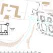
(NT 2023 5850) Desk-Based Assessment - The Garden area (HER: MEL4983) associated with Brunston Castle (SM: 1192, Canmore: 51646, HER: MEL8054) surrounds the structure on all sides. There is an area of the garden covered under the HER that will be affected by the proposed forestry plan. To the E of the ruin of Brunston Castle (SM: 1192, Canmore: 51646, HER: MEL8054) is an area associated with fish ponds. These are now dried up and comprise four flat mounds separated and enclosed by flat bottomed ditches 7.0m broad and up to 1.0m high. The mounds range in size from 12.0m by 8.0m to 19.0m by 11.0m (Visited by OS (BS) 6 November 1975).
Walkover survey - There is an area of the garden covered under the HER that will be affected by the proposed forestry plan. This area is flat and located to the E of Brunston Castle. The fish pond is sited to the N but outwith the planting area.
Information from OASIS Id: rathmell1-387946 (P Klemen and T Rees) 2020

