
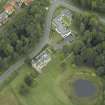
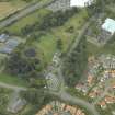
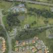
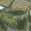
Dunfermline, Castle Drive, Pitreavie Castle, Garden And Sundial


Garden (18th Century), Glasshouse (19th Century) - (20th Century), Sundial (17th Century)
Site Name Dunfermline, Castle Drive, Pitreavie Castle, Garden And Sundial
Classification Garden (18th Century), Glasshouse (19th Century) - (20th Century), Sundial (17th Century)
Canmore ID 83719
Site Number NT18SW 9.02
NGR NT 11750 84846
Datum OSGB36 - NGR
Permalink http://canmore.org.uk/site/83719


- Council Fife
- Parish Dunfermline
- Former Region Fife
- Former District Dunfermline
- Former County Fife
This 17th century sundial is no longer at Pitreavie Castle, it having been removed from there to Inveresk Lodge Garden in 1968 (see NT37SW 162.3). (Information from HES, Survey and Recording (JRS) 28 February 2020.
NT18SW 9.02 11783 84818
NT 1188 8485 mid- to late 19th-century greenhouse complex: greenhouse, boiler house, cold frames, walling of walled garden.
Report lodged with Fife SMR and the NMRS.
Sponsor: George Leslie Ltd.
S Farrell 1997
NT 1187 8476 - NT 1187 8485 Rectangular walled garden, 1890s.
NT 1180 8476 - NT 1187 8476 Japanese water garden, 1890s.
Full details are contained in a report lodged with the NMRS.
Sponsor: Ironside Farrar Environmental Consultants at the request of Fife Enterprise.
T Neighbour 1997
Field Visit (7 August 1928)
SUNDIAL. Behind the house stands a sundial of "lectern" type on an octagonal step (Fig. 48 [SC 1108703]). The square pedestal, like that of the dial at Aberdour House (NT18NE 7.01), is borne on four stone spheres and has a cartouche on each side. The northern face shows a lozenge-shaped escutcheon bearing a fess checky between three mascles, for Wardlaw. The southern one bears: A fess and in base a mascle, for Beaton of Balfour.* The eastern one bears the initials S.H.W., while the western one has a heart-shaped centre with the date 1644. The dial proper rises from a moulded capital. The total height, measured from the step, is 6 feet 3 inches. The date and initials indicate that the sundial was erected by the second Sir Henry Wardlaw (1637-53), whose wife was Margaret Beaton of Balfour.
RCAHMS 1933, visited 7 August 1928.
*This should properly be a fess between three mastles.

