
Pricing Change
New pricing for orders of material from this site will come into place shortly. Charges for supply of digital images, digitisation on demand, prints and licensing will be altered.
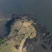
Charles Hill Battery


Gun Emplacement (20th Century)
Site Name Charles Hill Battery
Classification Gun Emplacement (20th Century)
Alternative Name(s) Forth Defences
Canmore ID 271289
Site Number NT18SE 27.01
NGR NT 18635 83809
Datum OSGB36 - NGR
Permalink http://canmore.org.uk/site/271289


- Council Fife
- Parish Dalgety
- Former Region Fife
- Former District Dunfermline
- Former County Fife
NT18SE 27.01 18642 83805
A twin 6-pounder gun emplacement is situated on the E-facing slope of Charles Hill overlooking Mortimer's Deep.
The emplacement has been constructed using shuttered concrete and has collapsed in part of the frontal section.
Information from RCAHMS (DE), March 2005; J Guy 1994; NMRS MS 810/3, 88
Measured Survey (27 August 2022 - 28 August 2022)
HES surveyed the gun emplacement at Charles Hill Battery between 27-28 Aug 2022 with plane table and alidade producing two survey drawings at a scale of 1:100. The first drawing comprised a plan and section of the lower level of the gun emplacement (including gun pit, magazine, duty watch room and gun store) and the second drawing comprised the upper level (including store rooms, control tower and a further structure). The resultant plans were redrawn in vector graphics software at a scale of 1:200.
Field Visit (25 July 2022)
The fixed gun emplacement at Charles Hill was constructed on the crest and steep rocky face at the E end of the promontory with extensive views across the River Forth. It comprised seven elements. On the lower eastern part of the emplacement, overlooking the river, there is a gun-pit that was flanked by a crew shelter immediately to the S and a gun store immediately to the N; a magazine was situated directly SW of the gun-pit. On the higher western part of the emplacement there was a store above and adjacent to it was a control tower. The present survey has identified a hitherto unrecognised structure which once sat between the store and the gun store. These features are described clockwise starting with the pit in which the gun was located.
Gun-pit. First fitted with a single 6-pound gun and later a twin 6-pounder, the gun-pit is centred on a holdfast comprising a steel ring 2.13m (7ft) in external diameter set into the top of a concrete foundation that slopes away to the rear and sides of the pit. Ten 72mm (3in) high tensile steel bolts on a diameter of 1.98m (6ft 6in) secured the gun. The holdfast is fronted on the E by a low concrete wall 1.05m in thickness and 0.65m in height. Elsewhere the pit is enclosed within a raised walkway set into the surface of which are the twin steel rails (0.6m (2ft) along which two ammunition trollies (one for each gun) were intended to run. Three sets of concrete steps provided access to the walkway from rear of the emplacement and below the walkway were five ammunition lockers accessed from the rear of the emplacement. These lockers all measure 1.44m in width by 0.76m in depth and 0.99m in height and are now missing their steel double blast doors. The five lockers are set symmetrical to the emplacement but the three sets of steps that provide access to the raised walkway are not. The likely reason for this was the necessity for each ammunition locker to be adjacent to at least one set of steps. Two sets of steps wouldn’t work and four would be one too many.
In addition to the low but thick concrete wall that fronted the pit there were two ‘wing walls’ set on top of it, leaving a gap of 5.8m in front of the guns. These wing walls measured 0.7m high, that on the N angling back to meet the SE corner of a gun store and that on the S angling back to join the NE corner of crew shelter. Later, when the emplacement was provided with a concrete half-canopy roof, the N wing wall was raised to support it. However, on the S side the roof support was set back from the wing wall and built on the walkway, over the ammunition trolley rails. The reason for this is likely to have been that the twin 6-pounder required a wider field of fire than its predecessor. As originally built, the wall immediately to the rear of the emplacement ran from the NE corner of the magazine (see below), where it stood 2.16m high, towards the N where it ran (gradually reducing in height) past the rear of the gun store. When the half-canopy was added, this wall was raised to a height of about 3.8m.
The Crew Shelter to the S of the gun-pit is a single rectangular room measuring 4.57m from N to S by 3.05m transversely beneath a ceiling 2.43m high. There is a doorway and a window on the W side and the brick-built base for a stove mid-way along the E wall, with a hole in the ceiling above for a chimney. Still fixed to the N wall is a rack of coat hooks. A circular aperture in the centre of the roof probably housed a vent.
The Gun Store on the N side of the gun-pit is also a single chamber, measuring 3.05m square below a ceiling 2.43m high. There is a doorway and window on the W side and although there is no evidence of a stove base against the E wall there is a hole for a possible chimney in the ceiling.
The Magazine lies to the SW and slightly below the level of the gun-pit and most of the space it occupies has probably been excavated out of solid bedrock. Internally, it measures 7.3m from N to S by 3.95m below a flat roof 2.7m in height. Ammunition was supplied to the gun-pit via a hatch opening in the E wall that measures 1.07m in width but only 0.92m high. The entrance (1.07m wide) to the magazine was in the centre of the W wall and it was approached from the outside via a long flight of steps which led up towards the control tower and the store.
Control Tower. The control tower, which stood to the W of and at a higher level than the gun-pit and comprised a two-level structure containing on its lower level a Searchlight Directing Station and a [Gunfire] Director Tower above, has been almost entirely removed. The floor of the lower level survives, measuring 2.5m from E to W by 2.45m within the stumps of its walls. There was a doorway on the W and also still visible is the footing (0.5m square) for an instrument pedestal and, in the SE corner, the top of a ceramic pipe that probably once acted as a conduit for electricity and telephone cables. All that now remains to indicate the presence of the upper level of the tower are the concrete footings of the stair that once led up to it.
Store. The store stands in the NW corner of the emplacement and comprises a flat-roofed rectangular building containing two rooms, both measuring 2.45m square within walls 0.38m thick and a ceiling 2.11m high. Both rooms have an entrance on the W, approached from the outside by a broad set of steps, and in the roof of both there is a central aperture measuring some 300mm in diameter which probably housed a vent. The southerly room has a narrow horizontal vent high up on its S side, running through to the floor of the control tower.
Structure. Situated between the store and the passage that runs past the W side of the gun store is the site of a building. It measures some 6m from N to S by 5m transversely over a concrete raft that is supported on a brick revetment wall on the E and N where there is a short flight of steps. At the outer edge of the concrete floor and directly above the supporting brick walls is a shallow rebate that either indicates the former presence of a (single thickness) brick-built superstructure or a timber building. The purpose of the building is not known but it may have provided the administrative space not available elsewhere within the emplacement.
Visited by HES Archaeological Survey (J. Sherriff; A. McCaig) 25 July 2022.

