
Pricing Change
New pricing for orders of material from this site will come into place shortly. Charges for supply of digital images, digitisation on demand, prints and licensing will be altered.
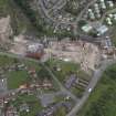
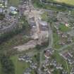
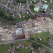
Kirkliston, The Square, Kirkliston Parish Church, Churchyard Extension


Burial Ground (Period Unassigned), Cemetery (Period Unassigned), Churchyard (Period Unassigned)
Site Name Kirkliston, The Square, Kirkliston Parish Church, Churchyard Extension
Classification Burial Ground (Period Unassigned), Cemetery (Period Unassigned), Churchyard (Period Unassigned)
Alternative Name(s) Kirkliston Cemetery
Canmore ID 274975
Site Number NT17SW 19.04
NGR NT 12418 74349
Datum OSGB36 - NGR
Permalink http://canmore.org.uk/site/274975


- Council Edinburgh, City Of
- Parish Kirkliston (City Of Edinburgh/w Lothian)
- Former Region Lothian
- Former District City Of Edinburgh
- Former County West Lothian
NT17SW 19.04 12418 74349
For churchyard see NT17SW 19.02
For watch house see NT17SW 19.03
For modern cemetery see NT17SW 245
INVENTORY OF GRAVEYARD AND CEMETERY SITES IN SCOTLAND REFERENCE:
N.B. This reference applies collectively to NT17SW 19.00, NT17SW 19.02, NT17SW 19.03, NT17SW 245
Address: Kirkliston Parish Church and Burial Aisle, Churchyard, Churchyard extension/Cemetery and Cemetery, The Square, Kirkliston
Postcode: EH19 9AX
Status: In current use for burials
Size: Churchyard: 0.20 hectares, 0.49 acres; Churchyard extension/Cemetery: 0.44 hectares, 1.08 acres; Cemetery: 0.26 hectares, 0.64 acres
Polygon: No
TOIDs:
Number of gravestones: Not Known
Earliest gravestone: Not Known
Most recent gravestone: Not Known
Description: Church with burial aisle, burial ground associated with a church, modern cemetery.
Data Sources: OS MasterMap checked 12 September 2005; Bereavement Services Portal checked 12 September 2005

