
Pricing Change
New pricing for orders of material from this site will come into place shortly. Charges for supply of digital images, digitisation on demand, prints and licensing will be altered.
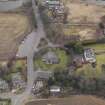
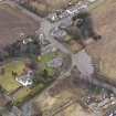
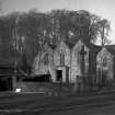
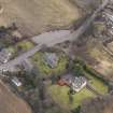
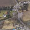
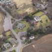
Edinburgh, Ratho Burial Ground


Burial Ground (Post Medieval), Churchyard (Post Medieval)
Site Name Edinburgh, Ratho Burial Ground
Classification Burial Ground (Post Medieval), Churchyard (Post Medieval)
Alternative Name(s) Ratho Village; Churchyard
Canmore ID 144343
Site Number NT17SW 14.01
NGR NT 13845 71012
NGR Description Centred NT 13845 71012
Datum OSGB36 - NGR
Permalink http://canmore.org.uk/site/144343


- Council Edinburgh, City Of
- Parish Ratho
- Former Region Lothian
- Former District City Of Edinburgh
- Former County Midlothian
NT17SW 14.01 13845 71012
INVENTORY OF GRAVEYARD AND CEMETERY SITES IN SCOTLAND REFERENCE:
N.B. This reference applies collectively to NT17SW 14.00 and NT17SW 14.01
Address: Ratho Parish Church and Burial ground, Baird Road, Ratho
Postcode: EH28 8RU
Status: No known
Size: Burial ground: 0.23 hectares, 0.58 acres
Polygon: No
TOIDs:
Number of gravestones: Not Known
Earliest gravestone: Not Known
Most recent gravestone: Not Known
Description: Church with former burial aisles, grave slab and burial ground associated with church.
Data Sources: OS MasterMap checked 13 September 2005

