
Whiteside Plantation


Rig And Furrow (Medieval)
Site Name Whiteside Plantation
Classification Rig And Furrow (Medieval)
Alternative Name(s) Clubbiedean Burn
Canmore ID 293225
Site Number NT16NE 205
NGR NT 19861 66190
NGR Description Centred NT 19861 66190
Datum OSGB36 - NGR
Permalink http://canmore.org.uk/site/293225


- Council Edinburgh, City Of
- Parish Edinburgh (Edinburgh, City Of)
- Former Region Lothian
- Former District City Of Edinburgh
- Former County Midlothian
NT16NE 205 centred 19861 66190
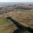
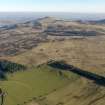
An area of rig and furrow cultivation has been identified from oblique aerial photographs (RCAHMS 2008) on the N and S of Whitesdie Plantation. That to the S is still well defined but only extends as far as a field boundary about 127m away. The area to the N is visible in a well cultivated arable field and in a field of rough grazing immediately to the SW.
The area of rig extends as far as the Malleny Rifle Range and Cock Rig (NT16NE 56).
Information from RCAHMS (DE), March 2008

