
Pricing Change
New pricing for orders of material from this site will come into place shortly. Charges for supply of digital images, digitisation on demand, prints and licensing will be altered.
Castlethorn


Standing Stone(S) (Prehistoric)(Possible)
Site Name Castlethorn
Classification Standing Stone(S) (Prehistoric)(Possible)
Alternative Name(s) Canniewell Slack; Torphichen Hills; Torphichen Mains
Canmore ID 47943
Site Number NS97SE 38
NGR NS 9745 7251
Datum OSGB36 - NGR
Permalink http://canmore.org.uk/site/47943


- Council West Lothian
- Parish Torphichen
- Former Region Lothian
- Former District West Lothian
- Former County West Lothian
NS97SE 38 9745 7251
See also NS97SE 53.
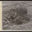
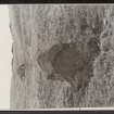
NS 9745 7251. Possible Standing Stone/Stone Circle (rems), Canniewell Slack: This site lies W of and below the summit of Canniewell Slack, a saddle between Gormyre Hill and Castlethorn, and about 550 m E of Torphichen Preceptory (about 700ft OD).
One stone ('A') stands earthfast, the packing stones around its base being clearly visible, possibly being eroded by sheep. It is triangular in section, 0.58m high, 0.58m wide at base and 0.43m broad; it appears pointed.
Another stone ('B'), also triangular, lies 8.2m ESE of 'A'; it may originally have stood like 'A', but at present it lies on its side, one of its triangular faces being uppermost. It is 0.76m long, 0.79m wide, and 0.48 m broad; its height is 0.46m.
The ground at this point forms a level platform, which is consistent with the hypothesis of the existence of a stone circle 8m in diameter, and on a brief study of the ground surface together with some probing, it is suggested that there may be other stones beneath the rough turf. Information from A McLean letter, 25 September 1979.
These two stones mark the trackway leading from the fort NS97SE 53, and appear to be associated with it.
Visited by RCAHMS (JBS) 20 August 1985 .
Scheduled (with NS97SE 53) as Castlethorn, fort and standing stones.
Information from Historic Scotland, scheduling document dated 22 February 2005.

