
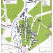
Wilsontown


Bell Pit(S) (18th Century) - (19th Century)
Site Name Wilsontown
Classification Bell Pit(S) (18th Century) - (19th Century)
Alternative Name(s) Wilsontown Ironworks
Canmore ID 99535
Site Number NS95SE 11.12
NGR NS 9523 5511
NGR Description Centred NS 9523 5511
Datum OSGB36 - NGR
Permalink http://canmore.org.uk/site/99535


- Council South Lanarkshire
- Parish Carnwath
- Former Region Strathclyde
- Former District Clydesdale
- Former County Lanarkshire
NS95SE 11.12 centred 952 551
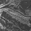
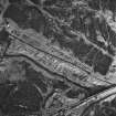
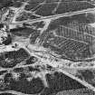
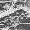
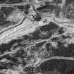
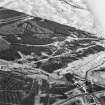
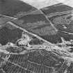
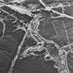
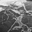
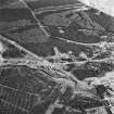
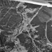
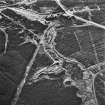
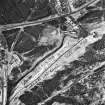
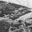
To the E of the Wilsontown Ironworks (NS95SE 11.01), on former moorland now afforested, there are about seventy bell pits in an area measuring about 600m N-S by 200m E-W, each comprising a ring of grassed-over spoil around the head of a shaft. In some cases trackways can be traced running from one pit to another; these are generally fragmentary, but at least one track leads towards the remains of the ironworks. These pits are not depicted on an 1826 map of the Wilsontown estate (National Library of Scotland, Map Library, ref. no. EMS.P.166), nor are they shown on the 1st edition of the OS 25-inch map (Lanarkshire 1864, sheet xx.2), and it seems likely that they date from the early years of the ironworks, from 1779 onwards.
Visited by RCAHMS (SDB) October 1994.

