
Stirling


Battle Site (13th Century)
Site Name Stirling
Classification Battle Site (13th Century)
Alternative Name(s) Stirling Bridge
Canmore ID 47241
Site Number NS89SW 1
NGR NS 800 946
Datum OSGB36 - NGR
Permalink http://canmore.org.uk/site/47241


- Council Stirling
- Parish Stirling
- Former Region Central
- Former District Stirling
- Former County Stirlingshire
NS89SW 1 800 946.
In 1297 Sir William Wallace in the lowlands and Andrew of Moray in the north rebelled against the English rule recently imposed by Edward I; and the king's lieutenant John de Warrenne, Earl of Surrey, and Hugh de Cressingham, treasurer for Scotland, led an army against them while the king was in Flanders. Their march north was blocked at Stirling by the united forces of Wallace and Andrew of Moray established on the north bank of the Forth.
The Battle of Stirling Bridge (sometimes called the Battle of Cambuskenneth) was fought on 11th September 1297 and resulted in the complete defeat of the English. Their vanguard (at the least) was allowed to pass over the narrow bridge, which was then closed by a body of Scots spearmen and the whole English force on the north side of the river was destroyed in marshy and restricted terrain where cavalry could not be properly employed.
The contemporary account of Walter de Hemingborough (H C Hamilton 1849) states that, before the battle, the Scots were stationed on what must have been the Abbey Craig ('in altera parte montis supra Monasterium de Skambskynel'(Cambuskenneth)) and that they had a strong tactical position ('nec fuit aptior locus in regne Scotiae ad concludendum Anglices in manus Scotorum et multos in manus paucerum'). It also mentions that Sir Richard Lundy, a Scots knight with the English, knew of a ford nearby ('vadum non longe abhinc') over which he offered to lead a force to take the Scots in the rear.
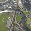
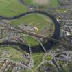
The exact locality of the bridge, and therefore of the actual battle-ground, has been a matter of some conjecture. It has been widely supposed (Nimmo (1880); NSA (1845) and others) that it was at Kildean (NS 783 950) and it is this supposition, according to Ramsay (1908), which is responsible for the Ordnance Survey 6" map (1942-8) siting at NS 795 959. But the best modern authority for the siting is W B Cook (1906) whose arguments in favour of the bridge being actually in Stirling and of the fighting taking place in the horse-shoe bend centred at NS 800 946 are very convincing and are endorsed by Sir James Ramsay who, in turn, is quoted as the authority for the battle by Sir Maurice Powicke. Briefly they are as follows:-
a. There was a bridge in Stirling in 1297. This is proved by an early 14th century charter authorising its repair and showing that it was approximately in the present position by reference to place-names still extant. The remains of this bridge have been found just north of the 'Old Bridge'.
b. As there was a bridge in Stirling it would be extravagant to suppose that there was also one at Kildean, especially as no references to such are known and no remains have been identified.
c. Bridges usually replace ferries, not fords, and there was a ford at Kildean of which Cook had first-hand knowledge.
d. The ford at Kildean could reasonably be that over which Sir Richard Lundy offered to lead an outflanking force. It it is not, then there is no known ford which could be described as 'non longe abhinc'.
e. The north bank of the river at Kildean would allow cavalry to deploy almost immediately after crossing whereas opposite Stirling Bridge it is marshy and narrowing. Only at the latter position could infantry have successfully attacked cavalry, and therefore it is only there that the tactical situation described by Hemingborough exists.
The Battle can therefore be sited with some certainty to the area NS 800 946.
Information from OS Recorder (GL) 12 August 1958.
The Battle of Stirling Bridge, 1297. The area has been developed and is now Causewayhead Playing fields. There is no further information.
Site recorded by GUARD during the Coastal Assessment Survey for Historic Scotland, 'The Firth of Forth from Dunbar to the Coast of Fife' 23 February 1996.
This battlefield was included in a nation-wide study of key battle sites. A detailed gazetteer was created by The Battlefield Trust, which includes an historical overview of each site, detailed assessments of the action and its location and the number of troops involved, casualties, sources of information and an interpretation of the events and its impact on history. For more detail see the gazetteer and associated materials - MS 2522.
The impressive 19th-century Wallace Monument stands on Abbey Craig, in the general area from which Wallace is believed to have surveyed the battlefield prior to the action. Most of the area of the battle is built up or developed, but a small area on either side of the old bridge remains are still undeveloped.
G Foard, T Partida 2005
Excavation (27 February 2012 - 2 July 2012)
NS 79818 94579 A programme of archaeological work was undertaken on 27 February and 29 June – 2 July 2012 at two locations within the site of the Battle of Stirling Bridge, 1297 (Bridgehaugh and Stirling County Rugby Pitch). A series of hand dug test-pits were excavated by local volunteers under the supervision of Stirling Council Archaeology Service in association with GUARD Archaeology Ltd and Glasgow University’s Centre for Battlefield Archaeology. A metal detector survey of the area was also undertaken by the Scottish Artefact Recovery Group. The work identified medieval, post-medieval and Victorian finds. The most significant find was the discovery of medieval pottery putatively identified as dating to the 13/14th century.
Archive: Stirling SMR
Funder: Stirling Council, GUARD Archaeology Ltd, Centre for Battlefield Archaeology and SARG
Murray Cook, Stirling Council, 2012
(Source: DES)

