
Pricing Change
New pricing for orders of material from this site will come into place shortly. Charges for supply of digital images, digitisation on demand, prints and licensing will be altered.
Alloa, Forthbank, Caudron Aerodrome And Aircraft Factory


Airfield (First World War), Factory (First World War)
Site Name Alloa, Forthbank, Caudron Aerodrome And Aircraft Factory
Classification Airfield (First World War), Factory (First World War)
Alternative Name(s) Bowhouse Farm
Canmore ID 303288
Site Number NS89SE 238
NGR NS 88737 91639
NGR Description Centred NS 88737 91639
Datum OSGB36 - NGR
Permalink http://canmore.org.uk/site/303288


- Council Clackmannan
- Parish Alloa
- Former Region Central
- Former District Clackmannan
- Former County Clackmannanshire
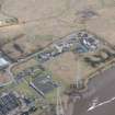
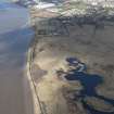
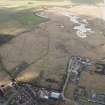
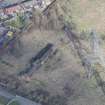
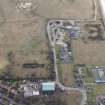
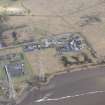
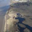
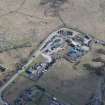
Alloa aerodrome was the aerodrome of the British Caudron Company, attached to its aircraft factory, which was sited in buildings at the NW end of the site. The factory was established in 1915 and produced fifty BE2 type and 100 Sopwith Camels, under licence. The factory closed after the war but the aerodrome was used by an aerial photography and advertising company after 1922. The aerodrome was marked on a map of 1924, where it is shown as extending to 11.8 hectares, bounded on the south-west side by the River Forth. By 1925 the site had been acquired by a ship-building company. Fife (2007) suggests that the site was subsequently built over by housing, but no subsequent maps shows this. The 4th edition of the OS 6-inch map depicts a mine and railway yards on the airfield site. No trace survives of the aerodrome or the factory buildings.
Information from HS/RCAHMS World War One Audit Project (GJB) 11 June 2013.
NS89SE 238 centred 88737 91639
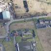
Nothing is visible in disturbed ground situated on the N bank of the River Forth SE of Alloa within an area now occupied by a sewage works and refuse destructor of a First World War aircraft factory and airfield .
The factory opened in 1916 to produce aircraft of several types. The factory employed mainly women during the First War and constructed no more aeroplanes after 1919, with the Company going out of business in 1924.
The airfield was in a field immediately to the E of the factory (Information via e-mail from Ms Susan Mills to Lorna Main of Striling Council, 12 April 2010).
The factory is depicted on the Revision edition of the OS 25-inch map (Stirlingshire, c.1922) which shows a large building of two compartments with two smaller roofed buildings to the N. It is annotated the 'Caudron Aeroplane Factory'. The area occupied by the factory lies to the W of the refuse destructor depicted on the currant OS digital maps.
Information from RCAHMS (DE); Ms S Mills via e-mail to L Main, Sitrling Council Environmental Services.
Project (March 2013 - September 2013)
A project to characterise the quantity and quality of the Scottish resource of known surviving remains of the First World War. Carried out in partnership between Historic Scotland and RCAHMS.

