
Scheduled Maintenance
Please be advised that this website will undergo scheduled maintenance on the following dates: •
Tuesday 3rd December 11:00-15:00
During these times, some services may be temporarily unavailable. We apologise for any inconvenience this may cause.
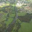
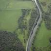
Antonine Wall, Military Way


Frontier Defence (Roman), Roman Road (Roman)
Site Name Antonine Wall, Military Way
Classification Frontier Defence (Roman), Roman Road (Roman)
Canmore ID 227074
Site Number NS87NW 32.02
NGR NS 8160 7935
NGR Description NS 8000 7875 to NS 8500 7984
Datum OSGB36 - NGR
Permalink http://canmore.org.uk/site/227074


- Council Falkirk
- Parish Falkirk
- Former Region Central
- Former District Falkirk
- Former County Stirlingshire
NS87NW 32.02 8000 7875 to 8500 7984
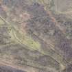
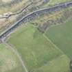
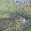
NS 837 798 A pipe-line cut the Military Way W of the cattle-grid giving access to the Guardianship Area. The partial section showed a lower cobbled stratum of Roman road under the modern road; the former rested on a double layer of turf, the lower of these laid grass downwards.
L J F Keppie 1975; R Goodburn 1976.
NS 8000 7875 to NS 8066 7900 East of Woodend the Ditch and Military Way 'appear in great perfection' 2 chains apart, and continue so to the Nether-town of Seabeg (Horsley 1732).
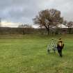
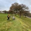
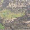
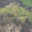
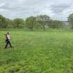
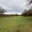
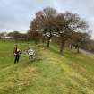
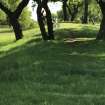
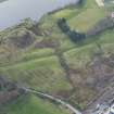
NS 8119 7920 to NS 8161 7935 Military Way is extant, and shows generally as a level track with loose stone although its original agger [causeway], c.5m wide and 0.3m high, is discernable in places. Old sections (indicated) show compact cobbling. Under Scottish Development Department (Inspectorate of Ancient Monuments) Guardianship.
NS 8132 7925 Military Way sectioned in c.1890 (Glasgow Archaeological Society 1899).
NS 8151 7932 Military Way sectioned in c.1890 (Glasgow Archaeological Society 1899).
NS 8159 7935 Military Way sectioned in 1962 (Hunter 1962).
NS c.8182 7951 Military Way passed through garden on S side of Seabegs Place (Horlsey 1732).
NS 8185 7950 The field to the S of Seabegs Place was trenched with the aid of a machine in advance of housing development. No features were located except at the N margin of the field. Here, hand dug trenches uncovered stone foundation material which may represent the S edge of the Military Way which would then have underlain the present track known as Seabegs Place. It is possible that the foundations related to the Medieval settlements here (Bailey 1989).
NS c.8189 7957 Short length of Military Way shown on Macdonald's OS 2 and a half inch record map. No account given, and no mention made of Roman Wall in Scotland.
NS 8220 7969 Military Way alleged to have been located at this point in 1972 (Price and Price 1972). The evidence of NS 8220 7969 is insufficient to project a course for the Military Way.
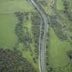
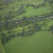
NS 8300 7972 to NS 8400 7984 No original features of the Military Way survive; it underlies a track and is then utilized as a path around Elf Hill. It was not races further west.
NS 8374 7979 Military Way sectioned beneath line of modern track c. 1975 (Keppie 1975-6).
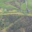
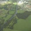
NS 8400 7980 to NS 8425 7985 Crossing the Rowantree Burn by the only viable route, the Military Way is located again on level ground as a grassed agger [causeway] running obliquely to the line of the Wall. Published course resurveyed.
NS 8440 7981 Formerly published detail of by-pass and loop roads of Military Way now deleted. Excavated evidence for their exact positions and functions is tenuous (see NS87NW 6) and there is no surface trace.
NS 8450 7991 to NS 8468 7996 Military Way emerges from tip running parallel to Wall; scrub covered agger [causeway] as per NS 8500 7984 to NS 8482 7992. Fresh tipping in this area may encroach. The line fades as it enters the E side of the fort annexe.
NS 8482 7992 to NS 8500 7984 Stony agger [causeway] of Military Way, c. 5.5m wide and 0.3m high, crosses scrub and wasteland running parallel to Wall. Lost beneath tip at NS 8482 7992. Published course correct.
Information from OS 1980
Bailey 1989; K Docherty and E J Price 1972; Glasgow Archaeological Society 1899; J Horlsey 1732; D M Hunter 1962; L J F Keppie 1975-6
NS 818 794 In June 1989, a two-week long archaeological assessment was undertaken in a field S of Seabegs Place, Bonnybridge in advance of house development. The field lay some 70m S of the Antonine Wall and it was thought possible that the Military Way ran across it. An area of random stonework composed of cobbles was uncovered, however it was impossible to determine whether this was medieval or Roman in date.
L J G Keppie, G B Bailey, A J Dunwell, J H McBrien, K Speller 1995.
Antiquarian Observation (1732)
NS 8000 7875 to NS 8066 7900 East of Woodend the Ditch and Military Way 'appear in great perfection' 2 chains apart, and continue so to the Nether-town of Seabeg (Horsley 1732).
Antiquarian Observation (1732)
NS c.8182 7951 Military Way passed through garden on S side of Seabegs Place (Horlsey 1732).
Excavation (1890)
NS 8151 7932 Military Way sectioned in c.1890 (Glasgow Archaeological Society 1899).
Excavation (1890)
NS 8132 7925 Military Way sectioned in c.1890 (Glasgow Archaeological Society 1899).
Antiquarian Mapping (1934)
NS c.8189 7957 Short length of Military Way shown on Macdonald's OS 2 and a half inch record map. No account given, and no mention made of Roman Wall in Scotland.
Field Visit (1972)
NS 8220 7969 Military Way located at this point in 1972 (Price and Price 1972).
Excavation (1975)
NS 8374 7979 Military Way sectioned beneath line of modern track c. 1975 (Keppie 1975-6).
Watching Brief (1975)
NS 837 798 A pipe-line cut the Military Way W of the cattle-grid giving access to the Guardianship Area. The partial section showed a lower cobbled stratum of Roman road under the modern road; the former rested on a double layer of turf, the lower of these laid grass downwards.
L J F Keppie 1975; R Goodburn 1976.
Field Visit (1980)
NS 8482 7992 to NS 8500 7984 Stony agger [causeway] of Military Way, c. 5.5m wide and 0.3m high, crosses scrub and wasteland running parallel to Wall. Lost beneath tip at NS 8482 7992. Published course correct.
Information from OS 1980
Field Visit (1980)
NS 8220 7969 Military Way alleged to have been located at this point in 1972 (Price and Price 1972). The evidence of NS 8220 7969 is insufficient to project a course for the Military Way.
Field Visit (1980)
NS 8119 7920 to NS 8161 7935 Military Way is extant, and shows generally as a level track with loose stone although its original agger [causeway], c.5m wide and 0.3m high, is discernable in places. Old sections (indicated) show compact cobbling.
Information from OS 1980
Field Visit (1980)
NS 8300 7972 to NS 8400 7984 No original features of the Military Way survive; it underlies a track and is then utilized as a path around Elf Hill. It was not races further west.
Field Visit (1980)
NS 8400 7980 to NS 8425 7985 Crossing the Rowantree Burn by the only viable route, the Military Way is located again on level ground as a grassed agger [causeway] running obliquely to the line of the Wall. Published course resurveyed.
Information from OS 1980
Field Visit (1980)
NS 8440 7981 Formerly published detail of by-pass and loop roads of Military Way now deleted. Excavated evidence for their exact positions and functions is tenuous (see NS87NW 6) and there is no surface trace.
Information from OS 1980
Field Visit (1980)
NS 8450 7991 to NS 8468 7996 Military Way emerges from tip running parallel to Wall; scrub covered agger [causeway] as per NS 8500 7984 to NS 8482 7992. Fresh tipping in this area may encroach. The line fades as it enters the E side of the fort annexe.
Information from OS 1980
Publication Account (1985)
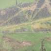
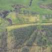
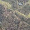
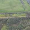
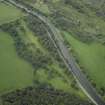
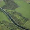
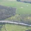
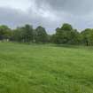
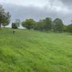
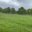
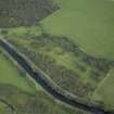
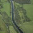
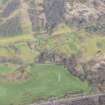
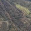
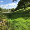
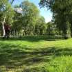
Preserved in the vestiges of Sea begs Wood there is a good stretch of the Wall which includes the bestsurviving section of the Military Way. The Wall was built just above a marked break in slope giving it the maximum military advantage and offering a clear view over the valley of the Bonny Water. The ditch is about 12m broad but for much of its length it is waterlogged and choked with vegetation. To the north, the upcast mound is clearly visible, and on the south the narrow berm between the inner lip of the ditch and the base of the Wall appears as a distinct terrace. The Wall itselfis comparatively well-preserved and still stands to a maximum height of 1.2m. The most interesting feature of this section of the Wall, however, is the Military Way which runs obliquely at the rear of the rampart and is separated from it by about 40m at the east end. It appears as a chambered mound, 7m wide and no more than 0.3m in height, and can be distinguished as a parch-mark in dry periods. Traces of its metalling and larger stone-bottoming can be seen exposed in the sides of recent drainage channels which have been cut through it.
Information from ‘Exploring Scotland’s Heritage: The Clyde Estuary and Central Region’, (1985).
Excavation (June 1989)
NS 818 794 In June 1989, a two-week long archaeological assessment was undertaken in a field S of Seabegs Place, Bonnybridge in advance of house development. The field lay some 70m S of the Antonine Wall and it was thought possible that the Military Way ran across it. An area of random stonework composed of cobbles was uncovered, however it was impossible to determine whether this was medieval or Roman in date.
L J G Keppie, G B Bailey, A J Dunwell, J H McBrien, K Speller 1995.
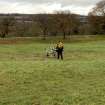
Resistivity (June 1989)
NS 818 794 In June 1989, a resistivity survey was conducted as part of an archaeological assessment in a field S of Seabegs Place, Bonnybridge in advance of house development.
Watching Brief (June 1989)
NS 8185 7950 The field to the S of Seabegs Place was trenched with the aid of a machine in advance of housing development. No features were located except at the N margin of the field. Here, hand dug trenches uncovered stone foundation material which may represent the S edge of the Military Way which would then have underlain the present track known as Seabegs Place. It is possible that the foundations related to the Medieval settlements here (Bailey 1989).

